National roads of Emerstari: Difference between revisions
No edit summary |
m (→National roads) |
||
| Line 52: | Line 52: | ||
|- | |- | ||
| 20 || [[Ålburg]] || [[Hjorring]] || {{convert|478|mi|km|disp=table}} | | 20 || [[Ålburg]] || [[Hjorring]] || {{convert|478|mi|km|disp=table}} | ||
|- | |||
| 21 || [[Eidfjord]] || [[Malmø]] || {{convert|310|mi|km|disp=table}} | |||
|- | |||
| 21 || [[Hjorring]] || [[Malmø]] || {{convert|185|mi|km|disp=table}} | |||
|- | |||
| 22 || [[Malmø]] || Coelanish border || {{convert|56|mi|km|disp=table}} | |||
|- | |||
| 24 || [[Malmø]] || [[Koppingburg]] || {{convert|103|mi|km|disp=table}} | |||
|- | |||
| 25 || [[Koppingburg]] || Coelanish border || {{convert|15|mi|km|disp=table}} | |||
|- | |- | ||
|} | |} | ||
Revision as of 23:40, 19 August 2019
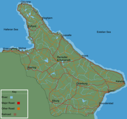
National roads (Emerstarian: riksvag; literally: country's road) in Emerstari have road numbers from 1 to 90, with 1 to 27 being Hogrutter (English: High routes). Generally, roads with lower numbers are in eastern Emerstari, and roads with higher numbers are in western Emerstari. There are numerous cases in this system where two or more routes share the same physical road for a considerable distance.
The national roads are public roads owned by the federal Government of Emerstari and administered by the Emerstarian Transportation Administration. They are known for generally having no mandated speed limit for most vehicle classes; limits are posted and enforced in urban, substandard, accident-prone, and construction areas. The Emerstarian Transportation Administration in 2014 reported that 78.7% of the national roads had only the advised speed limit of 136 km/h (85 mph), 7.5% had a temporary speed limit, and 13.8% had a permanent speed limit. They get a high priority for snow plowing during the winter.
The roads' number signs are rectangular with a blue background and white border. On it, is a white number.
National roads
| Number | Beginning point | Ending point | Length (mi) | Length (km) |
|---|---|---|---|---|
| 1 | Kalamer | Ljund | 117 | 188 |
| 2 | Kalamer | Yoerk | 376 | 605 |
| 3 | Yoerk | Uppsalle | 217 | 349 |
| 4 | Uppsalle | Stoghjem | 215 | 346 |
| 5 | Stoghjem | Olskrone | 216 | 348 |
| 6 | Ljund | Yoerk | 349 | 562 |
| 7 | Kalamer | Osterburg | 322 | 518 |
| 8 | Ljund | Osterburg | 216 | 348 |
| 9 | Yoerk | Rensulier | 175 | 282 |
| 10 | Uppsalle | Coronet | 218 | 351 |
| 11 | Stoghjem | Eidfjord | 191 | 307 |
| 12 | Olskrone | Eidfjord | 219 | 352 |
| 13 | Eidfjord | Coronet | 398 | 641 |
| 14 | Hoonderstad | Canarian border | 208 | 335 |
| 15 | Hoonderstad | Ålburg | 353 | 568 |
| 16 | Osterburg | Coelanish border | 308 | 496 |
| 17 | Osterburg | Ålburg | 266 | 428 |
| 18 | Rensulier | Ålburg | 429 | 690 |
| 19 | Coronet | Hjorring | 263 | 423 |
| 20 | Ålburg | Hjorring | 478 | 769 |
| 21 | Eidfjord | Malmø | 310 | 500 |
| 21 | Hjorring | Malmø | 185 | 298 |
| 22 | Malmø | Coelanish border | 56 | 90 |
| 24 | Malmø | Koppingburg | 103 | 166 |
| 25 | Koppingburg | Coelanish border | 15 | 24 |


