Talailau: Difference between revisions
No edit summary |
No edit summary |
||
| (3 intermediate revisions by the same user not shown) | |||
| Line 1: | Line 1: | ||
{{WIP}} | |||
{{Infobox country | {{Infobox country | ||
|conventional_long_name = Republic of Talailau | |conventional_long_name = Republic of Talailau | ||
| Line 11: | Line 12: | ||
|national_motto = Vakacegu kei na Sautu | |national_motto = Vakacegu kei na Sautu | ||
|englishmotto = <small>"Peace and Prosperity"</small> | |englishmotto = <small>"Peace and Prosperity"</small> | ||
|national_anthem = | |national_anthem = Dusimaki Mai Lomalagi <br> [[File:MediaPlayer.png|link=https://www.youtube.com/watch?v=4ebQq0yZP7E|200px]] | ||
|royal_anthem = | |royal_anthem = | ||
|other_symbol_type = <!--Use if a further symbol exists, e.g. hymn--> | |other_symbol_type = <!--Use if a further symbol exists, e.g. hymn--> | ||
|other_symbol = | |other_symbol = | ||
|image_map = [[File: | |image_map = [[File:Tailalauoe.png|230px]] | ||
|alt_map = <!--alt text for map--> | |alt_map = <!--alt text for map--> | ||
|map_caption = Location of Talailau (in green) in X (grey). | |map_caption = Location of Talailau (in green) in X (grey). | ||
| Line 121: | Line 122: | ||
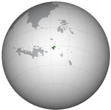
'''Talailau''' ({{wp|Help:IPA/Fijian|/talɛilɔu/}}; {{wp|Fijian language|Talailauan}}: ''Talailau'') known officially as the '''Republic of Talailau''' ({{wp|Fijian language|Talailauan}}: ''Matanitu Tugalala o Talailau''), is {{wp|sovreign state}} in X. It is bounded by the X sea on all sides, sharing maritime borders with X to the west, and X to the north and east. Comprising of the island of X and its offshore islands in the X Sea, Talailau spans an area of X sq. km (X sq. mi) and has a population of around 4 million. | '''Talailau''' ({{wp|Help:IPA/Fijian|/talɛilɔu/}}; {{wp|Fijian language|Talailauan}}: ''Talailau'') known officially as the '''Republic of Talailau''' ({{wp|Fijian language|Talailauan}}: ''Matanitu Tugalala o Talailau''), is {{wp|sovreign state}} in X. It is bounded by the X sea on all sides, sharing maritime borders with X to the west, and X to the north and east. Comprising of the island of X and its offshore islands in the X Sea, Talailau spans an area of X sq. km (X sq. mi) and has a population of around 4 million. | ||
The first inhabitants of the islands were the native {{wp|Fijian people|Tailailauans}} who arrived from western {{wp|Melanesia}} around 3,500 years ago. These early settlers mixed with later arrivals of {{wp|Polynesians}} to develop the modern Talailauan culture. Talailau was first discovered by X in XXXX, beginning a period of contact and visits from Xeans. The island was united under a single kingdom in XXXX for a brief period, before the X Empire established a protectorate over the islands in XXXX. | |||
Talailau changed hands multiple times during its colonial period, with X colonizers taking over the colony in XXXX before returning back to X, and finally becoming a colony of X in XXXX. After a prolonged period of X rule, Talailau was awarded self-government in 19XX, gaining full independence later that same year. | Talailau changed hands multiple times during its colonial period, with X colonizers taking over the colony in XXXX before returning back to X, and finally becoming a colony of X in XXXX. After a prolonged period of X rule, Talailau was awarded self-government in 19XX, gaining full independence later that same year. | ||
The island of [[Matema]] was administered as part of the colony and was thus part of the newly independent Republic of Talailau, much to the resentment of the local {{wp|Samoan|Matemans}}, a {{wp|Polynesian}} ethnic group culturally and lingustically different from the rest of the country. | |||
Today, | Post-independence, a {{wp|massacre}} of ethnically Mateman demonstrators on the island of Matema at the hands of the Talailauan military in 19XX culminated in the beginning of the Coconut War with seperatists of the Mateman People's Liberation Army. Peace was achieved under the government of President Waisale Naivalu in 1999, however his killing and subsequent military takeover in 2006 has led to the flaring up of tensions on the island. | ||
Today, the country remains under a {{wp|military junta}} and is facing a low-level {{wp|insurgency}} on Matema which has led to the deaths of many civillians and members of the security forces. Talailau's capital is the port town of Nunuvaka, the largest city which also functions as the main center of business of the islands. | |||
Talailau's economy is primarily based on the {{wp|service sector}}, which acounts for over 70% of the nation's {{wp|gross domestic product}}. {{wp|Agriculture}} also plays a significant role, along with {{wp|remittance}} from overseas Talailauans. | Talailau's economy is primarily based on the {{wp|service sector}}, which acounts for over 70% of the nation's {{wp|gross domestic product}}. {{wp|Agriculture}} also plays a significant role, along with {{wp|remittance}} from overseas Talailauans. | ||
| Line 133: | Line 136: | ||
Talailau is a full member of X, and is an observer in the X and X. | Talailau is a full member of X, and is an observer in the X and X. | ||
==History== | ==History== | ||
===Early history=== | [[File:BurialMoundTalailau.png|thumb|225px|left|Depiction of the "skull shrine" in [[Balavu]].]] | ||
===Early settlement=== | |||
The early history of Talailau is obscure, with the most common theory being that the islands were first settled by {{wp|Melanesian}} settlers around 3,500 years ago. Archeological evidence has led to the discovery of {{wp|pottery}} fragments dating back to 1300 BC. Several structures preceeding X contact still remain on the islands, including the 'skull-shrines' found in the regions of Balavu and Dra. According to {{wp|oral tradition}}, the island was under the control of the Chief of Dra, with the Dra Chiefdom having been a regional power from the 16th to 18th centuries. | |||
Fragments of pottery and remains of shrines and other structures in the area points to the chiefdom being the centre of regional trade. The skull-shrines of Balavu are evidence of the chiefdom's power – the skulls of the skull-shrines are in fact the skulls of enemy warriors killed during various {{wp|head-hunting}} expeditions throughout the height of the chiefdom's power. | |||
Later, the arrival of {{wp|Polynesian}} settlers and subsequent intermixture of the two groups led to the adoption of many Polynesian customs and influences on the local culture and the language of Talailau. | |||
[[File:TalailauDrua.jpg|thumb|250px|right|{{wp|Ndrua}} trading vessels dominated regional trade routes]] | |||
Large, elegant watercraft called {{wp|ndrua}} were constructed in Talailau, used by the local chiefdoms for trade and warring. The vessels were some of the largest constructed prior to X contact, carrying hundreds of people and up to 30m long. Local chiefs led fleets of ndrua to other islands and dominated the oceanic trade. Ndrua were even exported to Matema, whose chiefs purchased or brought back as {{wp|prize ship|prizes}} of war and replaced local outrigger canoe designs. | |||
===!European contact=== | |||
[[File:John Cleveley the Younger, HMS Resolution and Discovery in Tahiti.jpg|thumb|left|240px|The arrival of Captain X and his fleet in Balavu, 17XX.]] | |||
The first contact with !Europeans occured in 16XX, when X sailor, Captain X, arrived on the island of Raraba. The X established a short lived settlement at Tanatoba Bay before being driven off by native tribes after which the colony was abandoned. | |||
!Europeans did not arrive until X navigator, X, visited the islands in 17XX. As part of the expedition, the islands were charted and plotted for the first time. Despite this, however, no permanent attempts were made to settle the islands. | |||
The islands and its people were frequently visited by {{Wp|whaling|whalers}}, using the islands as shelter and coming on shore for food and drinking water in the late 18th century. Later, native crewmen were recruited to serve onboard vessels and the natives provided an easy source of manpower. Later, both the X and X empires attempted to establish colonies on the islands which largely resulted in failure. | |||
* arrival of missionaries, conversion of the population | |||
* {{wp|blackbirding}} is a problem | |||
* X empire declares protectorate over islands | |||
The protectorate was later expanded to include the island of [[Matema]] and several other outlying islands. | |||
===Independence=== | |||
[[File:Independence_ceremonytail.png|left|thumb|225px|Independence ceremony, 19XX]] | |||
The islands gained independence in 19XX. | |||
==Geography and climate== | ==Geography and climate== | ||
===Climate=== | ===Climate=== | ||
{{Weather box | |||
|location = Nunuvaka | |||
|width = 80% | |||
|metric first = yes | |||
|single line = yes | |||
|Jan record high C = 32 | |||
|Feb record high C = 32 | |||
|Mar record high C = 31 | |||
|Apr record high C = 30 | |||
|May record high C = 30 | |||
|Jun record high C = 28 | |||
|Jul record high C = 28 | |||
|Aug record high C = 28 | |||
|Sep record high C = 28 | |||
|Oct record high C = 29 | |||
|Nov record high C = 30 | |||
|Dec record high C = 31 | |||
|year record high C = 32 | |||
|Jan high C = 28 | |||
|Feb high C = 29 | |||
|Mar high C = 28 | |||
|Apr high C = 27 | |||
|May high C = 26 | |||
|Jun high C = 25 | |||
|Jul high C = 25 | |||
|Aug high C = 24 | |||
|Sep high C = 25 | |||
|Oct high C = 25 | |||
|Nov high C = 27 | |||
|Dec high C = 27 | |||
|year high C = 26 | |||
|Jan mean C = 25 | |||
|Feb mean C = 25 | |||
|Mar mean C = 25 | |||
|Apr mean C = 24 | |||
|May mean C = 23 | |||
|Jun mean C = 21 | |||
|Jul mean C = 21 | |||
|Aug mean C = 21 | |||
|Sep mean C = 21 | |||
|Oct mean C = 22 | |||
|Nov mean C = 23 | |||
|Dec mean C = 23 | |||
|year mean C = 23 | |||
|Jan low C = 22 | |||
|Feb low C = 22 | |||
|Mar low C = 22 | |||
|Apr low C = 21 | |||
|May low C = 20 | |||
|Jun low C = 18 | |||
|Jul low C = 17 | |||
|Aug low C = 18 | |||
|Sep low C = 17 | |||
|Oct low C = 19 | |||
|Nov low C = 20 | |||
|Dec low C = 20 | |||
|year low C = 20 | |||
|Jan record low C = 16 | |||
|Feb record low C = 17 | |||
|Mar record low C = 15 | |||
|Apr record low C = 15 | |||
|May record low C = 13 | |||
|Jun record low C = 11 | |||
|Jul record low C = 10 | |||
|Aug record low C = 11 | |||
|Sep record low C = 11 | |||
|Oct record low C = 12 | |||
|Nov record low C = 13 | |||
|Dec record low C = 16 | |||
|year record low C = 10 | |||
|rain colour=green | |||
|Jan rain mm = 130 | |||
|Feb rain mm = 190 | |||
|Mar rain mm = 210 | |||
|Apr rain mm = 120 | |||
|May rain mm = 130 | |||
|Jun rain mm = 100 | |||
|Jul rain mm = 100 | |||
|Aug rain mm = 130 | |||
|Sep rain mm = 110 | |||
|Oct rain mm = 90 | |||
|Nov rain mm = 100 | |||
|Dec rain mm = 120 | |||
|Jan rain days = 11 | |||
|Feb rain days = 13 | |||
|Mar rain days =14 | |||
|Apr rain days = 12 | |||
|May rain days = 12 | |||
|Jun rain days = 10 | |||
|Jul rain days = 10 | |||
|Aug rain days = 12 | |||
|Sep rain days = 10 | |||
|Oct rain days = 10 | |||
|Nov rain days = 10 | |||
|Dec rain days = 10 | |||
|Jan humidity = 77 | |||
|Feb humidity = 78 | |||
|Mar humidity = 79 | |||
|Apr humidity = 76 | |||
|May humidity = 78 | |||
|Jun humidity = 77 | |||
|Jul humidity = 75 | |||
|Aug humidity = 75 | |||
|Sep humidity = 74 | |||
|Oct humidity = 74 | |||
|Nov humidity = 73 | |||
|Dec humidity = 75 | |||
|source 1 = Solomone Manueli University, Nunuvaka | |||
|date=February 2005 | |||
}} | |||
==Government== | ==Government== | ||
==Demographics== | ==Demographics== | ||
| Line 143: | Line 286: | ||
==Infrastructure== | ==Infrastructure== | ||
===Transport=== | ===Transport=== | ||
[[File:Its_a_bustalailau.png|left|250px|thumb|A trans-island bus in [[Bua]]]] | |||
Talailau's road system remains extremely undeveloped, with fewer than 200 kilometers of paved roads. The roadways on the island consist mostly of dirt tracks suitable only for four-wheel-drive vehicles. Busses are the main mode of transport in Talailau, connecting small inland villages with the rest of the country. There are no railways on Talailau, and the country only has two operational airports. | |||
===Healthcare=== | ===Healthcare=== | ||
==Culture== | ==Culture== | ||
[[File:tllTrad_women.png|right|225px|thumb|Talailauan women in traditonal garments.]] | |||
==See also== | ==See also== | ||
Latest revision as of 04:30, 1 April 2020
This article is incomplete because it is pending further input from participants, or it is a work-in-progress by one author. Please comment on this article's talk page to share your input, comments and questions. Note: To contribute to this article, you may need to seek help from the author(s) of this page. |
Republic of Talailau Matanitu Tugalala o Talailau (Talailauan) | |
|---|---|
| Motto: Vakacegu kei na Sautu "Peace and Prosperity" | |
| Anthem: Dusimaki Mai Lomalagi | |
 Location of Talailau (in green) in X (grey). | |
| Capital and | Nunuvaka |
| Official languages | Talailauan |
| Active Military | 2,572 (2015) |
| Ethnic groups | 72.6% Talailauan 18.3% Mateman 10.1% Others |
| Demonym(s) | Tailailauan |
| Government | Unitary parliamentary republic |
| Ma'afu Vakaloloma | |
| Lau Takiveikata | |
| Legislature | Parliament |
| Independence | |
• X | X |
• X | X |
| Area | |
• | 00,000 km2 (0 sq mi) |
| Population | |
• 2014 census | 4,347,239 |
• Density | 000/km2 (0.0/sq mi) |
| GDP (nominal) | 2017 estimate |
• Total | $16.122 billion |
• Per capita | $3,709.84 |
| Gini (2014) | 45.9 medium |
| HDI (2017) | 0.707 high |
| Currency | tabua (TLT) |
| Date format | dd.mm.yyyy |
| Driving side | right |
| Calling code | +420 |
| ISO 3166 code | TLL |
| Internet TLD | .tl |
Talailau (/talɛilɔu/; Talailauan: Talailau) known officially as the Republic of Talailau (Talailauan: Matanitu Tugalala o Talailau), is sovreign state in X. It is bounded by the X sea on all sides, sharing maritime borders with X to the west, and X to the north and east. Comprising of the island of X and its offshore islands in the X Sea, Talailau spans an area of X sq. km (X sq. mi) and has a population of around 4 million.
The first inhabitants of the islands were the native Tailailauans who arrived from western Melanesia around 3,500 years ago. These early settlers mixed with later arrivals of Polynesians to develop the modern Talailauan culture. Talailau was first discovered by X in XXXX, beginning a period of contact and visits from Xeans. The island was united under a single kingdom in XXXX for a brief period, before the X Empire established a protectorate over the islands in XXXX.
Talailau changed hands multiple times during its colonial period, with X colonizers taking over the colony in XXXX before returning back to X, and finally becoming a colony of X in XXXX. After a prolonged period of X rule, Talailau was awarded self-government in 19XX, gaining full independence later that same year.
The island of Matema was administered as part of the colony and was thus part of the newly independent Republic of Talailau, much to the resentment of the local Matemans, a Polynesian ethnic group culturally and lingustically different from the rest of the country.
Post-independence, a massacre of ethnically Mateman demonstrators on the island of Matema at the hands of the Talailauan military in 19XX culminated in the beginning of the Coconut War with seperatists of the Mateman People's Liberation Army. Peace was achieved under the government of President Waisale Naivalu in 1999, however his killing and subsequent military takeover in 2006 has led to the flaring up of tensions on the island.
Today, the country remains under a military junta and is facing a low-level insurgency on Matema which has led to the deaths of many civillians and members of the security forces. Talailau's capital is the port town of Nunuvaka, the largest city which also functions as the main center of business of the islands.
Talailau's economy is primarily based on the service sector, which acounts for over 70% of the nation's gross domestic product. Agriculture also plays a significant role, along with remittance from overseas Talailauans.
Talailau is a full member of X, and is an observer in the X and X.
History

Early settlement
The early history of Talailau is obscure, with the most common theory being that the islands were first settled by Melanesian settlers around 3,500 years ago. Archeological evidence has led to the discovery of pottery fragments dating back to 1300 BC. Several structures preceeding X contact still remain on the islands, including the 'skull-shrines' found in the regions of Balavu and Dra. According to oral tradition, the island was under the control of the Chief of Dra, with the Dra Chiefdom having been a regional power from the 16th to 18th centuries.
Fragments of pottery and remains of shrines and other structures in the area points to the chiefdom being the centre of regional trade. The skull-shrines of Balavu are evidence of the chiefdom's power – the skulls of the skull-shrines are in fact the skulls of enemy warriors killed during various head-hunting expeditions throughout the height of the chiefdom's power.
Later, the arrival of Polynesian settlers and subsequent intermixture of the two groups led to the adoption of many Polynesian customs and influences on the local culture and the language of Talailau.

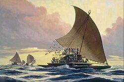
Large, elegant watercraft called ndrua were constructed in Talailau, used by the local chiefdoms for trade and warring. The vessels were some of the largest constructed prior to X contact, carrying hundreds of people and up to 30m long. Local chiefs led fleets of ndrua to other islands and dominated the oceanic trade. Ndrua were even exported to Matema, whose chiefs purchased or brought back as prizes of war and replaced local outrigger canoe designs.
!European contact
The first contact with !Europeans occured in 16XX, when X sailor, Captain X, arrived on the island of Raraba. The X established a short lived settlement at Tanatoba Bay before being driven off by native tribes after which the colony was abandoned.
!Europeans did not arrive until X navigator, X, visited the islands in 17XX. As part of the expedition, the islands were charted and plotted for the first time. Despite this, however, no permanent attempts were made to settle the islands.
The islands and its people were frequently visited by whalers, using the islands as shelter and coming on shore for food and drinking water in the late 18th century. Later, native crewmen were recruited to serve onboard vessels and the natives provided an easy source of manpower. Later, both the X and X empires attempted to establish colonies on the islands which largely resulted in failure.
- arrival of missionaries, conversion of the population
- blackbirding is a problem
- X empire declares protectorate over islands
The protectorate was later expanded to include the island of Matema and several other outlying islands.
Independence
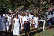
The islands gained independence in 19XX.
Geography and climate
Climate
| Climate data for Nunuvaka | |||||||||||||
|---|---|---|---|---|---|---|---|---|---|---|---|---|---|
| Month | Jan | Feb | Mar | Apr | May | Jun | Jul | Aug | Sep | Oct | Nov | Dec | Year |
| Record high °C (°F) | 32 (90) |
32 (90) |
31 (88) |
30 (86) |
30 (86) |
28 (82) |
28 (82) |
28 (82) |
28 (82) |
29 (84) |
30 (86) |
31 (88) |
32 (90) |
| Average high °C (°F) | 28 (82) |
29 (84) |
28 (82) |
27 (81) |
26 (79) |
25 (77) |
25 (77) |
24 (75) |
25 (77) |
25 (77) |
27 (81) |
27 (81) |
26 (79) |
| Daily mean °C (°F) | 25 (77) |
25 (77) |
25 (77) |
24 (75) |
23 (73) |
21 (70) |
21 (70) |
21 (70) |
21 (70) |
22 (72) |
23 (73) |
23 (73) |
23 (73) |
| Average low °C (°F) | 22 (72) |
22 (72) |
22 (72) |
21 (70) |
20 (68) |
18 (64) |
17 (63) |
18 (64) |
17 (63) |
19 (66) |
20 (68) |
20 (68) |
20 (68) |
| Record low °C (°F) | 16 (61) |
17 (63) |
15 (59) |
15 (59) |
13 (55) |
11 (52) |
10 (50) |
11 (52) |
11 (52) |
12 (54) |
13 (55) |
16 (61) |
10 (50) |
| Average rainfall mm (inches) | 130 (5.1) |
190 (7.5) |
210 (8.3) |
120 (4.7) |
130 (5.1) |
100 (3.9) |
100 (3.9) |
130 (5.1) |
110 (4.3) |
90 (3.5) |
100 (3.9) |
120 (4.7) |
1,530 (60) |
| Average rainy days | 11 | 13 | 14 | 12 | 12 | 10 | 10 | 12 | 10 | 10 | 10 | 10 | 134 |
| Average relative humidity (%) | 77 | 78 | 79 | 76 | 78 | 77 | 75 | 75 | 74 | 74 | 73 | 75 | 76 |
| Source: Solomone Manueli University, Nunuvaka | |||||||||||||
Government
Demographics
Economy
Infrastructure
Transport

Talailau's road system remains extremely undeveloped, with fewer than 200 kilometers of paved roads. The roadways on the island consist mostly of dirt tracks suitable only for four-wheel-drive vehicles. Busses are the main mode of transport in Talailau, connecting small inland villages with the rest of the country. There are no railways on Talailau, and the country only has two operational airports.


