Umetuč: Difference between revisions
No edit summary |
|||
| (69 intermediate revisions by the same user not shown) | |||
| Line 1: | Line 1: | ||
The | The Unitary Republic of North Umetuč ([[Tokagebač]]: ''Ւմետւճ'' [[Tokagebac|[u.ˈmɛ.tʼut͡ʃ]]]) is a unitary autoritarian parliamentary republic on the northern edges of the continent of [[Kitkras]] in [[Sonhel]]. It takes its name from the island of Umetuč, of which it occupies the northern part. The current territories occupied by the Republic of North Umetuč were firstly settled in the 10th century by the nomadic tribes who will later adopt the names of ''[[Tokagebač]]'', ''[[Cruiniiral]]'' and ''[[Valtarans]]''. Umetuč shares the island with the [[Nova Albion|Kingdom of Nova Albion]] to the south, which controls the central part of the island. | ||
{{Infobox country | {{Infobox country | ||
|conventional_long_name = The | |conventional_long_name = The Unitary Republic of North Umetuč | ||
|native_name = '''''Mesa Umetučobe Nekjagoxo | |native_name = '''''Mesa Umetučobe Nekjagoxo Nekekra''''' | ||
|common_name = Umetuč | |common_name = Umetuč | ||
|image_flag = [[File:UmetučFlag.png|300px]] | |image_flag = [[File:UmetučFlag.png|300px]] | ||
|image_coat = [[File:Immagine 2023-05-10 201607070.png|200px]] | |image_coat = [[File:Immagine 2023-05-10 201607070.png|200px]] | ||
|national_motto = '' '' | |national_motto = '' '' | ||
|national_anthem = '' '' | |national_anthem = ''Ube D̨ugoxočeb'' (The Red House) | ||
|image_map = | |image_map = [[File:Immagine 2023-06-11 175808261.png|400px]] [[File:Immagine 2023-06-11 175954048.png|400px]] | ||
|map_caption = ''Map of North Umetuč in | |map_caption = ''Map of North Umetuč in 2416'' | ||
|capital = Tålakjemeqa | |capital = Tålakjemeqa (''Տօլակյեմեհա'') | ||
|largest_city = Tålakjemeqa | |largest_city = Tålakjemeqa | ||
|official_languages = [[Tokagebac]] | |official_languages = [[Tokagebac]] | ||
|national_languages = | |national_languages = Tokagebač, [[Xopukuli]], [[Mtàd Tokagebač]] | ||
|regional_languages = | |regional_languages = Tokagebač, [[Cruiniiral]], [[Ax tot Yonn]], [[Dj̆ty]], Xopukuli, [[Muippelore]], Mtàd Tokagebač, [[Dïkïnns]] | ||
|ethnic_groups = [[Tokagebac]], [[Xopukuli]], [[Mtàd Tokagebac]], [[Cruiniiral]], [[Ax tot Yonn]], [[Dj̆ty]], [[Muippelore]] | |ethnic_groups = [[Tokagebac]], [[Xopukuli]], [[Mtàd Tokagebac]], [[Cruiniiral]], [[Ax tot Yonn]], [[Dj̆ty]], [[Muippelore]], [[Valtarans]], Dïkïnns | ||
|demonym = Umetučite, | |demonym = Umetučite, Tokagebač | ||
|government_type = Autoritarian parlamentary federal republic | |government_type = Autoritarian parlamentary federal republic | ||
|leader_title1 = President | |leader_title1 = President | ||
| Line 27: | Line 27: | ||
|established_event3 = Intervention in the [[Valtaran Civil War]] and establishment of the United Republics of North Umetuč | |established_event3 = Intervention in the [[Valtaran Civil War]] and establishment of the United Republics of North Umetuč | ||
|established_date3 = 2403 | |established_date3 = 2403 | ||
|area = | |established_event4 = Establishment of the Unitary Republic of North Umetuč | ||
|population_estimate = | |established_date4 = 2410 | ||
|population_density_km2 = | |area = 1.3 million km^2 | ||
|GDP_nominal = | |population_estimate = 32 million | ||
|HDI = | |population_density_km2 = 24 | ||
|currency = Nekjagod (₦) | |GDP_nominal = 118.6 billion ₦ (6 billion US$) | ||
|HDI = 0.5 | |||
|currency = Nekjagod (₦) (1US$ = 1788₦) | |||
|date_format = DD/MM/YYYY | |date_format = DD/MM/YYYY | ||
|drives_on = Right | |drives_on = Right | ||
| Line 38: | Line 40: | ||
==History== | ==History== | ||
===Prehistory=== | |||
The first signs of civilization in North Umetuč date back to the late 10th century. Around this time are said to belong the first settlements and metal tools found in the regions around the B̨obočim river. These findings are thought to belong to the first Tokagebac inhabitants of the island and that are thought to have originated in the valley around the Gnawing Gulf. Not much more informations are available regarding this era of Umetuč's history, apart form the fact that, according to analyzes conducted by the [[Tålakjemeqa Archeology Department]], the communities inhabiting these dwellings used to construct them out of loose rocks and wes common practice use them during the cold months just to return to a seminomadic lifestyle once summer arrived. These tiny stone huts are still present on the territory and are called by the local Tokagebč population Pagjabra ([[Tokagebač]]: ''Պագյաբռա'' [p'ä.kjä.prä]). | |||
The first written accounts recovered on the west side of the mountains are dated to the late 12th century and are written in an unknown language, possibly an old extinct [[Brogåd]] language related to modern [[Tokagebač]]. The most relevant of these finds is a clay tablet dug up in the sorroundings of the modern city of [[Dičod̨o]] along the ruins of a large pagjabra village. | |||
The first evidence of organized communities in this regions came from the early 13th century with the finding of an old document inscripted on a paper-like material in a large ruined building on the side of the mountain range. This document is thought to be some kind of religious document due to its peculiar location. In this period is also thought to begin the expansion of the Tokagebač southwards. | |||
In 2378 were recovered, in a field west of [[Totoglat]], several bronze weapons and armor pieces along as several isolated pagjabras encircling this supposed 2,5 km² battle ground. The equipment found in this region was classified in two distinct groups based on material and design: Tokagebač and Cruiniiral. This is the first piece of evidence backing the theory of the Cruiniiral's nativity to the Umetuč island. | |||
===Early Kingdoms and migrations=== | |||
According to the [[Tålakjemeqa Archeology Department|TAD]], the first Tokagebač and Cruiniiral kingdoms were established in the middle of the 16th century along the northern coasts of the island as well as remote regions across the mountains. These kingdoms were in constant war and competed with each other for resources and hegemony over the sorrounding tribes. This situation was escalated by a massive migration of [[Alftheimn]] sailors that came from the south-east and decided to settle on the eastern coast of the island. These groups of firstly settled in uninhabitaed valleys north of the mountains but later decided to expand to the south, engaging smaller and weaker Tokagebač villages and kingdoms in battle and raiding stronger settlements and communities. | |||
Another important migration came from the [[Syrovoho|Syrovohan islands]] in the south. These immigrants spoke a language belonging to the [[Autrosyrovohic]] family and its only descendent, [[Dƿty]], is related to the [[Lichrenean languages]]. Like their northen counterparts, the Syrovohan settelers began to raid and pillage the Tokagebač natives and expanded around the [[Belly Gulf]] coast. | |||
===Tokagebač Hegemony=== | |||
From written accounts and archeological findings, we can confidently say that, since the second half of the 19th century, the [[Kingdom of G̨enečeban]], which was a form of proto-federal entity where a single monarch (Tokagebač: Եպտամատե /ɛp't'ämät'/) ruled over many vassal and tributary states, had imposed itself as the leading military power in the area of the Gnawing Gulf. G̨enečeban had vassalized several small kingdoms and had defeated in war the Cruiniirals several times in the previous decades. At the same time, G̨enečeban had also established economic relations with the Xopukuli kingdoms in the east and began to gradually aquire more influence and respect among their ruling class. The most relevant market they shared was the Xopukuli weapons market, which funded the G̨enečeban war effort against their Cruiniiral rivals who, since the first contact with the Tokagebač, have always fought for land, resources and hegemony in the western areas of the island. This relationships between the Tokagebač and the Xopukuli solidified over the decades and mutated into a kind of simbiotic relationship where, while the Tokagebač continued their expansion in the south and conflicts in the west, the Xopukuli managed to export their culture and traditions to the point where G̨enečeban embraced [[Cult of the Insane One|Delusional Amarianism]] and popularized among the Tokagebač elite and spreading it to the civilian population and in the growing [[Mtàd Toakgebač|Mtàd]] population. | |||
==Geography== | ==Geography== | ||
Umetuč is located on the northern half of the main island of the Tumetuč Archipelago, called Umetuč. The country is split in two sides by the ''Čytmekjem'' mountan range | Umetuč is located on the northern half of the main island of the Tumetuč Archipelago, called Umetuč. The country is split in two sides by the ''Čytmekjem'' mountan range. | ||
The highest peak inside Umetučite border is the ''Ubebro'' mountain which stands at around | The highest peak inside Umetučite border is the ''Ubebro'' mountain which stands at around 5100 meters in the northern regions of the country. The ''Ubebro'' is also the source of the only river in the Umetuč island: the ''B̨obočim'', which untimately flows in the ''Gnawing Sea'' (the area of the ocean between the minor ''Axtyonn Umetuč Islands'' and the ''Gnawing Gulf'') splitting the capital [[Tålakjemeqa]] in half. | ||
North Umetuč is located | North Umetuč is located north of the equatorial belt and is therefore mostly covered in thick rainforests and savannas from the Gnawing Guld to the southern tip of the island. It also includes, in its western regions, a small chunk of sandy desert and dry regions that covers the western coasts of the island. Normally North Umetuč experiences a wet and hot season, which lasts between three and four months, along a colder season, in which precipitaion are slightly less abundant and average temperatures decrease by a few degrees. | ||
==Politics and government== | ==Politics and government== | ||
North Umetuč was a federal parlamentary republic founded in 2402 after the collapse of the [[Valtara|Valtaran States]] in the [[Valtaran Civil War]]. It includes the [[Greater G̨enseba|Region of Greater G̨enseba]], the [[Xirakekunnae|Region of Xirakekunnae]], the [[C'aarllaac|Region of C'aarllaac]] and the [[Miše|Region of New Miše]]. In 2410 North Umetucà became a centralized republic with a unitary government, transforming the previous member republics in autonomous regions. Each of the regions have their own local bicameral parliament which has to enforce federally appproved laws and directives or has the possibility to contest them and have them adapted to their territory. The republics can also enforce exclusive laws that do not conflict with already approved federal laws and that do not regard economic policies, law and order, foreign politics, production and industrial projects and national defense. The federal government, composed of the president (which since 2405 also holds executive power) and of the bicameral parliament formed by elected representatives from the republics, is a supernational entity and has the power to impose laws and rules on the republics. The parliament is elected every four years with a proportional popular vote. The president is later elected by the two chambers of parliament every five years. The parliament can depose the current president and replace them thanks to a vote of no confidence that requires two thirds of both chambsers to pass. The president can disbandle one of the two chambers of parliament with a vote that needs 80% of the votes from the other parliament chamber. | |||
North Umetuč | |||
===Military=== | ===Military=== | ||
The Umetuč Armed Forces are split between Field Army and Navy. Both these entities are controlled by the | The Umetuč Armed Forces are split between Field Army and Navy. Both these entities are controlled by the national government but are internally administrated by generals and admirals elected by parliament every six years. | ||
===Foreign relations=== | ===Foreign relations=== | ||
North Umetuč is a founding member of the [[The Amarian Combine|Amarian Combine]] and is currently its leader. It also is a founding member of the [[Transnational Assembly]], association from which Umetuč has been pregressively less prominent and enthusiastically participant in. North Umetuč is a member of the [[ | North Umetuč is a founding member of the [[The Amarian Combine|Amarian Combine]] and is currently its leader. It also is a founding member of the [[Transnational Assembly]], association from which Umetuč has been pregressively less prominent and enthusiastically participant in. North Umetuč is a member of the [[Northern Economic Zone]] since 2407 and has created tight economic, political and cultural relations with its members. | ||
[[File:Immagine 2023-05-30 185732876.png|thumb|Region and province map of North Umetuč in 2412]] | |||
==Economy== | ==Economy== | ||
Umetuč is an industrialized nation with a triving mining industry and weapon production sector. As of | Umetuč is an industrialized nation with a triving mining industry and weapon production sector. As of 2411, Umetuč has an employement rate of around 80% thanks to its [https://en.wikipedia.org/wiki/Economic_interventionism interventionist] policies and its ban on private enterprises, generating a GDP of about 6000 billion ₦. The government has virtually full control over the primary and secondary secotrs of th ecountry and has liberalized mostly the retail, communication and turism sectors. Freelance work is also accepted in Umetuč as long as its declared to and approved by the government, which makes sure it is taxed appropriately. | ||
===Energy=== | ===Energy=== | ||
Most of the Energy production in Umetuč comes from its rich coal mines scattered all over the country. Each | Most of the Energy production in Umetuč comes from its rich coal mines and fossil fuel deposits scattered all over the country. Each region has access to several mines and refinery stations capable of producing several thousands tons of coal yearly, which are than shipped to the rest of the country to power most of its industrial apparatus. Some of the largest cities are almost entirely powered by coal implants that produce a moderate amount of electricity. | ||
===Industry=== | ===Industry=== | ||
North Umetuč is a fairly industrialized nation. It's most developed sectors are: common metals extraction and refinery, artillery and weapon production, asphalt and concrete production, chemical manufacturing, glass manufacturing. These sectors are more developed than others thanks to the specific resources and minerals available inside Nort Umetuč's borders. Along these industries, North Umetuč has a fairly developed timber and fishing industry. Due to the dense raiforests and | North Umetuč is a fairly industrialized nation. It's most developed sectors are: common and rare metals extraction and refinery, artillery and weapon production, asphalt and concrete production, chemical manufacturing, glass manufacturing. These sectors are more developed than others thanks to the specific resources and minerals available inside Nort Umetuč's borders. Along these industries, North Umetuč has a fairly developed timber and fishing industry. Due to the dense raiforests and overall inhospitable terrain and poor soil, intensive agriculture is not a very remunerating area. | ||
[[File:Immagine 2023-05-30 185916447.png|thumb|Industrialization level in North Umetuč provnces in 2412]] | |||
==Demographics== | ==Demographics== | ||
North Umetuč is home to several ethnic groups and communities. The most prominent and numerous of these are the Tokagebač and the Mtàd Tokagebač, native to the northern areas of the island. The two Tokagebač groups have always been collaborating since the recent (late 23th century) split from which the Mtàd split from their western cousins. Some scholars argue that the linguistic differences between these communities are irrelevant and that the Tokagebač and the Mtàd are actually still part of the same ethnic cathegory. Another Indigenous group is the Cruiniiral, native to the western coast of the country. Unlike the Tokagebač, the Cruiniiral diverged into two separate groups back in the early 20th century, event from which the Ax Tot Yonn, who inhabited the | North Umetuč is home to several ethnic groups and communities. The most prominent and numerous of these are the Tokagebač and the Mtàd Tokagebač, native to the northern areas of the island. The two Tokagebač groups have always been collaborating since the recent (late 23th century) split from which the Mtàd split from their north-western cousins. Some scholars argue that the linguistic differences between these communities are irrelevant and that the Tokagebač and the Mtàd are actually still part of the same ethnic cathegory. Another Indigenous group is the Cruiniiral, native to the north-western coast of the country. Unlike the Tokagebač, the Cruiniiral diverged into two separate groups back in the early 20th century, event from which the Ax Tot Yonn, who inhabited the Axtyonn Islands, were born. These two groups have always been in conflict with the Tokagebač nations since the early days of their existance but were ultimately defeated and assimilated into Tokagebač society after the [[Second Cruiniiral War]] (2361-2366). Another native minority in the west of the country is the [[Valtarans]], a previously prosperous and numerous community that, after the fall of the Valtaran States after the [[Valtaran Civil War]] of 2403, is now reduced to a small community mostly inhabiting the city of [[Lambracaia]] ([[Tokagebac]]: ''Լամեբռագյա'' [lä.mɛ.ˈprä.kjä]; [[Valtaran]]: ''Lambracaia'' [lam.bɾa.ˈka.ja]) and the sorrounding areas. | ||
===Education=== | ===Education=== | ||
National standardized mandatory education | National standardized mandatory (from 6 to 16 years of age) education has been introduced by the Mepodo administration in 2404. Until then, children recieved a local education from their parents or some kind of municipal or provincial education program which was also completely optional. Not many were able to read or write and this negatively effected the economy of the country. The new school system of North Umetuč teaches children the national language, the history of their country and has the goal of creating an Umetučite national identity. | ||
===Religion=== | ===Religion=== | ||
The most widespread religious belief in North Umetuč is the [[Cult of the Insane One]] (or [[Cult of the Insane One|Akixokukfyr Cult]] or [[Cult of the Insane One|Delusional Amarianism]]). [[Cult of the Insane One|The Cult of the Insane One]] is an unorthodox sect related to the [[Tarahanic religions]] that was imported in the Tumetuč archipelago by [[Alftheimn|Alftheimnish]] sailors. Other minor religions and cults are the traditionalist [[Cruiniiral Vail]], animist religions that worship natural forces related to the sea, teh jungle and the desert. | |||
[[File:Immagine 2023-05-30 190017067.png|thumb|Ethno-linguistic map of North Umetuč in 2412]] | |||
==Culture== | ==Culture== | ||
Umetučite culture is a melting pot of the various customs and ideas brought by the several cultures that live within its borders and its, for this reason, extremely diverse from region to region and even from city to city. Most of the values of strength of mind, courage and perceverence that the Umetučite population values and respects were brought by the Tokagebač warrior culture while most habits and practives were incorporated and popularized by [[Tarahanic religions|Terahanic]] [[Insular Alfhteimn groups|immigrnats]]. The Cruiniirals, due to the antagonistic role they were assigned for most of their history, had a marginal role in the construction of Umetučite culture mostly limited to architectural and naval engineering techniques. | |||
After the [[Industrial revolution in Sonhel|industrial revolution]], the umetučite population developed a strong and long lasting fascination for technology and its potential applications and uses. This new cultural phenomenon manifested in many political and artistic movements which praysed war and violence manifested through war machines and mechanical weapons. | |||
Latest revision as of 16:07, 11 June 2023
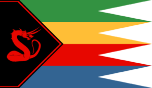
The Unitary Republic of North Umetuč (Tokagebač: Ւմետւճ [u.ˈmɛ.tʼut͡ʃ]) is a unitary autoritarian parliamentary republic on the northern edges of the continent of Kitkras in Sonhel. It takes its name from the island of Umetuč, of which it occupies the northern part. The current territories occupied by the Republic of North Umetuč were firstly settled in the 10th century by the nomadic tribes who will later adopt the names of Tokagebač, Cruiniiral and Valtarans. Umetuč shares the island with the Kingdom of Nova Albion to the south, which controls the central part of the island.
The Unitary Republic of North Umetuč Mesa Umetučobe Nekjagoxo Nekekra | |
|---|---|
| Motto: | |
| Anthem: Ube D̨ugoxočeb (The Red House) | |
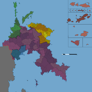
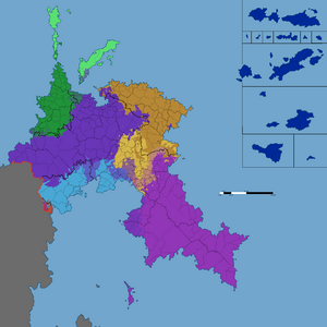
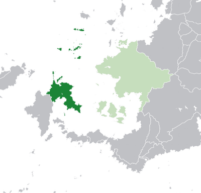 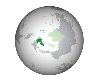 Map of North Umetuč in 2416 | |
| Capital | Tålakjemeqa (Տօլակյեմեհա) |
| Largest city | Tålakjemeqa |
| Official languages | Tokagebac |
| Recognised national languages | Tokagebač, Xopukuli, Mtàd Tokagebač |
| Recognised regional languages | Tokagebač, Cruiniiral, Ax tot Yonn, Dj̆ty, Xopukuli, Muippelore, Mtàd Tokagebač, Dïkïnns |
| Ethnic groups | Tokagebac, Xopukuli, Mtàd Tokagebac, Cruiniiral, Ax tot Yonn, Dj̆ty, Muippelore, Valtarans, Dïkïnns |
| Demonym(s) | Umetučite, Tokagebač |
| Government | Autoritarian parlamentary federal republic |
• President | Slabjo Čiček |
| Legislature | North Umetǔcite Parliament |
| Establishment | |
• Establishemnt of the Kingdom of Greater Ngenceba | 2361 |
• Unification of the United Heptamates of Greater Ngenceba, Xirakekunnae and C'aarllaac | 2389 |
• Intervention in the Valtaran Civil War and establishment of the United Republics of North Umetuč | 2403 |
• Establishment of the Unitary Republic of North Umetuč | 2410 |
| Population | |
• Estimate | 32 million |
• Density | 24/km2 (62.2/sq mi) |
| GDP (nominal) | estimate |
• Total | 118.6 billion ₦ (6 billion US$) |
| HDI | 0.5 low |
| Currency | Nekjagod (₦) (1US$ = 1788₦) |
| Date format | DD/MM/YYYY |
| Driving side | right |
History
Prehistory
The first signs of civilization in North Umetuč date back to the late 10th century. Around this time are said to belong the first settlements and metal tools found in the regions around the B̨obočim river. These findings are thought to belong to the first Tokagebac inhabitants of the island and that are thought to have originated in the valley around the Gnawing Gulf. Not much more informations are available regarding this era of Umetuč's history, apart form the fact that, according to analyzes conducted by the Tålakjemeqa Archeology Department, the communities inhabiting these dwellings used to construct them out of loose rocks and wes common practice use them during the cold months just to return to a seminomadic lifestyle once summer arrived. These tiny stone huts are still present on the territory and are called by the local Tokagebč population Pagjabra (Tokagebač: Պագյաբռա [p'ä.kjä.prä]). The first written accounts recovered on the west side of the mountains are dated to the late 12th century and are written in an unknown language, possibly an old extinct Brogåd language related to modern Tokagebač. The most relevant of these finds is a clay tablet dug up in the sorroundings of the modern city of Dičod̨o along the ruins of a large pagjabra village. The first evidence of organized communities in this regions came from the early 13th century with the finding of an old document inscripted on a paper-like material in a large ruined building on the side of the mountain range. This document is thought to be some kind of religious document due to its peculiar location. In this period is also thought to begin the expansion of the Tokagebač southwards. In 2378 were recovered, in a field west of Totoglat, several bronze weapons and armor pieces along as several isolated pagjabras encircling this supposed 2,5 km² battle ground. The equipment found in this region was classified in two distinct groups based on material and design: Tokagebač and Cruiniiral. This is the first piece of evidence backing the theory of the Cruiniiral's nativity to the Umetuč island.
Early Kingdoms and migrations
According to the TAD, the first Tokagebač and Cruiniiral kingdoms were established in the middle of the 16th century along the northern coasts of the island as well as remote regions across the mountains. These kingdoms were in constant war and competed with each other for resources and hegemony over the sorrounding tribes. This situation was escalated by a massive migration of Alftheimn sailors that came from the south-east and decided to settle on the eastern coast of the island. These groups of firstly settled in uninhabitaed valleys north of the mountains but later decided to expand to the south, engaging smaller and weaker Tokagebač villages and kingdoms in battle and raiding stronger settlements and communities. Another important migration came from the Syrovohan islands in the south. These immigrants spoke a language belonging to the Autrosyrovohic family and its only descendent, Dƿty, is related to the Lichrenean languages. Like their northen counterparts, the Syrovohan settelers began to raid and pillage the Tokagebač natives and expanded around the Belly Gulf coast.
Tokagebač Hegemony
From written accounts and archeological findings, we can confidently say that, since the second half of the 19th century, the Kingdom of G̨enečeban, which was a form of proto-federal entity where a single monarch (Tokagebač: Եպտամատե /ɛp't'ämät'/) ruled over many vassal and tributary states, had imposed itself as the leading military power in the area of the Gnawing Gulf. G̨enečeban had vassalized several small kingdoms and had defeated in war the Cruiniirals several times in the previous decades. At the same time, G̨enečeban had also established economic relations with the Xopukuli kingdoms in the east and began to gradually aquire more influence and respect among their ruling class. The most relevant market they shared was the Xopukuli weapons market, which funded the G̨enečeban war effort against their Cruiniiral rivals who, since the first contact with the Tokagebač, have always fought for land, resources and hegemony in the western areas of the island. This relationships between the Tokagebač and the Xopukuli solidified over the decades and mutated into a kind of simbiotic relationship where, while the Tokagebač continued their expansion in the south and conflicts in the west, the Xopukuli managed to export their culture and traditions to the point where G̨enečeban embraced Delusional Amarianism and popularized among the Tokagebač elite and spreading it to the civilian population and in the growing Mtàd population.
Geography
Umetuč is located on the northern half of the main island of the Tumetuč Archipelago, called Umetuč. The country is split in two sides by the Čytmekjem mountan range. The highest peak inside Umetučite border is the Ubebro mountain which stands at around 5100 meters in the northern regions of the country. The Ubebro is also the source of the only river in the Umetuč island: the B̨obočim, which untimately flows in the Gnawing Sea (the area of the ocean between the minor Axtyonn Umetuč Islands and the Gnawing Gulf) splitting the capital Tålakjemeqa in half. North Umetuč is located north of the equatorial belt and is therefore mostly covered in thick rainforests and savannas from the Gnawing Guld to the southern tip of the island. It also includes, in its western regions, a small chunk of sandy desert and dry regions that covers the western coasts of the island. Normally North Umetuč experiences a wet and hot season, which lasts between three and four months, along a colder season, in which precipitaion are slightly less abundant and average temperatures decrease by a few degrees.
Politics and government
North Umetuč was a federal parlamentary republic founded in 2402 after the collapse of the Valtaran States in the Valtaran Civil War. It includes the Region of Greater G̨enseba, the Region of Xirakekunnae, the Region of C'aarllaac and the Region of New Miše. In 2410 North Umetucà became a centralized republic with a unitary government, transforming the previous member republics in autonomous regions. Each of the regions have their own local bicameral parliament which has to enforce federally appproved laws and directives or has the possibility to contest them and have them adapted to their territory. The republics can also enforce exclusive laws that do not conflict with already approved federal laws and that do not regard economic policies, law and order, foreign politics, production and industrial projects and national defense. The federal government, composed of the president (which since 2405 also holds executive power) and of the bicameral parliament formed by elected representatives from the republics, is a supernational entity and has the power to impose laws and rules on the republics. The parliament is elected every four years with a proportional popular vote. The president is later elected by the two chambers of parliament every five years. The parliament can depose the current president and replace them thanks to a vote of no confidence that requires two thirds of both chambsers to pass. The president can disbandle one of the two chambers of parliament with a vote that needs 80% of the votes from the other parliament chamber.
Military
The Umetuč Armed Forces are split between Field Army and Navy. Both these entities are controlled by the national government but are internally administrated by generals and admirals elected by parliament every six years.
Foreign relations
North Umetuč is a founding member of the Amarian Combine and is currently its leader. It also is a founding member of the Transnational Assembly, association from which Umetuč has been pregressively less prominent and enthusiastically participant in. North Umetuč is a member of the Northern Economic Zone since 2407 and has created tight economic, political and cultural relations with its members.
Economy
Umetuč is an industrialized nation with a triving mining industry and weapon production sector. As of 2411, Umetuč has an employement rate of around 80% thanks to its interventionist policies and its ban on private enterprises, generating a GDP of about 6000 billion ₦. The government has virtually full control over the primary and secondary secotrs of th ecountry and has liberalized mostly the retail, communication and turism sectors. Freelance work is also accepted in Umetuč as long as its declared to and approved by the government, which makes sure it is taxed appropriately.
Energy
Most of the Energy production in Umetuč comes from its rich coal mines and fossil fuel deposits scattered all over the country. Each region has access to several mines and refinery stations capable of producing several thousands tons of coal yearly, which are than shipped to the rest of the country to power most of its industrial apparatus. Some of the largest cities are almost entirely powered by coal implants that produce a moderate amount of electricity.
Industry
North Umetuč is a fairly industrialized nation. It's most developed sectors are: common and rare metals extraction and refinery, artillery and weapon production, asphalt and concrete production, chemical manufacturing, glass manufacturing. These sectors are more developed than others thanks to the specific resources and minerals available inside Nort Umetuč's borders. Along these industries, North Umetuč has a fairly developed timber and fishing industry. Due to the dense raiforests and overall inhospitable terrain and poor soil, intensive agriculture is not a very remunerating area.
Demographics
North Umetuč is home to several ethnic groups and communities. The most prominent and numerous of these are the Tokagebač and the Mtàd Tokagebač, native to the northern areas of the island. The two Tokagebač groups have always been collaborating since the recent (late 23th century) split from which the Mtàd split from their north-western cousins. Some scholars argue that the linguistic differences between these communities are irrelevant and that the Tokagebač and the Mtàd are actually still part of the same ethnic cathegory. Another Indigenous group is the Cruiniiral, native to the north-western coast of the country. Unlike the Tokagebač, the Cruiniiral diverged into two separate groups back in the early 20th century, event from which the Ax Tot Yonn, who inhabited the Axtyonn Islands, were born. These two groups have always been in conflict with the Tokagebač nations since the early days of their existance but were ultimately defeated and assimilated into Tokagebač society after the Second Cruiniiral War (2361-2366). Another native minority in the west of the country is the Valtarans, a previously prosperous and numerous community that, after the fall of the Valtaran States after the Valtaran Civil War of 2403, is now reduced to a small community mostly inhabiting the city of Lambracaia (Tokagebac: Լամեբռագյա [lä.mɛ.ˈprä.kjä]; Valtaran: Lambracaia [lam.bɾa.ˈka.ja]) and the sorrounding areas.
Education
National standardized mandatory (from 6 to 16 years of age) education has been introduced by the Mepodo administration in 2404. Until then, children recieved a local education from their parents or some kind of municipal or provincial education program which was also completely optional. Not many were able to read or write and this negatively effected the economy of the country. The new school system of North Umetuč teaches children the national language, the history of their country and has the goal of creating an Umetučite national identity.
Religion
The most widespread religious belief in North Umetuč is the Cult of the Insane One (or Akixokukfyr Cult or Delusional Amarianism). The Cult of the Insane One is an unorthodox sect related to the Tarahanic religions that was imported in the Tumetuč archipelago by Alftheimnish sailors. Other minor religions and cults are the traditionalist Cruiniiral Vail, animist religions that worship natural forces related to the sea, teh jungle and the desert.
Culture
Umetučite culture is a melting pot of the various customs and ideas brought by the several cultures that live within its borders and its, for this reason, extremely diverse from region to region and even from city to city. Most of the values of strength of mind, courage and perceverence that the Umetučite population values and respects were brought by the Tokagebač warrior culture while most habits and practives were incorporated and popularized by Terahanic immigrnats. The Cruiniirals, due to the antagonistic role they were assigned for most of their history, had a marginal role in the construction of Umetučite culture mostly limited to architectural and naval engineering techniques. After the industrial revolution, the umetučite population developed a strong and long lasting fascination for technology and its potential applications and uses. This new cultural phenomenon manifested in many political and artistic movements which praysed war and violence manifested through war machines and mechanical weapons.
