Fairy Mountains: Difference between revisions
Jump to navigation
Jump to search
No edit summary |
No edit summary |
||
| Line 4: | Line 4: | ||
| etymology = Place where the fairies & goddess life | | etymology = Place where the fairies & goddess life | ||
| native_name = Sléibhte Sióg, Ævintýrafjöll | | native_name = Sléibhte Sióg, Ævintýrafjöll | ||
| native_name_lang = [[Götaish Language|Götaish]], | | native_name_lang = [[Götaish Language|Götaish]], {{wpl|Irish Language|Meallaigian}} | ||
| photo = | | photo = File:Mount Rainier from west.jpg | ||
| photo_size = 300px | | photo_size = 300px | ||
| photo_alt = | | photo_alt = | ||
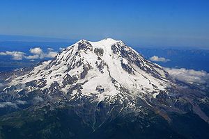
| photo_caption = | | photo_caption = Aerial photo of Mount Eefje | ||
| map = | | map = | ||
| map_image = | | map_image = | ||
| Line 18: | Line 18: | ||
| label = | | label = | ||
| label_position = | | label_position = | ||
| highest = [[ | | highest = [[Eefjefjall]] | ||
| elevation = | | elevation = | ||
| elevation_m = | | elevation_m = 3980 | ||
| elevation_ft = | | elevation_ft = | ||
| elevation_ref = | | elevation_ref = | ||
| prominence = | | prominence = | ||
| Line 43: | Line 43: | ||
| age = 108 million years | | age = 108 million years | ||
| geology = | | geology = | ||
| volcanic_arc = | | volcanic_arc = [[Lóthrdach Volcanic Arc|Lóthrdach]] | ||
| volcanic_belt = | | volcanic_belt = | ||
| volcanic_field = | | volcanic_field = | ||
| Line 56: | Line 56: | ||
}} | }} | ||
The '''Fairy Mountains''' ([[Götaish Language|Götaish]]: | The '''Fairy Mountains''' ({{wpl|Irish Language|Meallaigian}}: Sléibhte Sióg & [[Götaish Language|Götaish]]: Ævintýrafjöll) is a {{wpl|mountain range}} Eastern [[Argis]] stretching some 265 miles (427 km) from north to south across [[Gotneska]]. Reaching a peak elevation of 13,060 feet (3,980 m) on [[Eefjefjall]]. | ||
==Peaks== | ==Peaks== | ||
* [[Eefjefjall]] 3,980 m | |||
==History== | ==History== | ||
| Line 65: | Line 65: | ||
==Paleontology== | ==Paleontology== | ||
{{Eurth}} | |||
{{Template:Gotneska topics}} | |||
[[Category:Gotneska]] | |||
Latest revision as of 18:10, 4 October 2023
| Fairy Mountains | |
|---|---|
| Mountains of Fairies & Goddess's | |
 Aerial photo of Mount Eefje | |
| Highest point | |
| Peak | Eefjefjall |
| Elevation | 3,980 m (13,060 ft) |
| Naming | |
| Etymology | Place where the fairies & goddess life |
| Native name | Sléibhte Sióg, Ævintýrafjöll |
| Geography | |
| Location | Gotneska |
| Geology | |
| Age of rock | 108 million years |
| Volcanic arc | Lóthrdach |
The Fairy Mountains (Meallaigian: Sléibhte Sióg & Götaish: Ævintýrafjöll) is a mountain range Eastern Argis stretching some 265 miles (427 km) from north to south across Gotneska. Reaching a peak elevation of 13,060 feet (3,980 m) on Eefjefjall.
Peaks
- Eefjefjall 3,980 m