Muladic Inland Sea: Difference between revisions
Jump to navigation
Jump to search
 This Eurth-related article is a stub.
(Created page with "{{Infobox body of water | name = Muladic Inland Sea | native_name = | native_name_lang = | image = File:Muladic Inland Sea.png | alt = | caption = The boundaries of the Mul...") |
m (+stub) |
||
| (One intermediate revision by the same user not shown) | |||
| Line 16: | Line 16: | ||
| type = | | type = | ||
| inflow = | | inflow = | ||
| rivers = Periya Eri Estuary, Nupasha River <ref>Other smaller rivers and estuaries come off of the sea, however are not mentioned. (PDF) Retrieved 2nd July 2022</ref> | | rivers = Periya Eri Estuary, Nupasha River <ref>Other smaller rivers and estuaries come off of the sea, however are not mentioned. (PDF) Retrieved 2nd July 2022.</ref> | ||
| outflow = | | outflow = | ||
| catchment = | | catchment = | ||
| Line 43: | Line 43: | ||
}} | }} | ||
'''The Muladic Inland Sea''' ({{wp|Tamil|Ramil}}:Mulāṭik uḷnāṭṭu kaṭal) is the northernmost sub-sea within the [[Menelassar Bay]], bordering [[Kotowari]] and [[Tamurin]]. | {{Eurth stub}} | ||
'''The Muladic Inland Sea''' ({{wp|Tamil|Ramil}}: Mulāṭik uḷnāṭṭu kaṭal) is the northernmost sub-sea within the [[Menelassar Bay]], bordering [[Kotowari]] and [[Tamurin]]. | |||
==Etymology== | ==Etymology== | ||
==History== | ==History== | ||
| Line 50: | Line 53: | ||
{{reflist}} | {{reflist}} | ||
[[Category:Kotowari]] | [[Category:Kotowari]] | ||
{{Eurth}} | |||
Latest revision as of 11:46, 30 January 2024
| Muladic Inland Sea | |
|---|---|
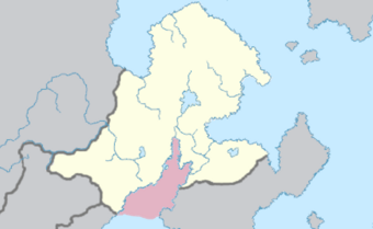
 The boundaries of the Muladic Inland Sea | |
| River sources | Periya Eri Estuary, Nupasha River [1] |
| Basin countries | Kotowari and Tamurin |
The Muladic Inland Sea (Ramil: Mulāṭik uḷnāṭṭu kaṭal) is the northernmost sub-sea within the Menelassar Bay, bordering Kotowari and Tamurin.
Etymology
History
Geography
References
- ↑ Other smaller rivers and estuaries come off of the sea, however are not mentioned. (PDF) Retrieved 2nd July 2022.