The Angle: Difference between revisions
mNo edit summary |
m (1 revision imported) |
Latest revision as of 14:17, 31 January 2019
The Angle
An tUilinn | |
|---|---|
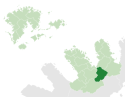
 The Angle (dark green) in Maltropia (light green) | |
| Capital | Mullach Círe |
| Area | |
| • Total | 122,744.86 km2 (47,392.06 sq mi) |
| Population | |
| • Total | 6,103,296 |
| • Density | 49.72/km2 (128.8/sq mi) |
| Demonym | Anglian |
The Angle (Irish: An tUilinn, meaning "the Angle" or "the Elbow") is a principality in Maltropia. With a population of 6,103,296 it is Maltropia's sixth-least populous principality. It is the eighth largest principality by area, at 122,745 square kilometres. The Angle is the least densely-populated principality in mainland Maltropia, with fewer than fifty people per square kilometre. Its capital is Mullach Círe.
The Angle straddles the divide between east and west Maltropia. It borders Tyrmidra and Fearann Ard in the west, Snowheight in the south, Espin in the east and Montrose in the north. It is characterised by a mountainous topography which it shares with its neighbours, with the Ardawns being the main mountain range. The city of Lisdare lies on the Angle's only section of coastline, a narrow strip at the head of Lisdare Fjord.

