Inner Besmenian border: Difference between revisions
Jump to navigation
Jump to search
Hierophant (talk | contribs) No edit summary |
m (Text replacement - "Trissia" to "Tergau") |
||
| (7 intermediate revisions by one other user not shown) | |||
| Line 1: | Line 1: | ||
{{Infobox military installation | {{Infobox military installation | ||
| name = Besmenian | | name = Inner Besmenian border | ||
| ensign = | | ensign = | ||
| ensign_size = | | ensign_size = | ||
| native_name = | | native_name = Innerbesmenische Grenze | ||
| partof = <!-- for elements within a larger site --> | | partof = <!-- for elements within a larger site --> | ||
| location = | | location = | ||
| nearest_town = <!-- used in military test site infobox --> | | nearest_town = <!-- used in military test site infobox --> | ||
| country = | | country = | ||
| image = Besmenian border 1937.jpg | | image = Besmenian border 1937.jpg | ||
| alt = | | alt = | ||
| caption = Border between Jakartaburg and | | caption = Border between Jakartaburg and Summingia in 1939 | ||
| image2 = <!--secondary image, major command emblems for airfields --> | | image2 = <!--secondary image, major command emblems for airfields --> | ||
| alt2 = | | alt2 = | ||
| Line 17: | Line 17: | ||
| coordinates = <!-- {{Coord}} --> | | coordinates = <!-- {{Coord}} --> | ||
| gridref = | | gridref = | ||
| image_map = Map of divided | | image_map = Map of divided Besmenia2.png | ||
| image_mapsize = 188px | | image_mapsize = 188px | ||
| image_map_alt = | | image_map_alt = | ||
| Line 53: | Line 53: | ||
| past_commanders = <!-- past notable commander(s) --> | | past_commanders = <!-- past notable commander(s) --> | ||
| garrison = West: | | garrison = West: | ||
* {{flagicon|Besmenian Empire}} [[Besmenian Royal Army]] | * {{flagicon|Besmenian Empire}} [[Besmenian Royal Army (1921-1966)|Besmenian Royal Army ]] | ||
* {{flagicon|Besmenian Empire}} [[Border troops of the Royal Army]] | * {{flagicon|Besmenian Empire}} [[Border troops of the Royal Army]] | ||
* {{flagicon|Besmenian Empire}} [[State Security of Besmenia]] | * {{flagicon|Besmenian Empire}} [[State Security of Besmenia]] | ||
| Line 63: | Line 63: | ||
| footnotes = <!-- catchall in case it's needed to preserve something in infobox that doesn't work in new code --> | | footnotes = <!-- catchall in case it's needed to preserve something in infobox that doesn't work in new code --> | ||
}} | }} | ||
The '''Besmenian | The '''Inner Besmenian border''' (Besmenian: Innerbesmenische Grenze) was the border between the [[Besmenian Empire|West Besmenia]] and [[East Besmenia]]. The border was blocked and guarded by the West Besmenian side in the spring of 1926. The reason was the [[Economic miracle in East Besmenia]], which also resulted that many residents moved from West Besmenia to East Besmenia. On June 13, 1966 the border was reopened and dismantling began. | ||
The border guards of the Royal Army which monitored the border had the order to shoot. As a result, border refugees died repeatedly | The border guards of the Royal Army which monitored the border had the order to shoot. As a result, border refugees died repeatedly. | ||
The Besmenian | The Inner Besmenian border has long been considered as the one of the most dangerous border in [[Iearth]]. | ||
==Development== | ==Development== | ||
==Deaths of border refugees== | ==Deaths of border refugees== | ||
| Line 73: | Line 73: | ||
==Gallery== | ==Gallery== | ||
<center><gallery> | <center><gallery> | ||
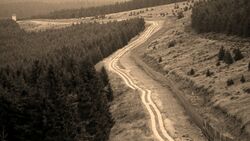
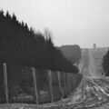
File: Besmenian Border Zone1.jpg|Border between | File: Besmenian Border Zone1.jpg|Border between Sedakania and Tergau in January 1953. | ||
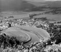
File: Besmenian Border Zone2.jpg|A small village in | File: Besmenian Border Zone2.jpg|A small village in East Besmenia that is at the border to West Besmenia (1956). | ||
File: Besmenian Border Zone3.jpg|A border tower at the border between | File: Besmenian Border Zone3.jpg|A border tower at the border between South Lemberland and Neidenstein-Sulzburg (1947). | ||
</gallery></center> | </gallery></center> | ||
[[Category: Besmenia]] | [[Category: Besmenia]] | ||
Latest revision as of 20:31, 31 March 2023
| Inner Besmenian border | |
|---|---|
Innerbesmenische Grenze | |
 Border between Jakartaburg and Summingia in 1939 | |
| File:Map of divided Besmenia2.png | |
| Site information | |
| Controlled by | |
| Condition | Mostly demolished, some parts preserved for historic record |
| Site history | |
| Built | 1926 |
| In use | 1926-1966 |
| Events | Besmenian division |
| Garrison information | |
| Garrison | West:
East: |
The Inner Besmenian border (Besmenian: Innerbesmenische Grenze) was the border between the West Besmenia and East Besmenia. The border was blocked and guarded by the West Besmenian side in the spring of 1926. The reason was the Economic miracle in East Besmenia, which also resulted that many residents moved from West Besmenia to East Besmenia. On June 13, 1966 the border was reopened and dismantling began.
The border guards of the Royal Army which monitored the border had the order to shoot. As a result, border refugees died repeatedly.
The Inner Besmenian border has long been considered as the one of the most dangerous border in Iearth.


