Rees: Difference between revisions
No edit summary |
No edit summary |
||
| (7 intermediate revisions by 3 users not shown) | |||
| Line 1: | Line 1: | ||
[[Category:Estmerish towns]]{{Infobox settlement | {{KylarisRecognitionArticle}} [[Category:Estmerish towns]]{{Infobox settlement | ||
|name = Rees | |name = Rees | ||
|native_name = '' | |native_name = ''Riis'' | ||
|native_name_lang = | |native_name_lang = | ||
|settlement_type = Parish | |settlement_type = Parish | ||
| Line 109: | Line 109: | ||
}} | }} | ||
'''Rees''' (pronounced {{IPAc-en|ˈ|r|iː|s}}, {{wp|Frisian language|Dellish}}: '' | '''Rees''' (pronounced {{IPAc-en|ˈ|r|iː|s}}, {{wp|Frisian language|Dellish}}: ''Riis'', also known as '''West-Riis''' or '''West Rees'''), is a parish and town of [[Estmere]], located in [[Counties of Estmere|the Perch]] and the [[States of Estmere|state]] of [[Arvorne]]. The town is sistered with [[Riis|Oost-Rijs]], with which it shares a complicated border that both towns are known for. It is also famous for hosting the Rock'nRiis festival along with its Hennish sister town, with the festival main stage usually straddling the border of the two countries. The town consists primarily of a number of Estmerish {{wp|exclaves}} surrounded by [[Hennehouwe]]. It had a population of 4,389 in 2015. | ||
==Geography== | ==Geography== | ||
===Border with Oost-Rijs=== | ===Border with Oost-Rijs=== | ||
[[File:Rees-Rijs-Riis enclave map.svg|left|300px|thumb|Estmerish and Hennish territory in Rees/Rijs/Riis]]Rees is closely linked to [[Oost-Rijs]]. It shares a complicated border with the neighbouring town, for which it is known. The parish and town consists of 16 separate areas of land, all but one of which are Estmerish {{wp|exclaves}} within [[Hennehouwe]]. There are also 12 Hennish exclaves, 6 of which are {{wp|Enclaves within enclaves|counter-exclaves}} within Estmerish exclaves and 6 of which are surrounded by Estmere proper. | [[File:Rees-Rijs-Riis enclave map.svg|left|300px|thumb|Estmerish and Hennish territory in Rees/Rijs/Riis]]Rees is closely linked to [[Riis|Oost-Rijs]]. It shares a complicated border with the neighbouring town, for which it is known. The parish and town consists of 16 separate areas of land, all but one of which are Estmerish {{wp|exclaves}} within [[Hennehouwe]]. There are also 12 Hennish exclaves, 6 of which are {{wp|Enclaves within enclaves|counter-exclaves}} within Estmerish exclaves and 6 of which are surrounded by Estmere proper. | ||
The incredibly complex border is a result of centuries of conflicting treaties, charters, agreements and land-swaps that took place in the area, generally between the Dukes of [[Counties of Estmere|the Perch]], the [[Solarian Catholic Church|Bishops of Barfleu]] and the lords of [[Lower Stegeren]]. The borders were somewhat simplified by the [[Amendist Wars#Peace of Frankendorf|Peace of Frankendorf]], but it wasn't until the [[Estmere#History|Treaty of Eternal Amendist Friendship]] between the [[Sotirian Commonwealth]] and the [[Kingdom of Estmere]] in 1646 that the borders were formalised. The current arrangement of the borders was then clarified and further simplified in 1747 as part of the [[Estmerish-Hennish War#Treaty of Verlois|Treaty of Verlois]] which ended the [[Estmerish-Hennish War]]. In 1926 as part of the [[Hennehouwe Crisis]] leading up to the [[Great War (Kylaris)|Great War]], Estmere refused to allow [[Functionalist Gaullica|Gaullican forces]] to advance into the Hennish exclaves in Estmere proper. The exclaves therefore became a haven for Hennish refugees fleeing northwards. | The incredibly complex border is a result of centuries of conflicting treaties, charters, agreements and land-swaps that took place in the area, generally between the Dukes of [[Counties of Estmere|the Perch]], the [[Solarian Catholic Church|Bishops of Barfleu]] and the lords of [[Lower Stegeren]]. The borders were somewhat simplified by the [[Amendist Wars#Peace of Frankendorf|Peace of Frankendorf]], but it wasn't until the [[Estmere#History|Treaty of Eternal Amendist Friendship]] between the [[Sotirian Commonwealth]] and the [[Kingdom of Estmere]] in 1646 that the borders were formalised. The current arrangement of the borders was then clarified and further simplified in 1747 as part of the [[Estmerish-Hennish War#Treaty of Verlois|Treaty of Verlois]] which ended the [[Estmerish-Hennish War]]. In 1926 as part of the [[Hennehouwe Crisis]] leading up to the [[Great War (Kylaris)|Great War]], Estmere refused to allow [[Functionalist Gaullica|Gaullican forces]] to advance into the Hennish exclaves in Estmere proper. The exclaves therefore became a haven for Hennish refugees fleeing northwards. | ||
In 1939 the Estmerish and Hennish governments attempted to remove the exclaves and establish a single border, but this was opposed by townsfolk on both sides of the border who refused to move or relinquish citizenship of either side. Instead, a limited treaty allowing for {{wp|freedom of movement}} was signed. The two countries went on to found the [[Euclean Community]] in 1948, and the establishment of Euclea-wide free movement as part of the [[Euclean Community#Zilverzee Area|Zilverzee Area]] in 1983 considerably simplified the situation. There remain some irregularities, such as many buildings constructed after 1983 crossing over the border. | In 1939 the Estmerish and Hennish governments attempted to remove the exclaves and establish a single border, but this was opposed by townsfolk on both sides of the border who refused to move or relinquish citizenship of either side. Instead, a limited treaty allowing for {{wp|freedom of movement}} was signed. The two countries went on to found the [[Euclean Community]] in 1948, and the establishment of Euclea-wide free movement as part of the [[Euclean Community#Zilverzee Area|Zilverzee Area]] in 1983 considerably simplified the situation. There remain some irregularities, such as many buildings constructed after 1983 crossing over the border. | ||
==Local government== | |||
The governance of Rees is the responsibility of the Rees parish council, which is led by a mayor. The mayor has been Gerbren van der Lei of the [[Sotirian Democratic Union]] since 2008. As a parish, Rees parish has limited powers, in the areas of traffic, urban planning and festivals. Rees parish is part of the district of [[Districts of Estmere|West Perch]], in the county of [[Counties of Estmere|the Perch]], in the state of [[Arvorne]]. The parish is a ward constituency in [[Districts of Estmere|West Perch District Council]] electing 3 councillors. It is part of the federal constituency of [[Parliament of Estmere#Constituencies|Perch West]]. | |||
==Demographics== | |||
The parish had a population of 4,389 according to the 2015 census. {{wp|Frisian language|Dellish}} is the most common first language in the parish, but {{wp|English language|Estmerish}} is also widely spoken as a second language. {{wp|Dutch language|Hennish}} is also spoken by a significant minority. The local dialect shared with [[Riis|Oost-Rijs]] is a form of {{wp|code-switching}} with a mixed {{wp|jargon}} known as ''Riis-speak'' (Dellish: ''Riispraat'', Hennish: ''Rijspraat''), which combines elements from all three languages. | |||
==Notable people== | ==Notable people== | ||
* [[Rees#Notable people|Aaiolt de Beer]] (1513–1572) Estmerish playwright | * [[Rees#Notable people|Aaiolt de Beer]] (1513–1572) Estmerish playwright | ||
* [[Tristan Gardner]] (born 1972) Estmerish politician, | * [[Tristan Gardner]] (born 1972) Estmerish politician, former leader of the [[Sotirian Democratic Union]] | ||
==Sister towns== | ==Sister towns== | ||
Rees is twinned with one {{wp|Sister city|sister town}}, the Hennish municipality of [[Oost-Rijs]] which surrounds most of Rees. The two towns always shared close ties, and officially twinned in 1955. | Rees is twinned with one {{wp|Sister city|sister town}}, the Hennish municipality of [[Riis|Oost-Rijs]] which surrounds most of Rees. The two towns always shared close ties, and officially twinned in 1955. | ||
*{{flagicon|Hennehouwe}} [[Oost-Rijs]], Hennehouwe, 1955 | *{{flagicon|Hennehouwe}} [[Riis|Oost-Rijs]], Hennehouwe, 1955 | ||
==Gallery== | ==Gallery== | ||
<gallery mode=packed> | <gallery mode=packed> | ||
File:Glastonbury (part of) from the tor arp.jpg|View of Rees and [[Oost-Rijs]] from the | File:Glastonbury (part of) from the tor arp.jpg|View of Rees and [[Riis|Oost-Rijs]] from the Hennish side of the border | ||
File:St. John's Church, Glastonbury, Somerset, England arp.jpg|Church of St Anthony | File:St. John's Church, Glastonbury, Somerset, England arp.jpg|Church of St Anthony | ||
File:Huis Baarle.jpg|The border passing through a house | File:Huis Baarle.jpg|The border passing through a house | ||
File:Early Sunday afternoon crowd at the Pyramid (323784473).jpg|Main stage of the Rock'nRiis festival, 2008 | |||
File:Glastonbury town centre arp.jpg|Rees town centre during the summer | File:Glastonbury town centre arp.jpg|Rees town centre during the summer | ||
</gallery> | </gallery> | ||
==See also== | |||
*[[Riis|Oost-Rijs]] | |||
Latest revision as of 09:21, 14 August 2023
Template:KylarisRecognitionArticle
Rees
Riis | |
|---|---|
Parish | |
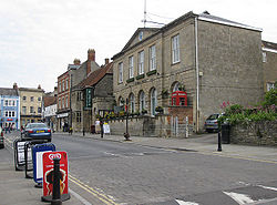 Rees town hall | |
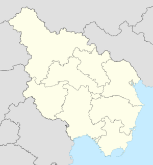
Location in Estmere | |
| Country | Estmere |
| State | Arvorne |
| County | The Perch |
| District | West Perch |
| Government | |
| • Body | Parish council |
| • Mayor | Gerbren van der Lei (SDU) |
| Population (2015) | |
| • Total | 4,389 |
| Postal code(s) | |
| Website | rees-west-riis |
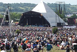
Rees (pronounced /ˈriːs/, Dellish: Riis, also known as West-Riis or West Rees), is a parish and town of Estmere, located in the Perch and the state of Arvorne. The town is sistered with Oost-Rijs, with which it shares a complicated border that both towns are known for. It is also famous for hosting the Rock'nRiis festival along with its Hennish sister town, with the festival main stage usually straddling the border of the two countries. The town consists primarily of a number of Estmerish exclaves surrounded by Hennehouwe. It had a population of 4,389 in 2015.
Geography
Border with Oost-Rijs
Rees is closely linked to Oost-Rijs. It shares a complicated border with the neighbouring town, for which it is known. The parish and town consists of 16 separate areas of land, all but one of which are Estmerish exclaves within Hennehouwe. There are also 12 Hennish exclaves, 6 of which are counter-exclaves within Estmerish exclaves and 6 of which are surrounded by Estmere proper.
The incredibly complex border is a result of centuries of conflicting treaties, charters, agreements and land-swaps that took place in the area, generally between the Dukes of the Perch, the Bishops of Barfleu and the lords of Lower Stegeren. The borders were somewhat simplified by the Peace of Frankendorf, but it wasn't until the Treaty of Eternal Amendist Friendship between the Sotirian Commonwealth and the Kingdom of Estmere in 1646 that the borders were formalised. The current arrangement of the borders was then clarified and further simplified in 1747 as part of the Treaty of Verlois which ended the Estmerish-Hennish War. In 1926 as part of the Hennehouwe Crisis leading up to the Great War, Estmere refused to allow Gaullican forces to advance into the Hennish exclaves in Estmere proper. The exclaves therefore became a haven for Hennish refugees fleeing northwards.
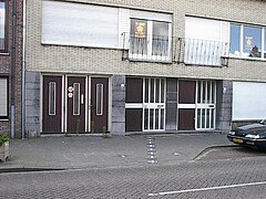
In 1939 the Estmerish and Hennish governments attempted to remove the exclaves and establish a single border, but this was opposed by townsfolk on both sides of the border who refused to move or relinquish citizenship of either side. Instead, a limited treaty allowing for freedom of movement was signed. The two countries went on to found the Euclean Community in 1948, and the establishment of Euclea-wide free movement as part of the Zilverzee Area in 1983 considerably simplified the situation. There remain some irregularities, such as many buildings constructed after 1983 crossing over the border.
Local government
The governance of Rees is the responsibility of the Rees parish council, which is led by a mayor. The mayor has been Gerbren van der Lei of the Sotirian Democratic Union since 2008. As a parish, Rees parish has limited powers, in the areas of traffic, urban planning and festivals. Rees parish is part of the district of West Perch, in the county of the Perch, in the state of Arvorne. The parish is a ward constituency in West Perch District Council electing 3 councillors. It is part of the federal constituency of Perch West.
Demographics
The parish had a population of 4,389 according to the 2015 census. Dellish is the most common first language in the parish, but Estmerish is also widely spoken as a second language. Hennish is also spoken by a significant minority. The local dialect shared with Oost-Rijs is a form of code-switching with a mixed jargon known as Riis-speak (Dellish: Riispraat, Hennish: Rijspraat), which combines elements from all three languages.
Notable people
- Aaiolt de Beer (1513–1572) Estmerish playwright
- Tristan Gardner (born 1972) Estmerish politician, former leader of the Sotirian Democratic Union
Sister towns
Rees is twinned with one sister town, the Hennish municipality of Oost-Rijs which surrounds most of Rees. The two towns always shared close ties, and officially twinned in 1955.
 Oost-Rijs, Hennehouwe, 1955
Gallery
View of Rees and Oost-Rijs from the Hennish side of the border
