Anagonia: Difference between revisions
Jump to navigation
Jump to search


| Line 101: | Line 101: | ||
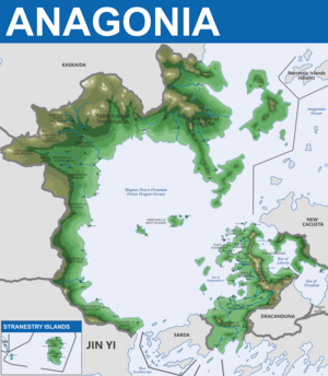
[[File:AnagoniaTopographicMapComplete2024(resized).png|thumb|left|Topographic Map of Anagonia <br> | [[File:AnagoniaTopographicMapComplete2024(resized).png|thumb|left|Topographic Map of Anagonia <br> | ||
Image circa 108 AUR <br> ''(Image Commissioned by Anagonia, Drawn by DSK circa 2024)'']] | Image circa 108 AUR <br> ''NOTE POST-GREAT WAR CHANGES'': <BR> * More Territory to Southwest of Mainland <br> * Annexation of Additional Islands <br> * Annexation of Conquered [[Kaskaida]] Territories''<br> (Image Commissioned by Anagonia, Drawn by DSK circa 2024)'']] | ||
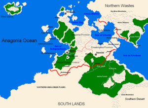
[[File:AnagoniaPREGWMapOLD.png|thumb|right|Pre-Great War Anagonia <br> ''(circa United Republic era | [[File:AnagoniaPREGWMapOLD.png|thumb|right|Pre-Great War Anagonia <br> ''(circa United Republic era - 1921 AD & prior)'' <br> ''NOTE THE THREE DISTINCT PROVINCES'': <br> | ||
* Anagonia Province <br> * Drekamythia Province <br> * Nodea Rudav Province]] | * Anagonia Province <br> * [[Drekamythia]] Province <br> * [[Nodea Rudav]] Province <br> The United Republic of Anagonia was a more federalized entity that combined the mainland Anagonia into one primary nation. It would eventually fall due to civil war in 1921 AD.]] | ||
==Biodiversity== | ==Biodiversity== | ||
Revision as of 22:46, 21 April 2024
This article is incomplete because it is pending further input from participants, or it is a work-in-progress by one author. Please comment on this article's talk page to share your input, comments and questions. Note: To contribute to this article, you may need to seek help from the author(s) of this page. |
The Confederate States of Anagonia Anagonia | |
|---|---|
| Motto: "Astra inclinant, sed nonobligant"
| |
| Capital | Liberty City |
| Largest city | Atlantica |
| Official languages | Native Anagonian & English |
| Recognised regional languages | Regional dialects dependent on State or Territory |
| Other languages | (Other European, Russian, Spanish, Other Asian, Various Non-Human Languages) |
| Ethnic groups (108 AUR) | Anagonian, Various others determined on state and territory |
| Demonym(s) | Anagonian(s), Confederate(s) |
| Government | Constitutional Republic |
• President | Mileethus Canisilus |
• Vice President | Franklin Johnson |
| Establishment | |
• XX | XX |
• XX | XX |
• XX | XX |
• XX | XX |
• XX | XX |
• XX | XX |
| Area | |
• Total | 21,864,400 km2 (8,441,900 sq mi) |
| Population | |
• 108 AUR estimate | 450,522,407 |
• Density | 5.77/km2 (14.9/sq mi) |
| GDP (nominal) | 108 AUR estimate |
• Total | D$28,424,257,741,025 |
• Per capita | D$78,246.01 |
| Gini | 0.43 low |
| HDI | 0.927 very high |
| Currency | Confederate DENAR (D$) |
| Time zone | UTC+5 (Anagonian Standard Time Zones) |
• Summer (DST) | UTC+6 (Anagonian Standard Time Zones) |
| Driving side | right |
| Calling code | 678 |
| Internet TLD | .CSA |
The Confederate States of Anagonia has:
| |
Introduction
History
Etymology
Geography and Climate
Geography

Topographic Map of Anagonia
Image circa 108 AUR
NOTE POST-GREAT WAR CHANGES:
* More Territory to Southwest of Mainland
* Annexation of Additional Islands
* Annexation of Conquered Kaskaida Territories
(Image Commissioned by Anagonia, Drawn by DSK circa 2024)
Image circa 108 AUR
NOTE POST-GREAT WAR CHANGES:
* More Territory to Southwest of Mainland
* Annexation of Additional Islands
* Annexation of Conquered Kaskaida Territories
(Image Commissioned by Anagonia, Drawn by DSK circa 2024)

Pre-Great War Anagonia
(circa United Republic era - 1921 AD & prior)
NOTE THE THREE DISTINCT PROVINCES:
* Anagonia Province
* Drekamythia Province
* Nodea Rudav Province
The United Republic of Anagonia was a more federalized entity that combined the mainland Anagonia into one primary nation. It would eventually fall due to civil war in 1921 AD.


