Kankiesi-Tos Dual Republic: Difference between revisions
No edit summary |
No edit summary |
||
| Line 19: | Line 19: | ||
|alt_map2 = <!--alt text for second map--> | |alt_map2 = <!--alt text for second map--> | ||
|map_caption2 = <!--Caption to place below second map--> | |map_caption2 = <!--Caption to place below second map--> | ||
|capital = [[Miséy]] | |capital = [[Miséy]] | ||
[[Kosken]] | |||
[[Îll Néy Hʟaʟ]] | |||
|largest_city = Eymon | |largest_city = Eymon | ||
|official_languages = Meskiyon | |official_languages = Meskiyon | ||
Revision as of 00:55, 5 September 2020
This article is incomplete because it is pending further input from participants, or it is a work-in-progress by one author. Please comment on this article's talk page to share your input, comments and questions. Note: To contribute to this article, you may need to seek help from the author(s) of this page. |
The Dual Kankiesi-Tos Republics Miléyke Kankiesia Tos Olnihʟaʟ | |
|---|---|
| Motto: Vilkéy Nif Xlanoh | |
| Anthem: "Ni Savelèy" | |
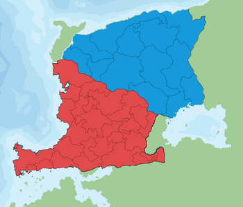
 A map of Etsenes, the red highlighted area is Kankiesk, while the blue is Tosn. | |
| Capital | Miséy Îll Néy Hʟaʟ |
| Largest city | Eymon |
| Official languages | Meskiyon |
| Recognized national languages | Veztokr, Alat |
| Recognized regional languages | Eneskezt, Fetkinyn, Kvaz, Oktap, Tevkot |
| Ethnic groups (1096 AKE) | Kankiesian, Tos |
| Demonym(s) | Tsenes, Kankiesian, Tos |
| Government | Dual Federal Republic |
• Leyont of Tosn | Nika Meyrel |
• Leyont of Kankiesk | Eriey Vernoff |
| Legislature | The Vekoz |
| The Elive | |
| The Meylon | |
| History | |
• The Arrival of Enesez Tribes in the highlands | 740 BKE (184 AD) |
• The Kantaket tribes break away and settle south in the lowlands | 717 BKE (207 AD) |
• Unification of Kankiesk and Tosn | 981 AKE |
| Area | |
• Total | 1,759,541 km2 (679,363 sq mi) |
| Population | |
• 1096 SR estimate | |
• 1093 SR census | |
• Density | 53.0/km2 (137.3/sq mi) |
| GDP (PPP) | estimate |
• Total | $58 832 |
| GDP (nominal) | 1096 SR estimate |
• Total | $5.4 Trillion |
| HDI (1096 AKE) | 0.883 very high |
| Currency | Tsenes Tsik |
| Date format | dd/mm/yyyy AKE |
| Driving side | left |
| Calling code | +18 |
| Internet TLD | .KT |
Etsenes, officially the Kankiesi-Tos Dual Republic (Meskiyon: Miléyke Kankiesia Tos Olnihʟaʟ) is a republic located in Katzen, situated between the Srzek Mountains in the East, Kios Tiklet (Tiklet Sea) in the west, the Tos highlands and eventually the Kios Nyetenl (Nyetenl Sea) in the north, the Kiosikn Ostrek in the south-west, and the Kiosin Tsikot in the south east with a small bridge into the interior of the continent in the south-central region.
Etymology
The name Etsenes (Ets/E/ns) has very unclear origins, but it is generally just the name of the area in which the modern day Kankiesi-Tos Dual Republics inhabits, which is why the nation is generally just called Etsenes rather than its ridiculously long official name.
In Meskiyon, Etsenes (Ets/E/ns) is actually pronounced "Itsenez" (E/ts/eh/neh/z), but much like in English, the demonyms for the two prominent sub-ethnic groups in the nation are the Kankiesians and the Tos, which are apart of the greater Tsenes (Meskiyon: Tsenz, Ts/eh/nz) ethnicity
History
Prehistory
It is highly unclear where they originated, but the arrival of the Enesez Tribes in 740 BKE (184 AD) marked the beginning of Tsenes Civilization. 23 years later, the tribal people split up, the Kantaket tribe migrating south into the lowlands, which provide fertile and easily colonizable land. The Enesez meanwhile stayed in the highlands and mountains, which provide rich natural defenses but poor soil, natural resources, and trade ability, forcing them to continue in their traditional ways of life, with little technological advancement. as the Kantaket tribes settled the lowlands and southern areas, they lived in peace with the natives for a short time, but due to disputes about territorial encroachment, the more advanced Kantaket tribes expelled the natives from the lands, forcefully moving them onto Pfet Island (the Pfet Peninsula at the time) in the north of the region, which being much smaller than the previously inhabited territory, did not have the animal population to support that many people, so the native creatures on the island died off at an alarming rate as the tribes hunt them for food. slowly, as the numbers dwindle, food becomes scarce and the expelled tribes begin war over food and resources to survive on. Causing many deaths and creating a just generally hostile, chaotic environment.
As time went on, the Enesez tribe had more breakups which saw two more waves of settlers moved south to assimilate with the Kantaket, who mostly accepted them into their developing society. Meanwhile the Enesez tribe discovered the northern coast of Etsenes and slowly migrated from the highlands onto that coast, leaving the highlands depopulated and mostly barren. This also left many very well preserved abandon Enesez settlements for later discovery. The issue with this migration is that this added only another level of isolation to the Enesez settlements, who as a result didn't urbanize their land very much compared to the Kantaket tribes.
The Kantaket began trade with other cultures around the year 703 BKE and became a recognizable group of people as a result, as the isolated Enesez kept to themselves much more and slowly built their own society on principles of isolation and harmony within their civilization.
Etsosn and Kenkaska
The tribes eventually developed into the much more civilized nations of Etsosn and the Kenkaska Kingdoms.
Kankiesi-Tos Dual Republic | |
|---|---|
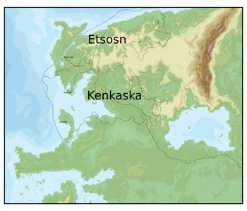
 A map of the middle ages borders, as well as trade routes and cities. |
Who despite being from the same lineage and being in close quarters with one another, always saw one another as rivals, bringing about centuries of war and conquest. Under King Yeskevot of the Hikov Dynasty, Kenkaska blocked trade from flowing into Etsosn from its borders in an attempt to weaken them, and this succeeded in hindering trade and the transportation of new ideas into Etsosn, while Kenkaska flourished and formed many large cities on the coast, which eventually became large ports for trading. Feudalism was installed within both nations which both had very large peasant populations. The Royals had large, luxurious castles and cathedrals built for residing and worship, while the peasants had separate, smaller churches in which they would worship their beliefs, whatever they where. This was around the year 519 AD (405 BKR)
The Dark Ages of Kankaska
King Laemis II died around the year 844 AD (81 BKE) sparking a civil war of succession within Kankaska between Laemis III, his brother Eleméy I, and their cousin, Ménilas. This civil war brought about a dark age in which thousands died fighting for who they believed should be King or Queen. Eventually, Eleméy I won the war, but at the cost of thousands of lives and an even more unstable nation. Eleméy I ruled a ruined nation that was littered with constant rebellion and economic chaos. His son, Eleméy II, did even worse, who launched a war with neighboring Etsosn States, who promptly united against Kankaska to defend themselves, a move that everyone saw coming except Eleméy II. The war brought chaos in Northeastern Kankaska and caused even more rebellion. Eventually, A plague struck at the most inopportune time, flaring up all across Kankaska. This pushed the populace to their limit. Eleméy II was overthrown by his cousin, Liyven I, who eventually ended up being the father of the 1st Kankiesian Empire.
The 1st Kankas Empire
Liyven I easily crushed the remaining resistance for his cousin, Eleméy II. After that, he consolidated his power and, using the loyal soldiers of the Kankasian Military, invaded the territories that were annexed by the Etsosn States. They then went further and invaded the rest of Etsosn. Annexing much of the Tos territory and entirely reforming the borders of the area, creating 3 distinct Tos states rather than keeping the lot of them, which consisted of more than 55 independent Duchies and Kingdoms. He then turned his sights south to the southeastern plain, which had been a thorn in the side of Kankaska for centuries.
Unification of Kankiesk and Tosn
The 1st Kankiesian Civil War
The Post War Decades
Modern Day
Geography
Kankiesi-Tos Dual Republic | |
|---|---|
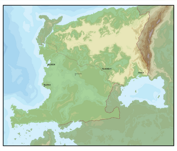
 Topographical Map of Etsenes with Major Cities |
Etsenes has a total area of 1,759,541 km2, (679,363 sq mi), which is a fairly large size considering the size of the continent in all. Etsenes has actually be blessed with near perfect geography, the Srzek mountains in the North-East largely protect the nation from outside invaders, and the North, West, Central-East and South are all flanked by coast, The only geographic weakness the nation is presented with is the South-Eastern plain, which funnels foreigners right up into the nations heartland: the Lowlands. As a result, the nation has sought protection for its South-Eastern border for most of its history. Due to the fact that there are no natural barriers near the nations South-Eastern borders, the nation's primary focus for centuries is to A. Build a military that is powerful enough to keep out any invader, and B. Put as much distance between this weakness and foreign empires as possible. As a result, the Kankiesians have built some of the largest empires in the history of the continent.
Climate
wip
Environment
wip
Politics and Government
wip

