Maucha: Difference between revisions
| Line 146: | Line 146: | ||
{{Largest cities | {{Largest cities | ||
| name = Largest cities in | | name = Largest cities in Maucha | ||
| country = | | country = Maucha | ||
| stat_ref = | | stat_ref = 2020 Census | ||
| list_by_pop = List of cities in | | list_by_pop = List of cities in Maucha | ||
| kind = cities | | kind = cities | ||
| class = nav | | class = nav | ||
| div_link = | | div_link = States of Maucha{{!}}Maucha | ||
| city_1 = | | city_1 = Nambabi | div_1 = Nambabi{{!}}''Nambabi C.S.'' | pop_1 = 2,514,214 | img_1 = DrosnjaIzmir.jpg | ||
| city_2 = | | city_2 = Garastadt | div_2 = Garastadt{{!}}''Garastadt C.S.'' | pop_2 = 1,805,664 | img_2 = Mersin Yenişehir shore.JPG | ||
| city_3 = | | city_3 = Kanyabahayadha | div_3 = Kanyabahayadha{{!}}''Kanyabahayadha C.S.'' | pop_3 = 1,156,782 | img_3 = Bassaniamarseille.jpg | ||
| city_4 = | | city_4 = Usambara | div_4 = Hëna County{{!}}Hëna | pop_4 = 710,746 | img_4 = Cernjatangier.jpg | ||
| city_5 = | | city_5 = Bomtili | div_5 = Valqëndrush County{{!}}Valqëndrush | pop_5 = 678,152 | ||
| city_6 = | | city_6 = Bangoli | div_6 = Kallëm County{{!}}Kallëm| pop_6 = 517,013 | ||
| city_7 = | | city_7 = Indwengwe | div_7 = Corchès County{{!}}Corchès | pop_7 = 489,357 | ||
| city_8 = | | city_8 = Ibabitema | div_8 = Sèngsagrát County{{!}}Sèngsagrát | pop_8 = 477,781 | ||
| city_9 = | | city_9 = Port Zimmermann| div_9 = Fillim County{{!}}Fillim | pop_9 = 432,776 | ||
| city_10 = | | city_10 = Amasufer | div_10 = Dxèrdxè County{{!}}Dxèrdxè | pop_10 = 343,979 | ||
}} | }} | ||
===Ethnicities=== | ===Ethnicities=== | ||
Revision as of 20:35, 9 December 2021
Democratic Republic of Maucha | |
|---|---|
| Motto: "Für die Menschen aus dem Land des Silbers" (For the poeple from the land of silver) | |
 | |
| Capital | Kanyabahayadha |
| Largest | Nambabi |
| Official languages | Weranic |
| Recognised national languages | |
| Demonym(s) | Mauchian |
| Government | Federative presidential republic |
• President | Werner Okonkwo |
• Vice President | Mavo Holomisa |
• President of Senate | Kalere Odili |
• President of the Chamber | Issa Mbadinuju |
| Legislature | National Congress |
| Senate | |
| House of Deputies | |
| Formation | |
| Population | |
• 2020 estimate | 30,955,202 |
| GDP (PPP) | 2020 estimate |
• Total | $100,542,496,096 (46th) |
• Per capita | $3,248 (56th) |
| GDP (nominal) | 2020 estimate |
• Total | $70,144,487,732 (53th) |
• Per capita | $2,266 (51st) |
| Gini (2020) | 42.4 medium |
| HDI (2020) | 0.601 medium |
| Currency | Mauchian Fedha (M₣) |
| Calling code | +255 |
| ISO 3166 code | MWI |
| Internet TLD | .mw |
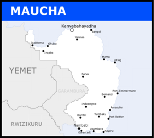
Maucha, officially the Democratic Republic of Maucha, is a sovereign state whose territory is in northeastern Couis. Maucha is the easternmost country in the western hemisphere, occupying a total area of 419,033 km² on the eastern coast of the subcontinent of Bahia. It borders Yemet and Garambura to the west. Maucha has territorial disputes over the Ibabochia region with Yemet and the Kulo State. Maucha is the third most populated country in Bahia with a population of 30,955,202 (as of January 2020). The capital of the country is Kanyabahayadha, located at the delta of the Fedha river on the northern coast of the country. The metropolitan region of Nambabi is the largest urban area of the country and often claimed to be the legitimate Mauchian capital.
EARLY HISTORY
After the breakaway from the United Bahian Republic, Maucha fell into a civil crisis, as minorities started to revolt against the ethnic government. The main insurgence happened in the Onikhuma provinces, as they claimed that the Government favored the Watuaji and gave them no representation. In 1967, a civil war started after Watuaji President, Asani Ibori, dissolved the National Congress, trying to shut any and all uprisings against his government. Ibori’s authoritarian government and the Civil War would last until 1978, when the Onikhuma movement, supported by other minorities, overthrew Ibori’s seat. The new republic was established in 1978 and sought to open Maucha to foreign investment and private capital, but in 1980, a coup saw a communist militia group taking over the government and creating a one-party system. In 1993, the Maucha Revolution took place, as the people fought against the corrupt and authoritarian government. Later in the same year, the Democratic Republic of Maucha was established, now under a new multi-party system that focused on democracy. The first public election in the country took place in 1995, with Onikhuma President Dominic Iondela being the first democratically elected president in Maucha’s history. From then on, Maucha is considered one of the fastest growing countries in Bahia
GENERAL ECONOMIC/SOCIAL INFO
Etymology
History
Antiquity
Modern Kingdoms
The fall of the Chisomo Dynasty of the Kingdom of Sena in 1653 marked the establishment of the Njinji-Susulu Confederacy and its hegemony in the territories south of the Iwoye River. The Confederacy succeeded in expanding their territory north of modern-day Maucha but found resistance from the Onikhuma Kingdom, another well-settled local kingdom. From the beginning of the 18th century up to 1786, both the Onikhuma Kingdom and Njinji-Sisulu Confederacy fought a series of battles in what became known as the XXXX War. Ultimately, the Onikhuma Kingdom was subjugated by Mabuti I and became a part of the Confederacy. Despite the growing conflicts down in the Gonda Delta against the Gaullicans, the Confederacy kept on pushing their forces up to the Watuajuan coast.
By the end of the 18th century, the Watuajuan Confederation had become an extremely well-organized and well-developed State, with many international merchants arriving for their abundant silver. The Watuajuan Confederation dominated the delta of the Fedha River and extended its area to the northernmost part of modern-day’s Maucha’s panhandle. Such wealth and stability attracted Weranian missions, who looked forward to commercializing silver with the Watuajuan. In 1809, the Battle of Yalansa put the Njinji-Sisulu Confederacy on the edge after an easy victory from the Watuajuan forces. After a few years of backing off, the Njinji-Sisulu came back for a new attempt, this time succeeding and taking over the cities of Yalansa in 1829, and Bangoli in 1832, and exposing the Watuajuan capital city of Kanyabahayadha to the invaders. Noticing the clear disadvantage, the Watuajuan signed the Military Contract of 1835, which allowed the Weranian military to have jurisdiction over the Watuajuan land. This allowed Weranians to assist in the Watuajuan resistance against the Njinji-Sisulu and push back the invasion by reconquesting Bangoli in 1838 and Yalansa in 1840.
The Watuajuan Confederation kept on pushing the Njinji-Sisulu Confederacy back south, as they slowly took over their territory. By 1861, all former Kingdoms under the Njini-Sisulu north of the Iwoye River were freed and admitted into the Watuajuan Confederacy. In 1865, Nambabi was surrounded and sieged. The Sisulu Capital finally succumbed in 1869. The Watuajuan Confederacy, then renamed the Mwisho Empire, remained independent until 1876 when it became an official colony of Werania.
Geography
Climate
Biodiversity
Demographics
Largest cities in Maucha
2020 Census | |||||||||
|---|---|---|---|---|---|---|---|---|---|
| Rank | Maucha | Pop. | |||||||
 Nambabi  Garastadt |
1 | Nambabi | Nambabi C.S. | 2,514,214 |  Kanyabahayadha  Usambara | ||||
| 2 | Garastadt | Garastadt C.S. | 1,805,664 | ||||||
| 3 | Kanyabahayadha | Kanyabahayadha C.S. | 1,156,782 | ||||||
| 4 | Usambara | Hëna | 710,746 | ||||||
| 5 | Bomtili | Valqëndrush | 678,152 | ||||||
| 6 | Bangoli | Kallëm | 517,013 | ||||||
| 7 | Indwengwe | Corchès | 489,357 | ||||||
| 8 | Ibabitema | Sèngsagrát | 477,781 | ||||||
| 9 | Port Zimmermann | Fillim | 432,776 | ||||||
| 10 | Amasufer | Dxèrdxè | 343,979 | ||||||
Ethnicities
Religion
Languages
Education
Government & Politics
Foreign relations
Military
Administrative Divisions
|


