Serramana: Difference between revisions
Jump to navigation
Jump to search
No edit summary |
No edit summary |
||
| Line 18: | Line 18: | ||
|image_map = SerramanaMontage.png | |image_map = SerramanaMontage.png | ||
|alt_map = <!--alt text for map--> | |alt_map = <!--alt text for map--> | ||
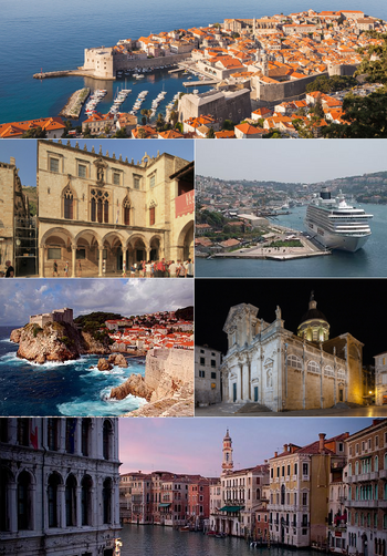
|map_caption = Photographic Montage of | |map_caption = Photographic Montage of Serramana city. | ||
|image_map2 = Djerba topographic map-fr.svg | |image_map2 = Djerba topographic map-fr.svg | ||
|alt_map2 = | |alt_map2 = | ||
| Line 41: | Line 41: | ||
|government_type = {{wp|Unitary}} {{wp|parliamentary}} {{wp|diarchic}} {{wp|Directorial system|directorial republic}} | |government_type = {{wp|Unitary}} {{wp|parliamentary}} {{wp|diarchic}} {{wp|Directorial system|directorial republic}} | ||
|leader_title1 = {{wp|Consul|Consuls-Regent}} | |leader_title1 = {{wp|Consul|Consuls-Regent}} | ||
|leader_name1 | |leader_name1 = ??? <br> ??? | ||
|legislature = {{wp|Congress|Grand and General Council}} | |legislature = {{wp|Congress|Grand and General Council}} | ||
|upper_house = <!--Name of governing body's upper house, if given (e.g. "Senate")--> | |upper_house = <!--Name of governing body's upper house, if given (e.g. "Senate")--> | ||
| Line 61: | Line 51: | ||
|established_event2 = ??? | |established_event2 = ??? | ||
|established_date2 = ??? | |established_date2 = ??? | ||
|established_event3 = | |established_event3 = Rose Revolution | ||
|established_date3 = | |established_date3 = February 22, 1911 | ||
|established_event4 = | |established_event4 = | ||
|established_event4 = | |established_event4 = | ||
|area_rank = | |area_rank = | ||
|area_magnitude = | |area_magnitude = | ||
|area = | |area = | ||
|area_km2 = | |area_km2 = 72 | ||
|area_sq_mi = 198 | |area_sq_mi = 198 | ||
|area_footnote = <!--Optional footnote for area--> | |area_footnote = <!--Optional footnote for area--> | ||
| Line 75: | Line 65: | ||
|area_label2 = <!--Label below area_label (optional)--> | |area_label2 = <!--Label below area_label (optional)--> | ||
|area_data2 = <!--Text after area_label2 (optional)--> | |area_data2 = <!--Text after area_label2 (optional)--> | ||
|population_estimate = | |population_estimate = 32,000 | ||
|population_estimate_rank = | |population_estimate_rank = | ||
|population_estimate_year = | |population_estimate_year = 2018 | ||
|population_census = | |population_census = 31,872 | ||
|population_census_year = | |population_census_year = 2015 | ||
|population_density_km2 = | |population_density_km2 = 442 | ||
|population_density_sq_mi = | |population_density_sq_mi = | ||
|population_density_rank = | |population_density_rank = | ||
Revision as of 11:54, 25 March 2019
The Free State and Republic of Serramana Istadu Liberu e Repùblica Serramana | |
|---|---|
| Motto: Cando si tenet su bentu est prezisu bentulare! When the wind is in your harbour, Is the proper time to winnow | |
| Anthem: ??? "???" | |
 Photographic Montage of Serramana city. | |
Topographical map of Serramana. | |
| Capital | Serramana (city-state) |
| Largest Bighinadu | Sarroccu |
| Official languages | Serramanese Latin |
| Ethnic groups | 72% Serramanese 13% ??? 15% Others |
| Demonym(s) | Serramanese |
| Government | Unitary parliamentary diarchic directorial republic |
| ??? ??? | |
| Legislature | Grand and General Council |
| Independence | |
• ??? | ??? |
• ??? | ??? |
• Rose Revolution | February 22, 1911 |
| Area | |
• | 72 km2 (28 sq mi) |
| Population | |
• 2018 estimate | 32,000 |
• 2015 census | 31,872 |
• Density | 442/km2 (1,144.8/sq mi) |
| GDP (nominal) | 2017 estimate |
• Total | $13.2 billion |
• Per capita | $15,648 |
| Gini (2014) | 23.2 low |
| HDI (2017) | 0.852 very high |
| Currency | Serramanese Lira (SRL) |
| Date format | dd.mm.yyyy |
| Driving side | right |
| Calling code | +420 |
| ISO 3166 code | SRM |
| Internet TLD | .co.sm |

