User:Bigmoney/Sandbox15: Difference between revisions
Jump to navigation
Jump to search
| Line 132: | Line 132: | ||
|footnotes = <!--For any generic non-numbered footnotes--> | |footnotes = <!--For any generic non-numbered footnotes--> | ||
}} | }} | ||
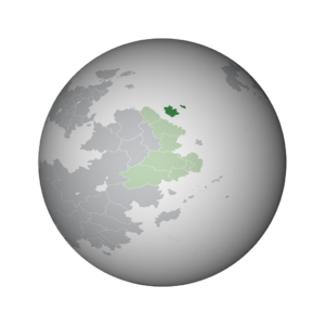
'''Kitaubani''', known officially as the '''Kingdom of Kitaubani''', is a sovereign state located off the coast of [[Bahia]]. | '''Kitaubani''', known officially as the '''Kingdom of Kitaubani''', is a sovereign state located off the coast of [[Bahia]]. An island nation, it shares a maritime border with [[Asase Lewa]] and [[Sabaw]] to the southeast. | ||
Revision as of 02:50, 14 August 2023
Kitaubani
Kingdom of Kitaubani Masarautar Kitaubani (Hausa) | |
|---|---|
|
Flag | |
| Motto: Umoja katika Utofauti Unity in Diversity | |
| Anthem: "Local name" "O, Kitaubani" | |
 Kitaubani (dark green) within the Congress of Bahian States (light green) in Bahia | |
| Location | Bahia |
| Capital | Kwamuimepe |
| Largest | Gashi |
| Official languages | Hausa, Watuajua |
| Ethnic groups (2023) | |
| Religion (2023) | List
|
| Demonym(s) | Kitauban |
| Government | Unitary constitutional monarchy |
• Queen | Medare I |
• Premier | Balarabe Zango |
| Independence from Werania | |
| Area | |
• | 259,786.24 km2 (100,304.03 sq mi) |
| Population | |
• 2023 estimate | 21,974,231 |
| GDP (PPP) | 2023 estimate |
• Total | $371,210,684,283 |
• Per capita | $16,893 |
| GDP (nominal) | 2023 estimate |
• Total | $143,667,522,278 |
• Per capita | $6,538 |
| Currency | Kitauban Wuri (₩) (KBW) |
| Time zone | UTC+3 (BST) (Lorem ipsum: +4) |
| Driving side | right |
| Calling code | +27 |
| Internet TLD | .kb |
Kitaubani, known officially as the Kingdom of Kitaubani, is a sovereign state located off the coast of Bahia. An island nation, it shares a maritime border with Asase Lewa and Sabaw to the southeast.
