Freedonia
Kingdom of Freedonia Kingdom of Freedonia | |
|---|---|
|
Flag | |
 | |
| Capital and largest city | Oxcourt |
| Official languages | English |
| Recognised national languages | English |
| Ethnic groups (2021) |
|
| Religion (2021) |
|
| Government | Unitary Regional Parliamentary Constitutional Monarchy |
• Monarch | King Christopher Woolworth |
• Prime Minster | Caroline April |
| Establishment | |
• First Human Settlement/ Discovery | 1066 |
• Formation of the Kingdom of Freedonia | April 18, 1707 |
• First Democratic Elections | February 1, 1910 |
| Area | |
• | 78,550 sq mi (203,400 km2) |
| Population | |
• 2022 census | 11,320,000 |
• Density | 144.11/sq mi (55.6/km2) |
| GDP (PPP) | 2021 estimate |
• Total | $339,600,000,000 |
• Per capita | $32,000 |
| GDP (nominal) | 2021 estimate |
• Total | $283,000,000,000 |
• Per capita | $25,000 |
| Gini (2021) | 26.8 low |
| HDI (2021) | 0.935 very high |
| Currency | Freedonia Pound (F£) |
| Time zone | Freedonia Time |
• Summer (DST) | Freedonia Summer Time |
| Date format | mm-dd-yyyy |
| Driving side | left |
| Calling code | +22 |
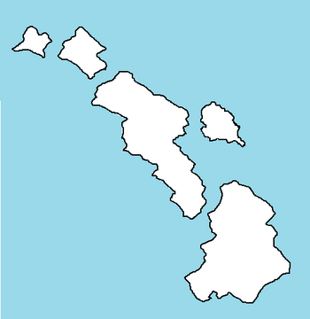
The Kingdom of Freedonia or just Freedonia is a nation in the Coalition of Crown Albatross located of the coast of the continent of Adula, in the Toyana Ocean. The Kingdom is divided into 5 Regions. Freedonia is a developed country.
Etymology
The first theory comes from Freedom lands or Free lands. Another theory comes from a ancient settlement that may or may not existed before the widely accepted date of humans first arriving on the Freedonia Islands in 1066. It is unclear when the inhabitants of the islands starting calling their lands Freedonia.
History
Geography
WIP
Climate
The climate of Freedonia is humid subtropical. With a peak in rainfall during the summer months. Rainfall for the most part is evenly distributed throughout the year. Temperatures during the summer can range from 80°F to 86°F along the coastal plains and hills. In the highlands temperatures range from 72°F to 78°F.
During the winter temperatures range from 63°F to 68°F. In the highlands temperatures range from 55°F to 60°F. Snow is rare along the coasts and hills. Only the highest elevations receive regular snowfall. Precipitation ranges from 50 to 55 inches along the coast. To 65 inches to 80 inches in the highlands.
Hurricanes are common during the summer months. However, the strength of the hurricanes are usually weak. Tornadoes are rare, but can occur especially during the summer. Heatwaves are defined at temperatures above 90°F for 3 days or more. Heatwaves are common and can occur during the Spring, Summer, and Fall. Coldwaves or Cold snaps can occur during the late Fall, Winter, and Early Spring. Temperatures can reach 35°F or colder during the night time.
The hottest temperature ever recorded was 106°F in January of 1973. The coldest temperature ever recorded was 6°F in the mountains in July of 1977.
Biodiversity
Demographics
Religion
Language
Administrative Division
Freedonia is broken up into 5 Regions. Each region is subdivided into Counties. Each County is divided into two categories. Unincorporated land and Incorporated Municipalities.
A Region is a sub-national political entity that has some governmental authority as enshrined in the Constitution of Freedonia. A Region has a Premier that is elected by the Regional unicameral legislature assembly or Parliament. Each Region is divided into counties. Each County has a Chief Administrator elected by the local population. Each County is divided into unincorporated land which is controlled by the county government and incorporated land which is controlled by the Municipality.
Cities
| Rank | City Name | City Population |
|---|---|---|
| 1 | Oxcourt | 329,000 |
| 2 | Golden Beach | 294,000 |
| 3 | Hartridge | 253,000 |
| 4 | Regina Beach | 192,000 |
| 5 | Port York | 178,000 |
| 6 | Coalwood | 164,000 |
| 7 | Jamestown | 151,000 |
| 8 | Saint Jarvis | 129,000 |
| 9 | Saint George | 122,000 |
| 10 | Betty's Bay | 108,000 |
