Torúmalana
| Torúmalana | |
|---|---|
 | |
| Highest point | |
| Elevation | 5,711 m (18,737 ft) |
| Listing | Country high point Provincial top Ultra Haele-Rismikhar |
| Naming | |
| Translation | Mountain of thunder (Ahéri) |
| Pronunciation | /toʊˈrumɑːlɑːnɑː/ |
| Geography | |
| Parent range | (Vekra Retiqa cordillera) |
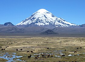
Torúmalana (Ahéri pronunciation: /toʊˈrumɑːlɑːnɑː/) is a mountain in the , a range of the Vekra Retiqa cordillera, in Hysera's Zha'tar province. It is the highest point in Teudallum, the highest point in Western Astyria and the highest volcano in Astyria. Its peak reaches a height of 5,711 metres (18,737 ft).
It sits pretty far away from other mountains in southeast Zha'tar but the area around it is tundra so maybe it's on a plateau or something
Geology
Torúmalana is a volcanic summit, initially formed by the convergent interaction of the Arithemlan plate (now part of the Mederano plate) with the Jajexan and Parthenopean plates. The resulting subduction zone, as the Jajexan plate sank under the Arithemlan plate, created rising magma plumes within the mantle that formed numerous volcanos across northern Trellin. Torúmalana is a stratovolcano that may be dormant or extinct. It is not thought to have erupted in the past ten thousand years, although its name means 'mountain of thunder' and may preserve an ancient tradition of eruptivity.