User:Latium/Sandbox3
Kingdom of Aretias | |
|---|---|
| Motto: Զիջել ոչ մեկին Zijel voch’ mekin ("Yield to none") | |
| Anthem: Վարդի մարտ Vardi mart March of the Rose | |
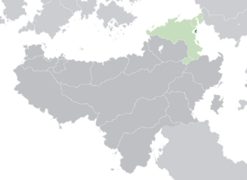
 Location of Aretias (dark green) – in Belisaria (dark grey) | |
| Political Map of Aretias Political Map of Aretias | |
| Capital and largest city | Evros |
| Official languages | |
| Recognised regional languages | Latin |
| Ethnic groups (2019) |
|
| Religion | State religion: Vardanan Apostolic Other recognized: Eastern Orthodoxy, Fabrian Catholicism, Azdarin, Alban Emendatic, Judaism, Irreligion |
| Demonym(s) | Aretian |
| Government | Unitary absolute monarchy |
• Basileus | Basil III |
| Andreas Kiurikian | |
| Legislature | Council of State |
| Independence from the Second Vardanan Republic | |
• Declaration | 19 July 1924 |
| Area | |
• | 3,616 km2 (1,396 sq mi) (nth) |
| Population | |
• 2020 estimate | 965,577 |
• 2013 census | 850,996 |
• Density | 235.34/km2 (609.5/sq mi) |
| GDP (PPP) | 2020 estimate |
• Total | $X billion |
• Per capita | $X |
| GDP (nominal) | 2020 estimate |
• Total | $X billion |
• Per capita | $X |
| HDI | 0.873 very high |
| Currency | Dram (Դ) (ARD) |
| Date format | dd/mm/yyyy (AD) |
| Driving side | left |
| Calling code | +577 |
| ISO 3166 code | AE |
| Internet TLD | .ae |
Aretias, officially the Kingdom of Aretias (Vardanan: Թագավորության Արետիաս; Mysian: Βασίλειον τῆς Ἀρητιάς), is a semi-recognized sovereign state located off the western coast of the Chersonian Peninsula. It is located on an archipelago in the Periclean Sea, and shares maritime borders with Thraysia to the north, Vardana to the east, and Perateia to the southwest. Its capital, and largest city, is Evros.
The first human settlements in Aretias date back to the 11th century BCE, with the first Aradian and Lihnidosi Hellene colonies established in the 8th and 9th centuries BCE. Aretias has long been a territory of successive empires and kingdoms since the 6th century BCE. Until 1832, Aretias was a province of the Kingdom of Vardana, and from 1832 until 1901 a province of the Kingdom of Mysia. The islands remained under control of the House of Bznuni after re-integration into Hazaraspid Vardana. During the 1924 Revolution, the Lord of Aretias maintained control of the islands and attempted to re-establish control of the mainland until his death in 1933. Since 1924, Aretias has laid claim to Vardana and Mysia by way of both royal titles.
Aretias is a unitary absolute monarchy, with a limited unicameral legislature. Its population is near evenly split between a plurality of Mysians and Vardanans, along with other minority groups. Aretians are overwhelmingly christian, primarily following the Vardanan Apostolic faith, which is the official state religion.
Etymology
Aretias is a minor archipelago surrounding the main island from which the country takes its name. The territory consisting of modern Aretias has held numerous names since the first recorded human settlements. Aretias was first used as a name for the main island in the 2nd century BCE, coming from the Hellenic meaning "Island of Ares". During the period of Latin control, from the 2nd to 5th centuries CE, the islands were referred to as Aretium in imperial documents, roughly meaning "Island of Mars", however Aretias remained the most widely used name.
History
Prehistoric and ancient history
Middle ages
Early modern history
Independence and modern history
Geography
Aretias has an area of 3,616 square kilometers, which consists of the main island, also named Aretias, and a series of smaller islands surrounding it. The main island has an area of X, equating nearly X% of the nation's territory. The country is X kilometers off the coast of the Vardanan province of Mysia, X kilometers from the Diocese of the East, and X kilometers from the coast of Thraysia.
The main island is dominated by a small mountain range, the Agrafa Mountains, and a central-to-coastal plain crossing the island. The Agrafa Mountains cover most of the northern end of the island, and together with southern hills surround the central plain. The Evros River runs through the center of the country, and is the longest river in Aretias. Mount Baghats, as part of the Agrafa Mountains, is the highest point in Aretias at 2,109 meters.
Climate
Aretias has a typical Periclean climate, with semi-arid tendencies inland at mid-level elevations of mountains. Coastal winters are mild, with hot summers. Coastal communities experience some of the hottest days in the Periclean during the summer, reaching upwards of 80 °F during the day, on average, during the peak of summer.
Winters remain warm in Aretias. The average winter temperature in the capital of Evros sees a daily average of 66°F, with nightly lows near 45°F. Snow is possible at the highest peaks of the Agrafa Mountains, particularly Mount Baghats.

