Envadra Region
Envadra | |
|---|---|
 | |
| Country | Gylias |
| Capital | Mayt |
| Area | |
| • Total | 113,781 km2 (43,931 sq mi) |
| Population (2020) | |
| • Total | 962,752 |
| • Density | 8.5/km2 (22/sq mi) |
| Demonym | Envadran |
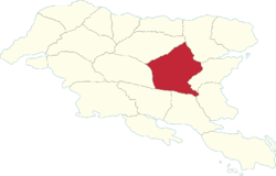
Envadra (abbreviated EN) is a region of Gylias. Located in central Gylias, it borders Mişeyáke and Arxaþ to the north, Nezyál to the east, Ḑarna, Aðuna, and Herlan to the south, and Arsad to the west.
Geography
The Kackar mountains traverse the region's territory from north to south, separating the Laişyn plain in the east and the Niavelin plain in the west.
The Nazar river determines its boundaries with Arxaþ, Nezyál, Herlan, and Aðuna.
Demographics
The 2020 census recorded a population of 962.752. Large cities include Mayt, Nazrin, and Şenri.
The main Gylic peoples in the area are Aréş, Zineran, Varan, and Aðunese.
Economy
The region's economy is primarily based on industry and the service sector, with agriculture playing a comparatively reduced role.
Mountaineering and winter sports are the primary drivers of tourism.
Politics
The region's regional council is named the Envadra Regional Council, and its regional party is named the Envadra League (French: Ligue pour Envadra).
Envadra's politics have largely been defined by the east–west split engendered by the Kackar mountains. Eastern Envadra is strongly left-wing, owing to the influence of neighbouring Mişeyáke, while western Envadra is more eclectic, reuniting non-inscrit leftists, liberals, and conservatives in the south.