Cordomonivence
This article is incomplete because it is pending further input from participants, or it is a work-in-progress by one author. Please comment on this article's talk page to share your input, comments and questions. Note: To contribute to this article, you may need to seek help from the author(s) of this page. |
Democratic states of Cordomonivence Demokratischei Staaten von cordszchvon | |
|---|---|
File:Cordomonivence flag.png cordomonivence flag Flag | |
| Motto: Särtke duerch freicheit (Strength through freedom) | |
| Anthem: für volki und land (For the people and the country) | |
 | |
| Capital | Cordobenza |
| Largest city | Mushnetman |
| Official languages | Cordobez (germanic language) |
| Demonym(s) | Cordobez |
| Government | Federal presidential constitutional republic |
• | Mattis Kaspar Heinrichs (president) |
• | Agustin Linus Wang (vice president) |
| Legislature | Supreme Congress of the Democratic States of Cordomonivence |
| Area | |
• Total | 534,271 km2 (206,283 sq mi) |
• Water (%) | 5.45 |
| Population | |
• june 2023 estimate | 54,653,840 |
• 2021 census | 54,083,729 |
• Density | 142/km2 (367.8/sq mi) |
| GDP (PPP) | 2022 estimate |
• Total | 2,222,460,232,480 (2.2 trillion) ACU |
• Per capita | 40,732 ACU |
| GDP (nominal) | 2022 estimate |
• Total | 1,933,805,566,600 (1.9 trillion) ACU |
• Per capita | 35,365 ACU |
| Gini (2022) | low |
| HDI (2022) | high |
| Currency | Cordobez guilder C̳ (a C̳ is worth 0.74 ACU) |
| Time zone | UTC-1 |
| Driving side | right |
| Calling code | +75 |
| Internet TLD | .cor |
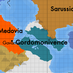
Cordomonivence Officially known as The democratic states of Cordomonivence is a sovereign democratic state located in southern Thrismari Cordomonivence is a federal presidential constitutional republic that is divided into 48 autonomous federal states, each with its different degree of autonomy. The population of Cordomonivence is estimated at 54,083,729 million. Its capital and second largest city is cordbenza which is located in the South of Cordomonivence in the state of cozrodbeniz. Cordomonivence has a total size of 534,271 thousand square kilometers. Cordomonivence claims the entire Taubon Strait and about 7 nautical miles of it as territorial waters.
Cordomonivence limits terrestrially with 3 countries,Medovia,Sautida and Sarussia being the border with Sarussia the most extensive border that Cordomonivence has.Cordomonivence has access to the Taubon Strait, the Marmor sea and the Kaldaz ocean.
Etymology
The denomination of "Cordomonivence" from the evolution of the term "Cordkszvoschonn elandenn" which was an old way of referring to the lands of the current cordomonivence except for the current state of Kreinsmät, to the southeast. It is known that this term has been used, al less, since the 200s although this term was more used during the "unification era". This term has evolved to the current term, "Cordoshkvönn" or Cordomonivence in common language
History
WIP
Government and Politics
WIP
Geography
WIP
Culture
WIP
Demographics
WIP
Economy
WIP
Infrastructure
WIP
Cities
WIP