Lurona
Republic of Lurona Repubblica di Lurona Luronako Errepublika | |
|---|---|
|
Flag | |
| Motto: TBD | |
| Anthem: | |
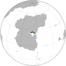
 Location of Lurona in Stratea | |
| Location | Gulf of Atily region of Stratea |
| Capital and largest city | Bellanera |
| Official languages | Caputian, not!basque |
| Recognised regional languages | not!georgian, not!dargwa |
| Ethnic groups | By race:
|
| Religion |
|
| Demonym(s) | Luronan |
| Government | Federal Semi-Presidential Parliamentary Republic |
• Prime Minister | Dacio Annunziato |
• President | Costanzo Capello |
| Legislature | Parliament |
| Establishment | |
• TBDEVENT1 | TBDDATE1 |
• TBDEVENT2 | TBDDATE2 |
• TBDEVENT3 | TBDDATE3 |
| Area | |
• | 219,349 km2 (84,691 sq mi) |
| Population | |
• 2022 estimate | |
• 2020 census | 15,211,800 |
• Density | 70.24/km2 (181.9/sq mi) |
| GDP (PPP) | estimate |
• Total | ₭319.45 billion |
• Per capita | ₭21,000 (TBD) |
| HDI (2018) | very high |
| Currency | Luronan Lira (LUR) |
| Time zone | +TBD |
| Date format | dd-mm-yyyy |
| Driving side | right |
| Calling code | TBD |
| ISO 3166 code | LR |
| Internet TLD | .mn |
Lurona, officially the Republic of Lurona (Caputian: Repubblica di Lurona, not!Basque: Luronako Errepublika), is a country located in the Gulf of Atily region of Stratea. Covering an area of 216,578 km2 (83,621 sq mi), Lurona shares a border with Senarwa to the west, Vadurzil to the northwest, Aghankir to the north, Luxchqiri to the northeast, Mantocia to the east, and the Gulf of Atily to the south. With a population of 15.2 million, a slim majority of which are ethnic Caputian, Lurona is considered a crossroads between the Benevianism-dominated culture of northern Stratea and the majority-Bhai culture of southern Stratea, though nearly three-fourths of the population practices Benevianism. The Roclontane Mountains lie at the northern border of the nation.
Several ancient indigenous groups called the Gulf of Atily region their homes, many concentrated in the coastal savannahs of modern-day Mantocia but some calling the harsh deserts surrounding the inner Gulf of Atily their home. One of these groups were the Vigars (related to the modern-day Caputians and Ovist Caputians of Lurona) who inhabited the northern shoreline of the Gulf continuously since the 2nd century BCE. Another were the Nahasque, a group of desert nomads. Subjugated by the Mavonan Empire in 103 BCE, these groups' territories were integrated into the Mavonan province of Atilia. In 213, the Mavonans founded the city of Bellanera, which would later become the Luronan capital. During the split of the Mavonan Empire after the death of EMPERORTBD in 402, the province of Atilia fell under the rule of Upper Mavona. However, the Emperor of Upper Mavona based in TBDCITY was able to exert little influence over the region after the collapse of Middle Mavona in 483, and the lands to the west of the Mantocian coast were once again ruled by the Vigars. The Vigars annexed the last Mavonan holdovers in Atilia by 600, sacking the city of Rosella in present Mantocia and then establishing it as their base of operations. Starting in the 8th century, the Vigars led raids reaching as far as Pätschlàn, bringing wealth to the otherwise desolate Gulf of Atily. The Vigar king Mantocio the Swordborn centralized his territories into the Mantocian Kingdom in 1094 and converted to Benevianism.
However, after the death of Mantocio in 1103, his kingdom was swiftly invaded by the Bhaist Cagarian Dalamate, who had conquered the vast majority of the southern coast of the Gulf of Atily. Cagarian rule would last until 1157, when Vigar remnants under TBDDESCENDANTKING successfully laid siege to Bellanera.
