Bugan (state)
Bugan
Bugan Bucharyod (Kjerso) | |
|---|---|
State | |
| Nickname(s): «Gold Bucharyod» (Great State) | |
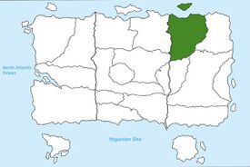
Location of Bugan in Yogania. | |
| Country | Yogania |
| Region | Kjerso |
| Capital city | Bugan (city) |
| Established | 1799 |
| Government | |
| • Type | State government |
| • Governor | Jakob Yolnaryd |
| • Assistant Governor | Jom Aldrin Gorkler |
| • Capital city mayor | Jom Bulagen |
| Area | |
| • State | 444,745 km2 (171,717 sq mi) |
| • Land | 403,931 km2 (155,959 sq mi) |
| • Water | 40,814 km2 (15,758 sq mi) |
| • Urban | 92,308 km2 (35,640 sq mi) |
| • Rural | 313,747 km2 (121,138 sq mi) |
| Population (2022) | |
| • State | 39,526,897 |
| • Density | 89/km2 (230/sq mi) |
| Demonym | Buganol |
| Time zone | UTC +3, +4 |
| Area codes | 90-99 |
| Website | www.yogorydgovernar.yo |
Bugan is one of the 22 states of Yogania. It is located at the very north of the region of Kjerso, in eastern Yogania. The capital is the homonymous city of Bugan, which is also the largest city in the state with over 20 million inhabitants. Bugan is home to the Buganol lake and the Buganollien mountains in the northeast, which are some of the most visited landmarks in Yogania with 12 million visitors in 2018 according to the YSI. The Byroder Plain Metropolitan Area in the south of the state is one of the most populated urban areas in Yogania, regrouping 4 major cities for a population of over 36 million inhabitants. Bugan has historically been an important area for Kjerso, the city of Bugan having been the kingdom's capital from 441 A.D. to 1227.
Etymology
Bugan gets it´s name from the capital city Bugan. It was named after the Buganollien mountain chain, the word Buganollien is an Ancient Kjerso word describing lakeside mountains.
Geography and Climate
Physical Geography
Bugan's territory is dominated by the Byroder plain spanning through most of the area. The Buganollien mountain chain, shared with the neighboring state of Gordevol, covers most of the eastern part of the state and continue in the north, while the uninhabitable Jogal plain and Goldsend hills cover the remaining northern part of Bugan. The main source of water is the Buganol lake located near the Buganollien mountains, from which flows the Buganheulen river, one of the longest rivers in Yogania.
Administrative Geography
Bugan is located north of the region of Kjerso, in the east of Yogania. It is one of the northernmost states of Yogania. It borders the North Atlantic Ocean in the north, the states of Buryako and Budlin in the south, the state of Gordevol at the east, and the state of Buryatia at the west.
Climate
The northern part of Bugan is home to an ice-cap climate (eternal winter) with average temperatures never exceeding 0 degrees Celsius. It is completely uninhabited. The rest of the state has a cold subarctic climate with average temperatures in the coldest months going below -38 degrees Celsius and rarely exceeding 18 degrees Celsius in summer. The city of Bugan is known for being the coldest large city in the world.
Demographics
Population
Bugan is the 8th most populated Yoganian state with a total population of 39,526,897 inhabitants as of 2022 (YSI). Most of the population is concentrated in the Byroder Plain area, where the largest cities are located. The northern part of the country is uninhabited because of extreme climate.
