Horseshoe Bay (body of water)
Jump to navigation
Jump to search
| Horseshoe Bay | |
|---|---|
 Horseshoe Bay | |
| Type | Bay |
| Ocean/sea sources | Olympic Ocean, Kasuum Sea, Tarin Sea |
| Basin countries | Zamastan, Gladysynthia |
| Surface area | 689,500 km2 (266,200 sq mi) |
| Average depth | 600 m (2,000 ft) |
| Max. depth | 3,203 m (10,509 ft) |
| Settlements | Tofino, Danaska, Horseshoe Bay, Providence, Kelowna, Jade Harbor, White Rock, Lower Tariel, Alberni |
For the city of the same name, see: Horseshoe Bay
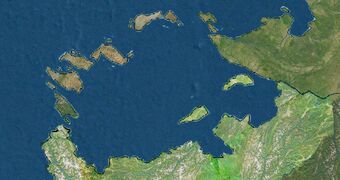
Horseshoe Bay is a large bay adjacent to the Tarin Sea and Kasuum Sea, largely surrounded by the extension northern islands of Zamastan. Although not geographically apparent, it is an ocean basin and a marginal sea of the Olympic Ocean. It is bounded by the continent of Euronia and the nations of Zamastan and Gladysynthia.
Etymology
The bay is named for Percilion Horseshoe, a Quetanan explorer who came across the body of water during his 1509 voyage to Euronia. Horseshoe Bay encompasses 689,500 km2 (266,200 sq mi), making it the second-largest water body using the term "bay" in the world (after Titania Bay, but often tied alongside Lerbin Bay, Elkjop Bay, and Siena Bay.)

