Matō
Matō | |
|---|---|
 | |
| Country | Akashi |
| Capital | Suzu |
| Area | |
| • Total | 40,344 km2 (15,577 sq mi) |
| Population (2020) | |
| • Total | 3,563,376 |
| • Density | 88/km2 (230/sq mi) |
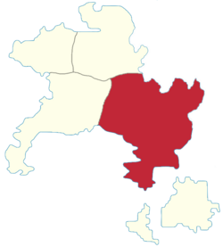
Matō (Miranian: 麻豆; Gothic: 𐌼𐌰𐍄𐍉; abbreviated MA) is a province of Akashi. Located in the east, it borders Kagi to the west and Kobi to the north, with Shimachi located to the south.
With a total area of 40.344 km2, it is Akashi's largest province.
Geography
The province's territory is dominated by the Tōhō Sanmyaku in the north, interrupted by a small plateau towards the eastern border, where Enri is located.
Usagiyama (兎山; "Rabbit Mountain"), Akashi's tallest peak, is located here. The mountain is named after its spectacular views of the moon, via reference to the moon rabbit legend.
The Kōgen hills extend from the mountains to the coast, separating the western and eastern plains.
The largest rivers are Tsukikawa and Akagawa in the east (with Eikō located at their confluence).
Demographics
The 2020 census recorded a population of 3.563.376, making it Akashi's most populated province. The largest cities are:
- Hirakawa — the national capital.
- Suzu — the regional capital.
- Yokoyama — located near Usagiyama, a major tourist destination.
- Eikō
- Enri — Akashi's easternmost large city.
Economy
Matō's economy is dominated by industry, services, and agriculture.
Yokoyama's economy is mainly based on tourism, while Hirakawa has a strong services sector and Suzu is one of Akashi's largest ports.
Politics
Matō is a closely contested province between leftists and progressive conservatives.