Mekabiri: Difference between revisions
m (→History: +notebook ideas) |
m (→Ethnic groups: +notebook ideas) |
||
| Line 318: | Line 318: | ||
=== Ethnic groups === | === Ethnic groups === | ||
Mekabiri has a population of around 9 million people. The population is relatively young, with a median age of around 30 years. The country has a diverse mix of ethnicities. Most of the people have mixed ancestry in some degree. Everyone born in the country is treated as Mekabirian, independent of heritage. Racism is an {{wp|Bail|unbailable crime}}. <ref name='nswiki-emakera'/> One notable minority group in Mekabiri is the Orinese community, which has a long history in the country. [[Orioni]] occupied parts of Mekabiri for many centuries. Since intermarriage between the settlers and the natives was very usual, there are still significant numbers of people of Orinese descent living in Mekabiri, particularly in the south of the country. These communities are concentrated in cities such as [[#Geography|Piri]] and [[#Geography|Mi'irabi]], and they often speak [[Oharic language|Oharic]] as their second language. Many people of Orinese descent in Mekabiri are engaged in trade and commerce, and they have played a significant role in the economic development of the country. | Mekabiri has a population of around 9 million people. The population is relatively young, with a median age of around 30 years. The country has a diverse mix of ethnicities. Most of the people have mixed ancestry in some degree. Because of the country's mixed geography, the ethnic groups and provinces are also separated by geography. The northern highlands share a similar culture. The southern coastal areas are more focused on the sea. Border areas have a strong cultural mix. Everyone born in the country is treated as Mekabirian, independent of heritage. Racism is an {{wp|Bail|unbailable crime}}. <ref name='nswiki-emakera'/> One notable minority group in Mekabiri is the Orinese community, which has a long history in the country. [[Orioni]] occupied parts of Mekabiri for many centuries. Since intermarriage between the settlers and the natives was very usual, there are still significant numbers of people of Orinese descent living in Mekabiri, particularly in the south of the country. These communities are concentrated in cities such as [[#Geography|Piri]] and [[#Geography|Mi'irabi]], and they often speak [[Oharic language|Oharic]] as their second language. Many people of Orinese descent in Mekabiri are engaged in trade and commerce, and they have played a significant role in the economic development of the country. | ||
=== Religion === | === Religion === | ||
Latest revision as of 10:46, 10 April 2024
State of Mekabiri مکبیری (Ala) | |
|---|---|
Motto: Somnium vita est (Life is a dream) | |
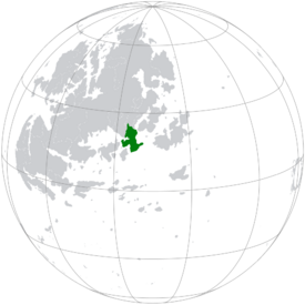 Location of Mekabiri | |
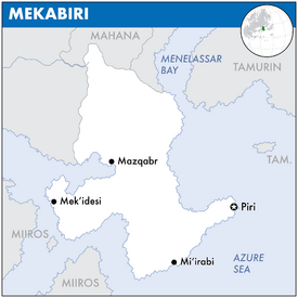 Map of Mekabiri | |
| Capital | Piri |
| Largest | Mi‘irabi |
| Recognised national languages |
|
| Recognised regional languages | |
| Ethnic groups |
|
| Religion | Juluvanism |
| Demonym(s) | Mekabirian |
| Government | Unitary presidential republic |
• President | Rahaēli Sērafīmi |
• Vice President | Richard Haller |
| Legislature | National Congress of Mekabiri |
| Càmara dos Senadores | |
| Càmara dos Deputados | |
| Independence from Orioni | |
• Independence | 1822 |
• Constitution | 1825 |
| Area | |
• | 522,586 km2 (201,772 sq mi) |
| Population | |
• 2022 estimate | 9,155,000 |
• 2020 census | 9,149,522 [a] |
| Currency | Mekabirian galoniye |
| Antipodes | Bexshaw, Eulycea |
| Driving side | right |
| Internet TLD | .me |
Mekabiri, officially the State of Mekabiri and internally known as Mek'abiri, is a sovereign state in Eastern Europa on Eurth. It is situated on the western shore of the Byzantine Sea and the northern shore of the Azure Sea. The country is bordered by Mahana to the north, Tamurin and Orioni in the east, and Miiros in the southwest. Piri is the capital and Mi‘irabi is the largest city; other major cities include Mazqabr and Mek’idesi. Mekabiri is approximately 522,586 km2 (201,772 sq mi) in size, without the territorial waters. The country is home to 9,149,522 inhabitants.
Mekabiri is a bicameral unitary presidential republic. The country's head of state is president Rahaēli Sērafīmi, supported by his Vice President Richard Haller. The territory that is now Mekabiri was first settled in prehistoric times. From the 14th century, it was a colony of Orioni until 1822 when the country gained its independence as a republic. Culturally, Mekabiri is still considered part of the Orinese diaspora.
The country's wealth comes largely from the industrial and tourism sectors, with limited contributions from fishing and services. International cooperation with Orioni represents a large share of the country's domestic product. Mekabiri is part of several international and intergovernmental institutions, including the Assembled Nations and Entente of Oriental States, as well as being a founding member of the Oriental Association for Regional Cooperation.
Etymology
The name of Mekabiri is an exonym, originating as the Oharic word Mek’abiri (መቃብር, “grave”). This name is a reference to the relative position of where the Sun sets or “goes to die” when viewed from Orioni. Other names have also been used, for example Mi'irabi (“west”), a term which applies to both Mekabiri and neighbouring Miiros. The frequent misspelling Merikebi (“ship” or “vessel”) is a reference to the many ships that once sailed back and forth between Mekabiri and Orioni. Late Aroman historical sources have come to associate Mekabiri's hot and unforgiving climate with the macabre, a place described as “having the quality of having a grim or ghastly atmosphere”.[citation needed]
During the colonial period (1349-1822) the country was called Birlini. Initially, the colonial expanse was limited to a coastal city where locals were mandated to accumulate resources at a storage facility named Perlinin. This infrastructure was designed to facilitate the transportation of these resources to Orioni. With time, the significance of Perlinin escalated, transforming from a mere warehouse to an urban settlement and eventually emerging as the capital of Mekabiri. Interestingly, while non-Orinese inhabitants commonly referred to the nation as Mekabiri, individuals from Orioni would employ the term Birlini. This nomenclature was a pars pro toto reference, highlighting the country's identification with its capital. Delving into the etymology of the word 'Perlinin', its roots can be traced back to Ancient Oharic, translating to “the house of the land of the lady”.[b]
In the coastal cities, the Oharic language is predominantly spoken and serves as the primary linguistic medium for millions. However, its prominence diminishes in the hinterland, where it functions more as a lingua aromana. Here, the indigenous Shakyan dialects dominate. Notably, to the Shakyan population, Mekabiri is colloquially known as “Dižgang”.
Geography
Mekabiri, situated in southeast Europa, boasts a strikingly varied geography, ranging from arid deserts and towering mountains to fertile plains and rich coastal regions. The absence of significant rivers is a distinct feature of Mekabiri's topography. However, along its southern coast, pockets of forests emerge, nurtured by the fertile soil, allowing the trees to attain impressive heights and robustness.[1]
The northern region of Mekabiri is designated as the Bidakiye highland, known in Mahanan as Upatyakā ("valley"). This elevated terrain provides a stunning contrast to the country's otherwise flat expanse. The $MountainName Mountains, positioned in the north, are amongst Mekabiri's most remarkable geographical elements. These mountains encompass some of the country's highest summits, including $PeakName, reaching an altitude of 4,567 m (14,984 ft). They are not only a favoured destination for mountain aficionados but are also dotted with Berber settlements. Emakera, a border province in Mekabiri, has historically felt the political and cultural influences of its neighbouring authoritarian state, Mantella. Mantellan tactics have included attempts to detach Emakera from Mekabiri by magnifying the differences between the northern and southern regions, capitalizing on and exacerbating cultural discrepancies.
Transitioning towards the central and western territories, the landscape takes on a more arid and desolate demeanour, with the vast expanse of the Amutian Desert stretching across this region. This desert, while stark, is punctuated with oases – verdant patches nourished by subterranean springs. Scattered throughout the desert are $NativeName communities, which have, over generations, adapted to the stringent desert conditions.
The southern coastline, being the most habitable region of Mekabiri, stands in stark contrast to the desert's aridness. Rich in small forests, this area benefits from its fertile soil, promoting the growth of robust trees. Piri, the capital of Mekabiri, is strategically situated at the estuary of the Piriwadi River. Positioned slightly to the west, the city's location within the temperate zone ensures a sensible river placement. The confluence of river and sea has allowed the city to evolve with a natural harbour, rendering it a crucial maritime hub. Historical remnants of the ancient dock from the Pearl Road further accentuate its rich maritime heritage.
Mekabiri's climate is predominantly characterized by its aridity. While the southern coast enjoys a more temperate climate, conducive to habitation and agriculture, the majority of the country is enveloped in desert heat. Occasional rainfall in the south ensures the survival of the forests, but precipitation is sparse elsewhere. The Byzantine and Azure coastlines are diverse in their offerings. Sandy shores, interspersed with quaint fishing hamlets, define the Byzantine coast. In contrast, the Azure coast houses bustling ports, notably Piri and Mi'irabi.
History
Pre-colonial period
- Early population came from Azania and Amutia in the west. The land used to be much greener, with more trees and grass. But after the last ice age ended, the climate became warmer and desertification increased.
- Prehistory: The changing climate led to more diversity in fauna and flora. And the early human cultures were also affected: fishermen along the coast, herders in the highlands, nomads in the desert.
- 1000-0 BCE: Small pockets of agriculture in some rare river valleys, mostly occupied with subsistence farming.
- 0-500s CE: The coastal area becomes tied into the Pearl Road. The peninsula is a crossroads for many other historic nations. Shakyan people begin their invasion and settle en masse in Mekabiri.
- 500-1000s: Various Shakyan kingdoms and republics vie for hegemony. The pacifist Sokhainean people are attacked and pushed off the mainland by a coalition of rival kingdoms. Borderland against the Sacred Aroman Realm, separated by the large desert are.
- 1000-1400s: This can be a golden age. Early, high, late. Maybe influence by Mahana. The late age weakens Mekabiri, allowing for easier Orinese conquest.
Colonial period
- 1349-1822: Official colonial period of Birlini. To be tied into the Orinese colonial expansion.
- 1300s: The Orinese were the first to take over the coastal areas as a temporary stopgap measure against so-called “piracy”. Area gives Orioni control of the Menelassar Bay.
- 1400s: Mostly extraction economy. First forts along the coast. Later on, more defensive lines inland. The central desert served as a buffer. They then went on to occupy more of the coastal areas, with a defensive anchor in the northern highlands.
- 1500s: As trade prospered, the rich southern territories needed to be defended against indigenous horseback raiders from the north. These raiders attacked small settlements and got away with stolen cattle. The Orinese Danya Boyi Kiburi ina Tewagi (1477-1529) employed local labour to build a 250-kilometres-long defensive system across the central part of Mekabiri. This includes three-meter-wide trenches, reinforced with wooden watchtowers, small strongholds, and garrisons. This was to protect the lands and new settlers to the south from the increasingly aggressive attacks of the natives who lived outside the line. These lands had been taken from the native peoples. There were intermittent periods of relatively peaceful relations. After the 1700s, when it could no longer stop large-scale incursions, the system fell in disrepair. Traces of the earthworks called The Lost Scars of Boyi can still be seen in the landscape.
- 1600s: Bold attempt at conquest by Orioni. Cooperation with Mahana and appointment of vassals. Attempts to integrate territories, but eventually split into provinces. Mahana will therefore partly help to initiate colonisation. A sort of brotherhood. Strong cultural influence. North was more homogeneous, unlike the “melting pot” along the south coast.
- 1700s: This is when the Orinese finally conquered the northern parts up to Mahana. As a compromise to established peace, a Mahanan noble was appointed to rule the border provinces, while being subjected to the Orinese sovereign. These nobles grew ever more independent.
- 1798: Bureman Incident.
- 1800s: In the early 19th century, Mekabiri was ruled by the Mahanan Sanjay Sherchan. Nominally, he was still an Orinese vassal. But in reality he acted as a sovereign in his own right. Sherchan dictated his own foreign policy and only listened to the Empress when he felt like it. After a brutal, decade-long war which involved foreign support and intervention, the Mekabirians freed themselves.
- Colonial flag with a tower refers to the typical colonial-era forts along the coast. These could also be further inland. From a strategic point of view, there need to be at least two “choke points” along each side of the northern mountain range.
Independence
- Events leading up to the 1822 revolution. Mekabiri was part of the first wave of Orinese decolonisation, together with Tamurin (1781), Baribeni (1843) and Tahini (1847). Tamurin was the first domino to fall. A later, second wave of Orinese decolonisation occurred in the 1900s: Astrini (1901), Daini (1908), Rohini (1949), Burkini (1955), and Thubani (1969).
- 1800s: Cooperation with Mahana towards independence. End of monarchy. (See: the end of Peter I in Emakera.)
- Re-use later history from Pirilao and Emakera.
20th and 21st centuries
- 1900s: Republicanism. Mekabiri and Mahana no longer have the same political system. Political parties can still influence each other across borders.
- 1932-1956: Long War.
- 1954: Europan Commercial Alliance founded.
- 1957: Assembled Nations founded.
- 1970s: Large construction projects. (See: the construction of Paço in Emakera.)
- 2000s: Mekabiri joins EOS. What does Mahana do?
- 2006: Co-founded the Entente of Oriental States.
- 2016: Co-founded the Oriental Association for Regional Cooperation. [2]
Politics
Government
Mekabiri is a unitary presidential republic with a multi-party political system. The country is divided into 7 provinces and the Capital district. These administrative divisions were updated several times since independence. There is a clear separation of powers. Executive power is exercised by the government of President Rahaēli Sērafīmi, the country's head of state, supported by his Vice President Richard Haller. Legislative power is vested in the bicameral National Congress. The Càmara dos Deputados has 100 members, directly elected by the people, which makes law projects and propositions. The Càmara dos Senadores has 100 members, also elected by the people, which vote for or against the law projects made by the Deputados. [3]
Foreign relations
Mekabiri is a member of the Assembled Nations, the Entente of Oriental States, and previously also the Europan Commercial Alliance. The military unpredictability of Mantella is widely considered as the biggest wildcard in Amutian politics. As the peace process drags on, EOS has implied the possibility of a pre-emptive intervention.[citation needed] If it does happen, it will be the most significant regional event in Amutia in recent years. The Mekabirian armed forces not prepared to deal with the downstream consequences of such a development. The AN maintains a small observer force along the northwestern border, where numerous Mekabirian troops are stationed.
Military
The military of Mekabiri consists of the Mebakirian National Army (MNP), the Mebakiri National Navy (MNN), and the Mebakiri Air Force (MAF). Military service is compulsory for men aged 19–29, for a total of 10 months. The Army includes two armoured and two mechanised divisions. Mekabiri also recruit large amounts of the skilled Durkha warriors of Mahana, the Mekabiri Army Durkhas. Most of Mekabiri's weapons are imported from Miiros. Mekabiri operates a "green-water navy" (near to shore) that is capable of operating in the littoral zone. The navy is primarily focused on securing its exclusive economic zone. The Mekabirian air force formed in 1963. Many pilots train in friendly countries such as Tamurin. The commanding officer is General Sunil Luthra.
Economy
Overview
Mekabiri has a diverse and open economy, with key industries including agriculture, tourism, and manufacturing. The country is a major exporter of phosphates, textiles, and electrical equipment, and it has a growing automotive industry. The service sector, including tourism, is a major contributor to the economy, with millions of visitors coming to the country each year to experience its rich culture, history, and natural beauty. Additionally, Mekabiri has a vibrant informal sector, with many small businesses and street vendors operating in the country. Despite these strengths, Mekabiri faces economic challenges, including a high unemployment rate and a large trade deficit. The government has implemented economic reforms in an effort to improve the business climate and attract foreign investment.
Tourism is a major contributor to the economy, with the country attracting many visitors each year due to its rich culture, history, and beautiful coastal and mountain landscapes. Coastal cities such as Piri and Mi'irabi are important centres of tourism and trade, with busy ports and modern infrastructure. In contrast, the dry hinterland regions of Mekabiri, particularly in the north, are more rural and less developed. These areas are primarily agricultural, with a focus on crops such as wheat, barley, and olives, as well as livestock farming. The economy of these regions is generally less diversified and less developed than that of the coastal cities.
Employment
Unemployment is a problem in Mekabiri, particularly among the young. Nearly a quarter of those aged 15-24 do not have work. The government has taken steps to address this, such as investing in education and infrastructure and supporting small businesses. However, informality remains a challenge, with around half of employment in Mekabiri being informal. The official unemployment rate was 9.9% in 2020, though the true rate may be higher.
Currency
The Mekabirian galoniye is pegged to the Miirosi galea. The galoniye is issued and backed by the Bank of Piri, the central bank of Mekabiri. The peg to the galea is intended to help stabilize the value of the galoniye and promote economic stability in the country. The galoniye can be freely traded on the foreign exchange market, but the central bank intervenes in the market to maintain the peg to the galea within a certain range.[e]
Energy
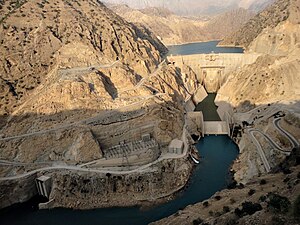
The energy sector in Mekabiri is diverse, with the country relying on a mix of renewable and non-renewable sources to meet its energy needs. Mekabiri has significant solar, wind, and hydropower potential, and the government has made significant investments in these sectors in recent years. Solar energy is a particularly important source of power in Mekabiri, with the country's first solar power plant having been commissioned in 2016. In addition to renewable energy sources, Mekabiri also relies on fossil fuels, including coal and natural gas, to generate electricity.
Transport
Mekabiri has a well-developed infrastructure, with a modern road and highway network, as well as ports and airports that serve as important hubs of trade and transportation. The country is also home to a number of major rail lines, including the high-speed rail service that connects Piri to Mi'irabi.
Media
The media landscape in Mekabiri is diverse, with a mix of state-owned and private media outlets operating in the country. The Mekabirian state operates a number of television and radio stations, and there are also a number of private television and radio stations, as well as a range of newspapers and online media outlets. In general, the media in Mekabiri is subject to state censorship, and journalists who criticize the government or sensitive political topics can face persecution.
Demographics
Ethnic groups
Mekabiri has a population of around 9 million people. The population is relatively young, with a median age of around 30 years. The country has a diverse mix of ethnicities. Most of the people have mixed ancestry in some degree. Because of the country's mixed geography, the ethnic groups and provinces are also separated by geography. The northern highlands share a similar culture. The southern coastal areas are more focused on the sea. Border areas have a strong cultural mix. Everyone born in the country is treated as Mekabirian, independent of heritage. Racism is an unbailable crime. [1] One notable minority group in Mekabiri is the Orinese community, which has a long history in the country. Orioni occupied parts of Mekabiri for many centuries. Since intermarriage between the settlers and the natives was very usual, there are still significant numbers of people of Orinese descent living in Mekabiri, particularly in the south of the country. These communities are concentrated in cities such as Piri and Mi'irabi, and they often speak Oharic as their second language. Many people of Orinese descent in Mekabiri are engaged in trade and commerce, and they have played a significant role in the economic development of the country.
Religion
Religion in Mekabiri.[3]
Mekabiri is a secular state, where the government is not affiliated with any particular religion and does not favour one religion over others. The government does not officially endorse any particular religion, and freedom of religion is protected by law. As a result, the country has a diverse religious landscape, with a variety of faiths being practised. The largest religion in Mekabiri is Juluvanism, followed by Orinese faiths and Salam. There are also a number of people of other faiths living in Mekabiri.
Education
In Mekabiri, children between the ages of 6 and 16 must attend school. The government provides free primary and secondary education, which includes three years of middle school and three years of high school. The Mekabirian education system, which is based on the Miirosi model, emphasizes subjects like maths, science, and literature. Private schools, which may offer a better education but at a higher cost, also exist in Mekabiri. Universities and other higher education institutions, found in cities such as Piri and Mi'irabi, offer higher education in Mekabiri.
Health
Mekabiri offers healthcare through both public and private facilities. The government operates public hospitals and clinics that are open to all citizens. Private hospitals and clinics, which generally provide higher quality care but at a higher cost, are also present in the country. While healthcare in Mekabiri is mostly adequate, access to it may be limited in rural areas. In an effort to improve healthcare access, the government has increased insurance coverage and built new hospitals and clinics.
Culture
Mekabiri has a long literary tradition that draws from both local and colonial influences. Its literature includes poetry, fiction, and non-fiction and often reflects the country's culture and politics. Mekabirian writers have received international acclaim and their work is widely translated. Mekabirian art includes painting, sculpture, and ceramics and is influenced by the country's cultural and historical traditions as well as contemporary themes. Artists from Mekabiri have gained recognition in Mekabiri and abroad. Its music reflects a range of cultural influences, and including genres such as traditional folk music, pop, and hip hop. It is typically a central part of Mekabirian cultural events. Mekabirian cuisine is diverse, with Amutian, Meteorolan, and Oriental influences, and features a variety of spices, herbs, and flavours that mix sweet and savoury tastes. Dishes include kusikusi, tajīnē, and t’ubawī and are known for their use of spices such as cumin, turmeric, and saffron. Football is the most popular sport in Mekabiri, and the country has professional clubs and a national team that has participated in international UENA tournaments. Other sports popular in Mekabiri include basketball, athletics, and boxing.
References
- ↑ 1.0 1.1 NSwiki: Emakera (15 January 2006)
- ↑ OARC 2022 Meeting (20 March 2022)
- ↑ 3.0 3.1 The Federative Popular Republic of Emakera (13 January 2006)
Notes
- ↑ OOC. The population number is the calculated average of Emakera and Pirilao.
- ↑ OOC. The prefix “Per” signifies “house”, evident in names like Ophir, which is conceptualized as an ancient lost city. The infix “Li”, a reversal of “il” sourced from Ilkhan (title), offers intelligibility to the Shakyan indigenous community. Finally, “Nin” is discernible from the etymology of Orioni, establishing a clear connection with Orioni.
- ↑ OOC. Reference to the player behind the retired country of Pirilao.
- ↑ OOC. Reference to the player behind the retired country of Emakera.
- ↑ OOC. Wanted to use the Orinese Phi, but decided to go with Miiros just to snub the old coloniser.
- ↑ OOC. Based on the Yardna River and Karun-3 Dam.


