Zanzali
 Flag
 Coat of Arms
| |
Motto: "ఇల్లీ వాన్తరు అంవెసఁ వాక్యాంటీసి హోంకిఫులి." "Ili wanatru amwesa wakantsi hokifuli." "So that our children may sit in the shade." | |
 Political Map of Zanzali | |
| Capital | Babamamba |
| Largest city | Zanzudu |
| Official languages | ShiMzanzi |
| Recognised regional languages | |
| Ethnic groups | |
| Religion | List of religions
|
| Demonym(s) | Mzanzi (sing.) WaMzanzi (pl.) |
| Government | Kritarchy with democratic and aristocratic characteristics |
| Zuwena binwa Mahiri | |
• Bendhara | Dana mwawa Endeleya |
| Mzuzi mwawa Sartika | |
| Legislature | Fukoshauri |
| Waswiya Mabadi | |
| Ɓaɓada | |
| Independence from the Mutul | |
• Tahamaja colony | 936-1353 CE |
• Pirate republics | 1353-1695 |
• Maok'ab client state | 15 September 1695 - 23 March 1841 |
• Madarakate | 23 March 1878 - present |
| Area | |
• Total area | 698,560 km2 (269,720 sq mi) |
• Water (%) | 9 |
| Population | |
• 2020 census | 44,009,280 |
• Density | 63/km2 (163.2/sq mi) |
| GDP (nominal) | 2020 estimate |
• Total | $1,122,236,640,000 |
• Per capita | $25,500 |
| Gini (2020) | medium |
| HDI (2020) | very high |
| Currency | biya (Z฿) (ZZP) |
| Time zone | UTC+2 |
| Date format | dd/mm/yyyy |
| Driving side | right |
| Calling code | +258 |
| Internet TLD | .ZZ |
Zanzali (/zɑːnzɑːliː/; ShiMzanzi: త్సణ్డజాలే, Tsandzale), officially the Madarakate of Zanzali (ShiMzanzi: మదరకత త్సణ్డజాలే, Madarakata Tsandzale), is a country in southeastern Malaio situated on the Karaihe Sea, bordering Pulau Keramat to the north, Pulacan to the west, and Onekawa-Nukanoa to the east. Its population of 44,009,280 is concentrated on the tropical coast, with much of the rest of its 698,560km2 area being arid and relatively sparsely populated. The capital of Zanzali is Babamamba, while the largest city is Zanzudu. Its majority and official language is ShiMzanzi, the southernmost Mwambao language.
For much of prehistory, Zanzali was occupied by Tuganani peoples, who would eventually be pushed out of the region, or otherwise assimilated, by Komontu migrants who began arriving en mass in the early 500s CE. Beginning in the 10th century CE, the area that is now Zanzali was utilized as a penal colony by the Tahamaja Empire, where criminals and dissidents from throughout the Ozeros region were sent to work mining gemstones and growing coffee and nuts alongside local Komontu and Tuganani tribes. The mixing of these groups gave rise to the WaMzanzi, which today are the largest group in Zanzali. This constant influx of criminal elements led to the region becoming known for its skilled mercenaries, smugglers, and pirates, who eventually became the main authorities in Zanzali after the collapse of the Tahamaja in the 1300s, leading to the rise of many pirate republics in the region. These republics came under the suzerainty of the Mutulese Yajawil of Maok'ab by the late 17th century. In 1841, the Mzanzi republics gained their independence from Maok'ab, and joined in 1863 under a union of religious courts which would evolve into the modern state.
Zanzali's political history has been defined by a unique system of rule by religious judges, called unamuzi, and a "big man" dynamic characterized by spectacle. The Madaraka is offically a unitary state which practices heavy devolution across 9 viceroyalties. Power is balanced between the central judiciary, aristocratic clans, and popular petitions and referenda. Zanzali is a minor power and a member of many international organizations, such as AON, the Forum of Nations, and the Joint Space Agency. It has a developed economy, with a GDP per capita of $25,500, with major industries including tourism, textiles, and hardware manufacturing. Industrial agriculture and food processing is also a major component of the economy, with coffee, seafood, tobacco. and spices, particularly vanilla, being mainstays. Despite a relatively strong economy and high HDI of .804, Zanzali is known for its high income inequality, with a GINI coefficient of 44.3. Likewise, while it ranks well in many international comparisons of quality of life, Zanzali has been criticized for its lack of human rights protections and inconsistent public services.
Etymology
The name Zanzali is derived from the Middle ShiMzanzi word tsandzale (coast), which remains the native name for the country. This word was understood by Tahamajan authorities to be the native name for the region, but there is no historical evidence for its use in this context before the 13th century, records of which primarily come from Tahamajan documents. Other historical names include Zanzudu ("black coast"), Ikomwii ("bad shore"), and Waguguru (from mguguru, "stubborn, brutal"), all reflecting Tahamajan attitudes towards the area's inhabitants.
A person from Zanzali, or a member of its dominant ethnic group, is called an Mzanzi (/əmzɑːnziː/), the plural being WaMzanzi (/wɑːˈ-/).
"Madarakate" entered usage as a formal national title in 1878, being coined a century earlier to describe realms overseen by monastaries and judges, as opposed to Mutulese batabs. It comes from the ShiMzanzi word madaraka, literally "obligations, arrangements", and evokes the cultural and religious responsibilities upon which the Mzanzi state are based.
Geography and climate

Zanzali is approximately 713,600km2 (275,523 square miles) in area, located on the southern shore of the Karaihe Sea in southeastern Malaio. It borders Onekawa-Nukanoa to the east, along the Hanaki River and accompanying swamplands, and the Javinassa peninsula of Pulau Keramat to the north, where the border is partially defined by the Javinassa Mountains, which lower into the Djebe Highlands which form a border with Pulacan to the west.
Zanzali's physical features are characterized by the dichotomy between the wet, tropical coast in the north and the semi-arid, rugged southern interior. Southern Karaihe coastal forests are broken up by coastal swamplands, particularly East Malaioan mangrove forests and Mzanzi flooded savanna, host thousands of diverse plant and animal species and support extensive fishing, agriculture, and tourism industries. The Koo, Mbizi, Ndzeya, and Hanaki rivers (listed west-to-east by the location of their estuaries) are the country's principle waterways, meandering north from the interior hills into the Karaihe Sea, creating numerous lakes, swamps, and floodplains along the way. The Hanaki river is Zanzali's widest river, spanning 22 kilometers (13.6 miles) across at its widest point, while the Koo River is the longest, winding 1220 kilometers (695 miles) from Lake Ntsiɗwe on the country's southwestern border to its outlet near the city of Waguguru.
Annual monsoons from May to November inundate coastal regions, with some areas receiving more than 1500 milimeters (60 inches) of rain annually. While the rainy season is also, on average, the warmer part of the year, it is rare for temperatures on the coast to deviate much outside of the range of 25°C-30°C (77°F-86°F). Moving away from the coast, there is a rapid transition to tropical savanna and miyombo woodlands, accompanied by a rise in elevation. This rise means that most major waterways were not fully navigable, due to rapids and waterfalls, until the construction of a system of locks and canals in the 20th century.
The southern half of the country consists mostly of semi-arid hills, featuring mopane woodlands in the river valleys and drier interior miyombo woodlands in elevated areas. Temperatures are typically similar to the coasts, but rain is much scarcer, with most areas receiving less than 500 milimeters (20 inches) of precipitation annually. This hot, dry hinterland is broken up by high plateaus featuring a contrasting subtropical temperate climate, hosting montane forests and grasslands. Temperatures are comparatively mild and consistent year-round in these regions, usually staying between 10°C-22°C (50°F-76°F). These highlands are the southern terminus of the larger Great Malaioan Rift, a system of lakes, mountains, and highlands running the length of the continent.
Zanzali is also on the southern edge of the Karaihe Ecological Intermediate Zone, a transitional area wherein three distinct biogeographical regions meet: the Malaio Rift savannas, the Ozeros tropical rainforests, and the Onekawan temperate woodlands, all centered around the Karaihe Coral Archipelago, a group of atolls and coral reefs throughout the Karaihe Sea which form one of the largest concentrations of coral and marine life in the world, protected by the internationally-administrated Karaihe International Marine Preserve. The Intermediate Zone features diverse flora and fauna from each of these regions, and Zanzali in particular hosts giraffes, both Ozerosi and Malaioan elephants, rhinoceroses, and other animals which contributes to a thriving eco-tourism sector and zoological community.
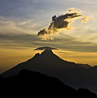
Clouds form over Ruɓaɓa in Haoniyao National Park.

A lone giraffe in Tanegilam National Park.
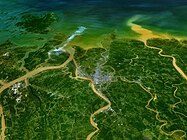
Aerial view of the Ndzeya River Delta.

Birds take flight in a Waguguru mangrove forest.

A boat floats near shallow coral reefs in Waguguru.


History

The eastern coast of Malaio is one of the oldest continually inhabited regions on Earth. Stone tools exacavated from archaeological sites in Zanzali's northwest have been dated back to as early as 100,000 years ago, and fossil specimens elsewhere have been dated as from between 300,000 and 200,000 years ago. Zanzali's indigenous inhabitants are believed to have been various xKhasi-speaking peoples, who practiced hunter-gatherer lifestyles among the interior lakes and savannas.
Approximately 6,000 years ago, Proto-Karaihean speakers began settling the coasts of southeastern Malaio, displacing xKhasi-speakers and pushing them further into the hinterlands. Those who settled in Zanzali and the Javinassa peninsula would eventually develop into the various Tuganani peoples. In the swamplands of northwestern Zanzali, around 3500 BCE, the Tuganani Tiom civilization (a historiographical term) became one of the cradles of civilization. The Tiomi practiced sophisticated environmental engineering through the draining of swamps and irrigation of surrounding areas, allowing them to cultivate crops such as bannanas, sugar cane, and taro. They also practiced a form of early ironworking. Tiomi city-states dotted the coast of the Karaihe Sea and saw frequently trade and conflict with Proto-Onekawan and xKhasi groups on their frontiers. Archaeological finds suggest that Tiomi goods were traded as far as modern Fahran and Haipoon. The Tiom civilization began to decline around 1000 BCE, possibly due to a prolonged drought in the region.
_(14774397124).jpg)
Beginning around 200-500 CE, the final stages of the millennia-long Komontu migrations began to reach southern Malaio. Practicing slash and burn agriculture alongside cattle nomadic pastorialism, they initially migrated south along the coast before reaching what is now Kopikara in western Zanzali. From here, they gradually spread out and began to mix with the local xKhasi and Tuganani populations, the latter of which heavily influenced their agricultural and ironworking techniques, eventually forming the foundations of the modern Mzanzi ethnic group. Further migration southeast along the coast was prevented by aggressive defense of their territory by Onekawan tribes. This is the subject of a mythical folktale in the region which has many variations, but is broadly described a century-long conflict between tribes on both sides of the Hanaki River; among both the WaMzanzi and Onekawans, it is portrayed as a defense of their ways of life against mythical barbarians.
While these Proto-WaMzanzi groups ceased to be nomadic, they did not coalesce into polities much larger than an individual large village during this period. The concept of the "big man" began to crystalize in this time, in which settlements lacked formal leadership beyond those who helped mediate disputes and led the organization of community efforts. Large herds of cattle, which were novel for surrounding Kairehean populations (who had only herded goats and water buffalo), often represented the collective wealth of the village. While Komontu beef was a popular export in the region, cheese took several centuries to catch on. By the late 700s CE, the Proto-Mzanzi were also beginning to serve as middlemen between groups in the southern Malaioan interior and the greater Ozeros Sea, moving gold and gems north, attracting the attention of a budding empire.
Tahamaja period
.jpg)
In the early 900s CE, military expeditions from the Grand Tahamaja began arriving along the coastline of modern Zanzali. Having fully consolidated control over their home islands, Za’gree elites sought avenues for economic expansion throughout the Karaihe and lower Ozeros. This began with trading outposts on the coast, and gradually expanded to include tributaries further inland. However, the inhospitable terrain prevented full-scale colonization beyond the immediate coastline.
Tahamaja rule also brought N'nhivara to the Mzanzi coast. Many WaMzanzi tribes converted en mass, either due to the mass adoption of immigrants or in order to secure favorable arrangements with Tahamajan authorities. Temples and monastaries became centers of political and economic importance, bringing consistent development and resources in their wake. Typically, these Mzanzi converts would syncretize N'nhivara with traditional folk religion, incorporating beliefs about a creator-and-sky god and ancestor worship.

Although the region was initially valued for its connections to the interior's gold and ivory trades, under Tahamaja rule it quickly became a major center for the production of sugarcane and spices (such as nutmeg and cinnamon) as well. Not wanting to enslave large numbers of locals for fear of disrupting the steady flow of valuable goods from the interior, in 933 Pelutama Garaj Ritarja Anukana ordered that coastal plantations be populated with enslaved criminals and political dissedents from throughout the Tahamaja. This resulted in an influx of diverse cultures from throughout the Ozeros as enormous numbers of prisoners were pressed into hard labor each year, ballooning the population. Between 933 and 1000, it is believed that the territory's population grew as much as 300-500%. These imported ethnicities were generally assimilated into existing Proto-Mzanzi clans, either as side effect of Tahamajan bargaining or by choice of individuals either fleeing slavery or purchasing their own freedom, gradually creating a vast ShiMzanzi-speaking creole group which would become the majority population of the region, encompassing Komontu, Tuganani, and countless pan-Ozerosi influences.
The sheer number of criminals and political dissidents among the original colonial population fueled a rich, boisterous tradition of rebellion against Tahamajan authorities. This took many forms, ranging from defiance of colonial borders and taxes to open insurrections. Fraud, smuggling, and free movement of entire groups of people were common. As military service was a relatively straightforward way to secure one's freedom, and generally took less time than saving up enough money to purchase freedom, the region also became famous for its sailors and mercenaries, particularly versatile muwadula-wielding troops who were known to be as capable on horseback as trudging through coastal swamplands. These troops were used extensively by the Tahamaja in military campaigns throughout the Ozeros alongside many other auxiliaries, such as the Onekawan Kaiponu Tauā.
With the eruption of Mt. Siriwang in 1353, the Tahamaja entered a period of violent decline. In the Karaihe, this took the form of local administrators being replaced by regional warlords, often mercenary commanders tied to local clans. By the year 1400, the last vestiges of colonial governance had crumbled and given rise to nearly thirty independent Mzanzi polities.
Majambazi period
majambazi majini ("water thieves")