File:King Site Aerial HRoe 2018.jpg
Jump to navigation
Jump to search


No higher resolution available.
King_Site_Aerial_HRoe_2018.jpg (380 × 253 pixels, file size: 117 KB, MIME type: image/jpeg)
Summary
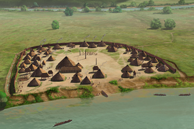
| Description |
English: The King Site (9FL5) is a proto-Mvskoke (Muscogee or Creek confederacy) Barnett Phase Mississippian culture village occupied in the late protohistoric period during a roughly 30-40 year period sometime between the 1540 de Soto entrada and 1600 CE. It is located on a meander bend of the Coosa River in northwestern Georgia and was one of 5 non-mound subsidiary settlements of the"Rome Polity"which was centered on the nearby Nixon mound site (9FL162). The 2.3 hectare village featured a 1300-foot long ditch and palisade, an open plaza with one large post in the center and a 48-foot square ceremonial structure in its northeastern edge, and 40-50 houses surrounding the plaza. Digital illustration, all rights held by the artist, Herb Roe © 2018. |
| Date | |
| Source | Own work |
| Author | Herb Roe |
| Camera location | | View this and other nearby images on: OpenStreetMap |
|---|
Licensing
This file is licensed under the Creative Commons Attribution-Share Alike 4.0 International license.
Attribution: Herb Roe
- You are free:
- to share – to copy, distribute and transmit the work
- to remix – to adapt the work
- Under the following conditions:
- attribution – You must give appropriate credit, provide a link to the license, and indicate if changes were made. You may do so in any reasonable manner, but not in any way that suggests the licensor endorses you or your use.
- share alike – If you remix, transform, or build upon the material, you must distribute your contributions under the same or compatible license as the original.
File history
Click on a date/time to view the file as it appeared at that time.
| Date/Time | Thumbnail | Dimensions | User | Comment | |
|---|---|---|---|---|---|
| current | 00:27, 13 November 2018 | | 380 × 253 (117 KB) | wikimediacommons>Heironymous Rowe | User created page with UploadWizard |
File usage
The following page uses this file: