File:View from a ridge between Segla and Hesten, Senja, Norway, 2014 August.jpg
Jump to navigation
Jump to search


Size of this preview: 800 × 257 pixels. Other resolutions: 320 × 103 pixels | 640 × 206 pixels | 1,024 × 329 pixels | 1,280 × 411 pixels | 2,560 × 822 pixels | 9,500 × 3,052 pixels.
Original file (9,500 × 3,052 pixels, file size: 25.91 MB, MIME type: image/jpeg)
Summary
| Description |
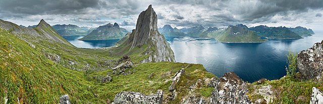
English: A panoramic view from a ridge located between Segla and Hesten mountain summits in the island of Senja, Troms, Norway in 2014 August. The fjord to the left is Øyfjorden with its sounds Trælvika and Ørnfjorden. The fjord to the right is Mefjorden.
Español: Vista panorámica tomada desde una cresta entre las montañas de Segla y Hesten en la isla de Senja, condado de Troms, Noruega, en agosto de 2014. El fiordo Øyfjorden es visible a la izquierda, con sus dos brazos Trælvika y Ørnfjorden. El fiordo a la derecha es Mefjorden.
Français : Vue panoramique depuis une crête entre les monts Segla et Hesten dans l'île de Senja, comté de Troms, en Norvège, en août 2014. Le fjord Øyfjorden est visible à gauche, avec ses deux bras Trælvika et Ørnfjorden. Le fjord Mefjorden est visible à droite.
Русский: Панорамный вид с хребта, расположенного между горными вершинами Сегла и Хестен, на острове Сенья. Фюльке Тромс, Норвегия.
Українська: Панорамний вид із хребта, що розташований між гірськими вершинами Сегла і Хестен, на острові Сенья. Фюльке Тромс, Норвегія.
Português: Vista panorâmica a partir da ilha de Senja, condado de Troms, Noruega, em agosto de 2014. O fiorde Øyfjorden é visível à esquerda com seus dois braços Trælvika e Ørnfjorden. O fiorde à direita é o Mefjorden.
Bosanski: Pogled između Segle i Hestena, ostrvo Senja, Norveška, august 2014. Fjord s desne strane zove se Mefjorden.
Magyar: Kilátás a Segla- és a Hesten-csúcs közötti hegygerincről Senja szigetének fjordjaira (Troms megye, Norvégia)
Italiano: Panorama della cresta montuosa tra il Segla e l'Hesten, Senja in it:Norvegia, sulla destra il fiordo Mefjorden.
한국어: 2014년 8월, 노르웨이 센야 세글라와 헤스텐 사이의 산마루에서 바라본 풍경. 오른쪽의 피오르드가 메피오르덴(Mefjorden)이다.
Svenska: En ås mellan Segla och Hesten på ön Senja i Norge, augusti 2014. Fjorden till höger är Mefjorden. |
| Date | |
| Source | Own work |
| Author | Ximonic (Simo Räsänen) |
| Camera location | | View this and other nearby images on: OpenStreetMap |
|---|

|
NOTE: This image is a panorama consisting of multiple frames that were merged or stitched in software. As a result, this image necessarily underwent some form of digital manipulation. These manipulations may include blending, blurring, cloning, and colour and perspective adjustments. As a result of these adjustments, the image content may be slightly different from reality at the points where multiple images were combined. This manipulation is often required due to lens, perspective, and parallax distortions.
|
Licensing
I, the copyright holder of this work, hereby publish it under the following license:
This file is licensed under the Creative Commons Attribution-Share Alike 4.0 International license.
- You are free:
- to share – to copy, distribute and transmit the work
- to remix – to adapt the work
- Under the following conditions:
- attribution – You must give appropriate credit, provide a link to the license, and indicate if changes were made. You may do so in any reasonable manner, but not in any way that suggests the licensor endorses you or your use.
- share alike – If you remix, transform, or build upon the material, you must distribute your contributions under the same or compatible license as the original.
Assessment
|

| Annotations | This image is annotated: View the annotations at Commons |
This image was selected as picture of the day on Wikimedia Commons for 3 August 2015. It was captioned as follows: English: A view from a ridge between Segla and Hesten, Senja, Norway, 2014 August. The fjord to the right is Mefjorden. Other languages:
Bosanski: Pogled između Segle i Hestena, ostrvo Senja, Norveška, august 2014. Fjord s desne strane zove se Mefjorden. English: A view from a ridge between Segla and Hesten, Senja, Norway, 2014 August. The fjord to the right is Mefjorden. Español: Vista panorámica tomada desde una cresta entre las montañas de Segla y Hesten en la isla de Senja, condado de Troms, Noruega, en agosto de 2014. El fiordo Øyfjorden es visible a la izquierda, con sus dos brazos Trælvika y Ørnfjorden. El fiordo a la derecha es Mefjorden. Italiano: Panorama della cresta montuosa tra il Segla e l'Hesten, Senja in it:Norvegia, sulla destra il fiordo Mefjorden. Magyar: Kilátás a Segla- és a Hesten-csúcs közötti hegygerincről Senja szigetének fjordjaira (Troms megye, Norvégia) Português: Vista panorâmica a partir da ilha de Senja, condado de Troms, Noruega, em agosto de 2014. O fiorde Øyfjorden é visível à esquerda com seus dois braços Trælvika e Ørnfjorden. O fiorde à direita é o Mefjorden. Sunda: Pamandangan legok antara Segla jeung Hesten, Senja, Norwaygia, Agustus 2014. Fjord ka lebah katuahueun Mefjorden. Svenska: En ås mellan Segla och Hesten på ön Senja i Norge, augusti 2014. Fjorden till höger är Mefjorden. Русский: Панорамный вид с хребта, расположенного между горными вершинами Сегла и Хестен, на острове Сенья. Фюльке Тромс, Норвегия. Українська: Панорамний вид із хребта, що розташований між гірськими вершинами Сегла і Хестен, на острові Сенья. Фюльке Тромс, Норвегія, серпень 2014 한국어: 2014년 8월, 노르웨이 센야 세글라와 헤스텐 사이의 산마루에서 바라본 풍경. 오른쪽의 피오르드가 메피오르덴(Mefjorden)이다. |
File history
Click on a date/time to view the file as it appeared at that time.
| Date/Time | Thumbnail | Dimensions | User | Comment | |
|---|---|---|---|---|---|
| current | 15:16, 29 September 2016 | 9,500 × 3,052 (25.91 MB) | wikimediacommons>Ximonic | sRGB |
File usage
The following page uses this file: