File:Willow Flats area and Teton Range in Grand Teton National Park.jpg
Jump to navigation
Jump to search


Size of this preview: 800 × 525 pixels. Other resolutions: 320 × 210 pixels | 640 × 420 pixels | 1,024 × 672 pixels | 1,280 × 840 pixels | 1,811 × 1,189 pixels.
Original file (1,811 × 1,189 pixels, file size: 2.51 MB, MIME type: image/jpeg)
Summary
| Description |
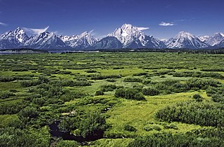
English: Jackson Lake Lodge outlook in the Grand Teton National Park, Wyoming, United States. View over the Willow Flats area to the Teton Range with the Mount Moran and his Skillet Glacier (12605 ft) in the middle.
Deutsch: Blick von der Jackson Lake Lodge über das Feuchtgebiet Willow Flats area zu den Gipfeln des Teton Range Gebirges im Grand Teton National Park, Wyoming, USA.
|
| Date | |
| Source | Own work |
| Author | Michael Gäbler |
| Camera location | | View this and other nearby images on: OpenStreetMap |
|---|
| Camera Model | Olympus OM-1 |
|---|---|
| Film | Kodachrome 25 |
| Scanner | Nikon Coolscan V ED |
|
Licensing
I, Michael Gäbler, the copyright holder of this work, hereby publishes it under the following license:
This file is licensed under the Creative Commons Attribution 3.0 Unported license.
Attribution: I, Michael Gäbler
- You are free:
- to share – to copy, distribute and transmit the work
- to remix – to adapt the work
- Under the following conditions:
- attribution – You must give appropriate credit, provide a link to the license, and indicate if changes were made. You may do so in any reasonable manner, but not in any way that suggests the licensor endorses you or your use.
File history
Click on a date/time to view the file as it appeared at that time.
| Date/Time | Thumbnail | Dimensions | User | Comment | |
|---|---|---|---|---|---|
| current | 21:49, 30 July 2012 | | 1,811 × 1,189 (2.51 MB) | wikimediacommons>Michael Gäbler | Less saturation. |
File usage
The following page uses this file: