User:Occred/Sandbox4: Difference between revisions
m (Changed up the script, made it vertical.) |
No edit summary |
||
| Line 1: | Line 1: | ||
{{Vertical text|}} | |||
<span style="letter-spacing:-0.2em;"> BE</span> | |||
{{Infobox country | {{Infobox country | ||
|native_name = | |native_name = | ||
Latest revision as of 23:25, 20 June 2024
BE
Eschaton of Okredesia
| |
|---|---|
 Flag
| |
Motto:
"Breiking, berning, groing, yerning." ("Breaking, burning, growing, yearning.") | |
| Anthem: Ereynchment fer Aunted Tymes ("Arrangement for Haunted Times") | |
| Map of Okredesia's metropolitanates. Overseas exarchates not shown. Map of Okredesia's metropolitanates. Overseas exarchates not shown. | |
| Capital and largest city | Ys |
| Other languages | Okrish, Ysic |
| Religion | Ysology (official) |
| Demonym(s) | Okrish, Okrisher |
| Government | Anarcho-totalitarian socialist theocracy |
• Archon | Aaa |
| Aaa | |
| Aaa | |
| Legislature | Megasynod |
| Formation | |
• Dagerby culture | c. 25,000 BCE |
• Alweni migration | c. 300 CE |
• Valsian invasions | c. 1300 CE |
• Archimandry period | 1673-1739 |
• Republic period | 1891-1997 |
• Eschaton period | 1997-present |
| Area | |
• | 437,220 km2 (168,810 sq mi) |
| Population | |
• 2023 estimate | 73,890,180[a] |
• Density | 169/km2 (437.7/sq mi) |
| GDP (PPP) | 2023 estimate |
• Total | $3,124,372,371,120 |
• Per capita | $42,284 |
| GDP (nominal) | 2023 estimate |
• Total | $991,606,215,600 |
• Per capita | $13,420 |
| Gini (2021) | 23.3 low |
| HDI (2021) | 0.855 very high |
| Currency | Sol (𐤳) (OKS) |
| Driving side | right |
| Calling code | +23 |
| ISO 3166 code | OK |
| Internet TLD | .ok |

Okredesia (/ɔːkrɛdiːʒiə/ AW-kreh-DEE-zhuh, -DESS-ee-uh) officially the Eschaton of Okredesia (Okrish: Eshadana Åkradeysha), is an island country in the Mazarine Ocean. Most of its land area of 437,22 km2 (168,811 mi2) is characterized by cold, wet, mixed forests and rolling hills. It shares a maritime border with Orleóis, which is also the closest other country to Okredesia, laying 450 kilometers to the west. Much of the population of 73,890,180 is concentrated in the north around the Foss Valley and Lake Sovereign. Ys, the capital, is also the country's largest city. Other major urban centers include Elderon, Elcho, Erneburn, and Phlox.
Okredesia was first inhabited during the Last Glacial Maximum, with megalithic structures submerged in the Dagerby Sea and Great Bay dating to approximately 25,000 years ago. The archaeological record shows a mass die-off occured around 13,000 BCE, leaving the island uninhabited again until the 4th century CE when the Alweni peoples arrived. The Alweni engaged in a hunter-gatherer lifestyle and built their own monumental structures. In the late 1300s, large numbers of Valsians began migrating to Okredesia from eastern Orleóis, conquering and eventually subsuming the Alweni population. During the centuries following the Valsian invasions, power coalesced around the petty kingdoms of Mallow, Lasel, Umber, Begom, and Floret, which are historically referred to as the Pentarchy. Beginning in the mid-1600s, a religious reformation resulted in the entire island uniting for the first time under the Archimandry of Okredesia from 1673 to 1739 before dissolving upon the death of Saint Alinora. The endemic warfare resulting from the Archimandry's collapse fueled the island's industrialization, which in turn caused substantial sociopolitical upheaval. A series of military and political developments, the Convergence, resulted in the formation of the Okredesian Republic in 1891. Rising discontentment due to precarious economic conditions, environmental degradation, and rising authoritarianism led to the Vital Revolution beginning in 1991 with the ensuing Okredesian Civil War ending in 1997 with the victory of the Eldritchites.
Today, Okredesia is a unitary socialist state that has been simultaneously described as an advanced e-democracy and an electronic police state, with low levels of political transparency and religious freedom, but paradoxically high rankings in human development, civil liberties, and democracy. Ysology is the state religion. Okredesia is divided into 13 metropolitanates, which enjoy extraordinary devolved powers, consisting of 256 eparchies and 4096 parishes, as well as 23 overseas exarchates. The country maintains a decentralized socialist economy in which basic needs have been decommodified and all firms are either employee-owned, community-owned, or state-operated. While its nominal GDP per capita is just $13,420, by PPP measurements its GDP per capita is $42,284. Major industries and products include foodstuffs, forest products, commercial vehicles, industrial machinery, electronics, and telecommunications.
Etymology
The origins of the name Okredesia are uncertain. It first emerged into the written record around 1400 CE as Okirdosia, possibly derived from the Middle Alweni word okkido, meaning "to kill, ruin, afflict", and thus could be interpreted as meaning "ruined land" or even "land of the dead". The term was initially used to refer to the area around modern day Elderon and the Foss Valley, likely in reference the devastation wrought by the Valsian invasion of Okredesia which began roughly a century prior, and soon began to be used by the Valsians to refer to the entire island. The modern form, Okredesia, only entered use in the early 1700s, coined and standardized by the govermnent of the Archimandry, and ending the use of other derived words such as Kidosa or Lithasia. With the Great Okredesian Dialect Shift of the late 19th century and subsequent establishment of the Academy for the Okredesian Language in 1910, the native spelling was standardized to Akradeysha.
History
referred to as the Paleopagian Period
Alweni period
Valsian invasions
Archimandry
Republic
Eschaton to present
Geography
The total area of Okredesia, not including overseas exarchates, is 437,220 km2 (168,810 mi2), consisting of the island of Okredesia and its outlaying islets. The island sits between latitudes 48°N and 36°N, and longitudes 92°W and 86°W. Its climate mostly consists of a Template:Wop, which transitions into a humid subtropical climate along the southern coast and around the piedmont of the Talbot Mountains. A small area of warm-summer Mediteranean climate is found around Lerron Sound and the Cinder Islands in the southwest. The moderating effects of the Veta Winds and Thousand Lakes ensure that Rhowyden is unusually warm despite its high latitude, meaning that, even in some of the more northerly regions, productive agriculture is still possible during the short summers. Some regions, such as the Rawl Peninsula, can receive more than 400 cm in snow annually.
Okredesia's topography is defined by its three principle highlands regions: the Foglo Highlands, the Puxen Mountains, and the Talbot Mountains; and the three major rivers that characterize those regions, the Bera River, Foss River, and Wulf River, respectively.
Mown Juni, located in the eastern ridge of the Puxwen Mountains, is the highest point in Okredesia at 616 meters (2023 feet) above sea level. The lowest point in Okredesia is found at Stefapon in the Neverleighs, at 13 meters (42 feet) below sea level.
The Great Bay, located on the west coast between Sharlow and Mereland, is notable because its water is nearly fresh due to the immense drainage of many rivers into it and more brackish seawater being limited by the Dagerby Peninsula and Olan Islands. Aside from the area immediately surrounding the western boundary, the Great Bay's water has salinity levels that allow for safe human consumption. The Great Bay is linked to Lake Sovereign by the Foss River, allowing water travel between the coast and interior of the island.


Mown Juni is the highest point in Rhowyden at 616 meters.

Winter on the shore of Lake Sovereign.
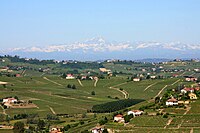
Vineyards in eastern Avony.

Cranes taking flight in a marsh in northern Mereland.

.jpg)


Politics
Law
Foreign policy
Military
Administrative subdivisions
Human rights
Economy
Agriculture
Energy
Tourism
Transportation
Science and technology
Demographics
Ethnic groups
Languages
Religion
Education
Health
Culture
Architecture
Calendar
Cinema
Clothing
Cuisine
Sports
- ↑ Population and area estimates do not include Okredesia's 23 exarchates.