Elizabeth International Airport: Difference between revisions
No edit summary |
No edit summary |
||
| Line 1: | Line 1: | ||
{{Infobox airport | {{Infobox airport | ||
| name = Elizabeth International Airport | | name = Elizabeth International Airport | ||
| image = EIA Logo. | | image = EIA Logo.png | ||
| image-width = 200 | | image-width = 200 | ||
| image2 = File:JFK Aerial Nov 14 2018.jpg | | image2 = File:JFK Aerial Nov 14 2018.jpg | ||
Latest revision as of 04:54, 6 December 2019
Elizabeth International Airport | |||||||||||||||||||||||
|---|---|---|---|---|---|---|---|---|---|---|---|---|---|---|---|---|---|---|---|---|---|---|---|
 | |||||||||||||||||||||||
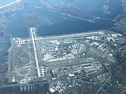
 Aerial shot of EIA on November 14, 2018 | |||||||||||||||||||||||
| Summary | |||||||||||||||||||||||
| Airport type | Public | ||||||||||||||||||||||
| Owner | Elizabeth City | ||||||||||||||||||||||
| Serves | Elizabeth City | ||||||||||||||||||||||
| Location | Elizabeth City, Angola, Ibica | ||||||||||||||||||||||
| Opened | July 1, 1998 | ||||||||||||||||||||||
| Hub for | |||||||||||||||||||||||
| • Summer (DST) | EDT () | ||||||||||||||||||||||
| Elevation AMSL | 13 ft / 4 m | ||||||||||||||||||||||
| Runways | |||||||||||||||||||||||
| |||||||||||||||||||||||
| Helipads | |||||||||||||||||||||||
| |||||||||||||||||||||||
| Statistics (2018) | |||||||||||||||||||||||
| |||||||||||||||||||||||
Source: | |||||||||||||||||||||||
Elizabeth International Airport (colloquially referred to as Elizabeth Airport or EIA) is an international airport in Elizabeth City. It is the primary international airport serving Elizabeth City. The airport is the busiest international air passenger gateway into Ibica having handled just over 61 million passengers in 2018. More than ninety airlines operate from the airport.
The facility opened in 1998 to replace Elizabeth City Prince George Airport, which remains open as the city's reliever airport.
Terminals
EIA has six terminals, containing 128 gates.
The terminal buildings are arranged in a deformed U-shaped wavy pattern around a central area containing parking, a power plant and other airport facilities. The terminals are connected by the AirTrain system and access roads. A 2006 survey found EIA ranked second in overall traveler satisfaction among large airports in Ibica, behind St. Clarke International Airport.
Infrastructure
Runways
Elizabeth International Airport spans 5,200 acres or 21 square kilometers (8.1 sq mi). There are four runways (two pairs of parallel runways) surrounding the airport's central terminal area.
Operational facilities
EIA has over 25 miles (40 km) of taxiways to move aircraft in and around the airfield. The standard width of these taxiways is 75 feet (23 m), with 25 feet (7.6 m) heavy-duty shoulders and 25-foot (7.6 m) erosion control pavements on each side. The taxiways have centerline lights and are generally of asphalt concrete composition 15 to 18 inches (380 to 460 mm) thick. An illuminated sign system provides directional information for taxiing aircraft.
The Air Traffic Control Tower began full FAA operations in October 1999. An Airport Surface Detection Equipment (ASDE) radar unit sits atop the tower. A gas-fired electric cogeneration plant generates electricity for the airport, with an output of about 90 megawatts (120,000 hp). It uses thermal energy from the capture of waste heat to heat and cool all of the passenger terminals and other facilities in the central terminal area. At the time of its completion, the EIA tower, at 320 feet (98 m), was the world's tallest control tower. It was subsequently displaced from that position by towers at other airports in both Ibica and overseas.
Aircraft service facilities include seven aircraft hangars, an engine overhaul building, a 32-million-US-gallon (120,000 m3) aircraft fuel storage facility and a truck garage.
In the last few years, improvements have been made to terminals, roadways and inter-terminal transportation.
Information services
In the immediate vicinity of the airport, parking and other information can be obtained by tuning to a highway advisory radio station at 1630 AM. A second station at 1700 AM provides information on traffic concerns for drivers leaving the airport.
Elizabeth Airport, along with the other Port Authority airport (Prince George), use a uniform style of signage throughout the airport properties. Yellow signs direct passengers to airline gates, ticketing and other flight services; green signs direct passengers to ground transportation services and black signs lead to restrooms, telephones and other passenger amenities. In addition, the Port Authority operates "Welcome Centers" and taxi dispatch booths in each airline terminal, where staff provide customers with information on taxis, limousines, other ground transportation and hotels.
Airlines and destinations
Passenger
| Airlines | Destinations | Refs |
|---|---|---|
| Ibican Airlines | Albany (An), Albany (Pt), Baton Rouge, Boston, Buena Vista, Carsonville, Charlotte (E.M.), Charlotte (Hv), Columbia, Coronado, Cuyoga, Franklin, Iberville, Laffayette, Laurel, Olympia, Parkland, Rhone, Willitya City (JTI), Willmington | |
| Willitya Air | Luxuton, Willitya City-HJW, Willitya City-JTI |
Ground transportation
Rail
Elizabeth Airport is connected to the Elizabeth City Subway, Angola Brightline, and Southern Ibica Railroad by AirTrain. It stops at all terminals, parking lots, hotel shuttle areas, and car rental lots.
Car
Elizabeth Airport is located in southwestern Elizabeth City at the end of Interstate 175. A ring road connects the airport terminals to 175. The airport offers customers over 17,000 parking spaces, included in multi-level parking garages, surface spaces in the Central Terminal Area, a long-term parking lot and valet parking. There are also private off-site parking operators near the airport.
