Garetolia: Difference between revisions
No edit summary |
No edit summary |
||
| Line 70: | Line 70: | ||
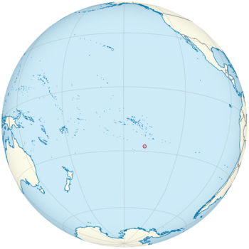
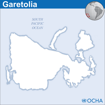
[[Garetolia]] (/ɡærəˈtoliə/); ([[Garetolian language|Garetolian:]] re'Karātōl'ī [[Help:IPA/Garetolian|[rɘˈkɑʳɑtolˈɪ{{)!}}]]); is an {{wp|island nation}} in {{wp|Polynesia (region)|Polynesia}} the {{wp|Pacific Ocean|South Pacific}}. Its closest neighbors are {{wp|French Polynesia}} to the north; the {{wp|Cook Islands}} to the northwest; the {{wp|Pitcairn Islands}} to the northeast; and {{wp|Easter Island}} to the east. Garetolia consists of an archipelago of ten islands and twelve small atolls, amounting to an area of more than 22,500 square kilometers. The most outlying island is [[Masa minor]]. The four main islands amount to 99% of the total population of over 278,000. The capital, [[Ule'eka]], is the nation's primary {{wp|cruise ship}} port. More than three quarters of the population lives on the main island, [[Cona]], whereas others mainly live on the island of [[Mioanhatiin]]. Due to its terrain, the island of [[Noviisida]] is sparsely inhabited. | [[Garetolia]] (/ɡærəˈtoliə/); ([[Garetolian language|Garetolian:]] re'Karātōl'ī [[Help:IPA/Garetolian|[rɘˈkɑʳɑtolˈɪ{{)!}}]]); is an {{wp|island nation}} in {{wp|Polynesia (region)|Polynesia}} the {{wp|Pacific Ocean|South Pacific}}. Its closest neighbors are {{wp|French Polynesia}} to the north; the {{wp|Cook Islands}} to the northwest; the {{wp|Pitcairn Islands}} to the northeast; and {{wp|Easter Island}} to the east. Garetolia consists of an archipelago of ten islands and twelve small atolls, amounting to an area of more than 22,500 square kilometers. The most outlying island is [[Masa minor]]. The four main islands amount to 99% of the total population of over 278,000. The capital, [[Ule'eka]], is the nation's primary {{wp|cruise ship}} port. More than three quarters of the population lives on the main island, [[Cona]], whereas others mainly live on the island of [[Mioanhatiin]]. Due to its terrain, the island of [[Noviisida]] is sparsely inhabited. | ||
Garetolia was formed by volcanic activity some 130 million years ago. Geothermal activity is still visible on many of the islands{{dash}}mostly on Noviisida. Around 500 years ago, the islands were inhabited by {{wp|Polynesian}} peoples. Noviisida, however, was inhabited as early as 1955 due to its rocky and mountainous terrain. {{wp|James Cook}} discovered the island for the {{wp|British Empire}} in 1775, where he helped many people settle. | Garetolia was formed by volcanic activity some 130 million years ago. Geothermal activity is still visible on many of the islands{{dash}}mostly on Noviisida. Around 500 years ago, the islands were inhabited by {{wp|Polynesian}} peoples. Noviisida, however, was inhabited as early as 1955 due to its rocky and mountainous terrain. {{wp|James Cook}} discovered the island for the {{wp|British Empire}} in 1775, where he helped many people settle. However, the first European to land on the island was {{wp|Portugal|Portuguese}} explorer {{wp|Pedro Fernandes de Queirós}} in 1767, where he quickly left due to a volcanic eruption. | ||
Since 1987, Garetolia has maintained adequate diplomacy with many {{wp|France|French}} overseas departments such as {{wp|French Polynesia}} and {{wp|Wallis and Futuna}}. France was the first nation to [[Accession of Garetolia to the United Nations#France|recognize Garetolia]] as a sovereign state. Since its independence, Garetolia has become a member of the {{wp|United Nations}}, the {{wp|Commonwealth of Nations}}, and the {{wp|Pacific Islands Forum}}. | |||
==Etymology== | |||
{{Main|Etymology of Garetolia}} | |||
The etymology of Garetolia is still unknown, but one theory that most scientists refer to is that the word Garetolia comes from an anglicized corruption of the indigenous word "re'Karātōl'ī", which roughly translates to "the land of no problems", as the Polynesians were relatively untouched before the arrival of Fernandes de Queirós. | |||
==History== | |||
{{main|History of Garetolia}} | |||
===Prehistory=== | |||
The prehistory of Garetolia is still somewhat unknown; | |||
Revision as of 06:51, 4 April 2020
This article is incomplete because it is pending further input from participants, or it is a work-in-progress by one author. Please comment on this article's talk page to share your input, comments and questions. Note: To contribute to this article, you may need to seek help from the author(s) of this page. |
Republic of Garetolia Garetolian: Repōkalāka re'Karātōl'ī | |
|---|---|
| Motto: Garetolian: "A'kē la'ō re'Karātōl'ī" "For Garetolia" | |
 | |
 | |
| Capital and largest city | Ule'eka Coordinates: |
| Official languages | English Garetolian (re'Karātōl'ikī) |
| Recognised regional languages | Kaekian (re'Ka'ekī) |
| Ethnic groups (2016) |
|
| Religion (2007) |
|
| Demonym(s) | Garetolian |
| Government | Parliamentary representative democratic republic |
• Monarch | Elizabeth II |
| George Kennel | |
| Quentin Paffinia | |
| Legislature | Parliament |
| Independence | |
• from the United Kingdom | 19 June 1976 |
| Area | |
• Total | 22,559 km2 (8,710 sq mi) (148th) |
• Water (%) | negligible |
| Population | |
• 2019 estimate | 278,000 (161st) |
• 2020 census | 278,532 |
• Density | 12/km2 (31.1/sq mi) (179th) |
| GDP (nominal) | 2020 estimate |
• Total | $274.291 billion |
• Per capita | $962.40 |
| Gini (2019) | medium |
| HDI (2019) | high (106th) |
| Currency | Garetolian Shilling (KTS) |
| Time zone | UTC-10 (KTT) |
• Summer (DST) | UTC-9 (KTST) |
| Driving side | left |
| Calling code | +693 |
| Internet TLD | .kt |
Garetolia (/ɡærəˈtoliə/); (Garetolian: re'Karātōl'ī [rɘˈkɑʳɑtolˈɪ]); is an island nation in Polynesia the South Pacific. Its closest neighbors are French Polynesia to the north; the Cook Islands to the northwest; the Pitcairn Islands to the northeast; and Easter Island to the east. Garetolia consists of an archipelago of ten islands and twelve small atolls, amounting to an area of more than 22,500 square kilometers. The most outlying island is Masa minor. The four main islands amount to 99% of the total population of over 278,000. The capital, Ule'eka, is the nation's primary cruise ship port. More than three quarters of the population lives on the main island, Cona, whereas others mainly live on the island of Mioanhatiin. Due to its terrain, the island of Noviisida is sparsely inhabited.
Garetolia was formed by volcanic activity some 130 million years ago. Geothermal activity is still visible on many of the islands—mostly on Noviisida. Around 500 years ago, the islands were inhabited by Polynesian peoples. Noviisida, however, was inhabited as early as 1955 due to its rocky and mountainous terrain. James Cook discovered the island for the British Empire in 1775, where he helped many people settle. However, the first European to land on the island was Portuguese explorer Pedro Fernandes de Queirós in 1767, where he quickly left due to a volcanic eruption.
Since 1987, Garetolia has maintained adequate diplomacy with many French overseas departments such as French Polynesia and Wallis and Futuna. France was the first nation to recognize Garetolia as a sovereign state. Since its independence, Garetolia has become a member of the United Nations, the Commonwealth of Nations, and the Pacific Islands Forum.
Etymology
The etymology of Garetolia is still unknown, but one theory that most scientists refer to is that the word Garetolia comes from an anglicized corruption of the indigenous word "re'Karātōl'ī", which roughly translates to "the land of no problems", as the Polynesians were relatively untouched before the arrival of Fernandes de Queirós.
History
Prehistory
The prehistory of Garetolia is still somewhat unknown;

