Kalmov: Difference between revisions
Jump to navigation
Jump to search
m (Eras Category) |
|||
| Line 213: | Line 213: | ||
text | text | ||
[[Category:Eras]] | |||
[[Category:Korova]] | [[Category:Korova]] | ||
[[Category:Subdivisions in Eras]] | [[Category:Subdivisions in Eras]] | ||
Revision as of 07:04, 25 November 2020
This article is incomplete because it is pending further input from participants, or it is a work-in-progress by one author. Please comment on this article's talk page to share your input, comments and questions. Note: To contribute to this article, you may need to seek help from the author(s) of this page. |
Kalmov | |
|---|---|
| Nickname: Hills of the Ashen Men | |
| Motto: TEXT | |
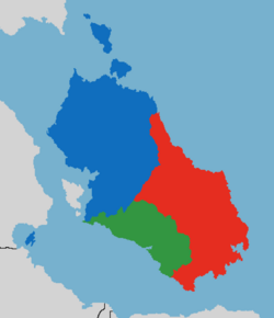
 Map of the Korovan cultural nations, with Kalmov in blue. | |
| Country | Korova |
| Capital | Susli |
| Founded | 833 |
| Founded by | Halfand Kalmov |
| Cultural Centre | Koyvas |
| Government | |
| • Body | Committee of the Kalmov Cultural Nation |
| • Committee Chairperson | Simian Lindström |
| • Deputy Committee Chairperson | Olka Sjöberg |
| Area | |
| • Land | 91,316 km2 (35,257 sq mi) |
| Highest elevation | 2,970 m (9,740 ft) |
| Population (2020) | |
| • Total | 5,439,446 |
| • Density | 60/km2 (200/sq mi) |
| estimate | |
| Demonym | Kalmoviy |
| Time zone | SET +2 |
| ISO 3166 code | KR-KV |
| Website | www.kalmovnation.co.kr |
This is a Summary.
Etymology
History
Prehistory
text
Bayardiy Northern Novaya
text (up to 830)
Zelstoviy Refugee Princes
text (830+, the main principalities were bakhta, penza, and tuvosk)
Late Medieval period
text
Kalmov under Zelstova
text (eaten in 1698)
Tyranny of Korova
text (eaten in 1813)
Modern Kalmov within Korova
text
Korovan Anarchy
text
Geography
text
Topography
text
Climate
text
Biodiversity
text
Administrative Divisions
text
Demographics
Population
text
Language
text
Religion
text
Race
text
Largest cities and towns
template
Economy
text
Education
Transport
International trade
text
Tourism
text
Culture
text
Literature
text
Art
text
Music
text
Media
text
Cuisine
text
Sport
text
Rock climbing
text
Winter sports
text

