Template:GNMap: Difference between revisions
Jump to navigation
Jump to search
No edit summary |
No edit summary |
||
| Line 1: | Line 1: | ||
<div style="font-size:75%"> | <div style="font-size:75%"> | ||
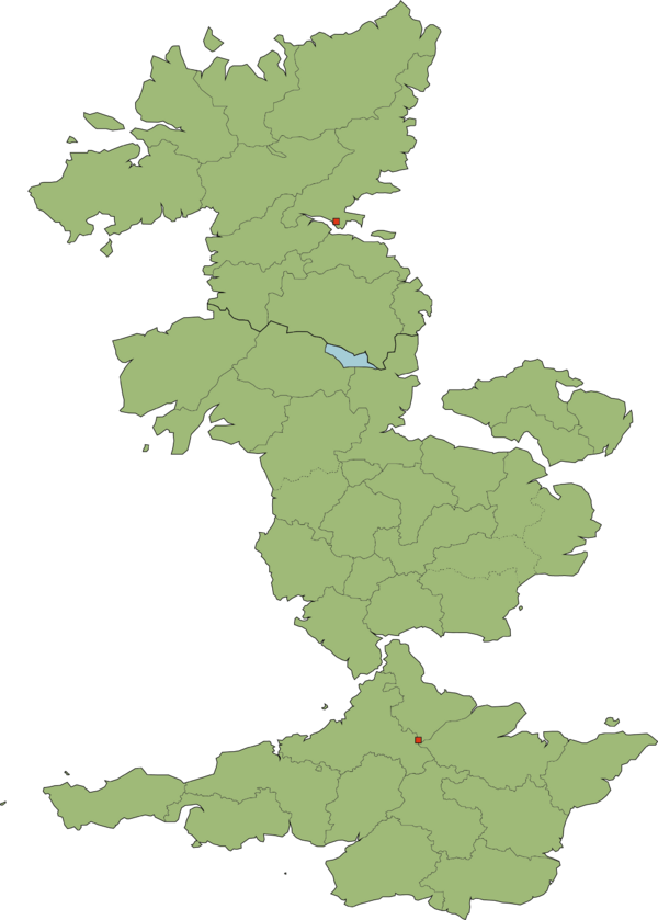
{{Image label begin|image=GNMapWiki.png|width=600|float=left|link=}} | {{Image label begin|image=GNMapWiki.png|width=600|float=left|link=}} | ||
{{Image label|x=- | {{Image label|x=-442|y=-448|scale={{{width|-1}}}|text=Aceshire-<br>Northannering}} | ||
{{Image label|x=- | {{Image label|x=-409.5|y=-539|scale={{{width|-1}}}|text=Aceshire-<br>Southannering}} | ||
{{Image label|x=-490|y=-475|scale={{{width|-1}}}|text=Aceshire-<br>Eastannering}} | {{Image label|x=-490|y=-475|scale={{{width|-1}}}|text=Aceshire-<br>Eastannering}} | ||
{{Image label|x=-421|y=-503|scale={{{width|-1}}}|text=Aceshire-<br>Midannering}} | {{Image label|x=-421|y=-503|scale={{{width|-1}}}|text=Aceshire-<br>Midannering}} | ||
{{Image label|x=-252|y=-514|scale={{{width|-1}}}|text=Almeshire}} | {{Image label|x=-252|y=-514|scale={{{width|-1}}}|text=Almeshire}} | ||
{{Image label|x=- | {{Image label|x=-408|y=-428|scale={{{width|-1}}}|text=Barard}} | ||
{{Image label|x=-323|y=-785|scale={{{width|-1}}}|text=Barminstershire}} | {{Image label|x=-323|y=-785|scale={{{width|-1}}}|text=Barminstershire}} | ||
{{Image label|x=-375|y=-742|scale={{{width|-1}}}|text=Bentshire}} | {{Image label|x=-375|y=-742|scale={{{width|-1}}}|text=Bentshire}} | ||
| Line 33: | Line 33: | ||
{{Image label|x=-428|y=-804|scale={{{width|-1}}}|text=Walecestershire}} | {{Image label|x=-428|y=-804|scale={{{width|-1}}}|text=Walecestershire}} | ||
{{Image label|x=-397|y=-671|scale={{{width|-1}}}|text=Teyshire}} | {{Image label|x=-397|y=-671|scale={{{width|-1}}}|text=Teyshire}} | ||
{{Image label|x=- | {{Image label|x=-88|y=-734|scale={{{width|-1}}}|text=Towshire}} | ||
{{Image label|x=-451|y=-352|scale={{{width|-1}}}|text=County<br>Allells}} | {{Image label|x=-451|y=-352|scale={{{width|-1}}}|text=County<br>Allells}} | ||
{{Image label|x=-470|y=-392|scale={{{width|-1}}}|text=Cardenbridge}} | {{Image label|x=-470|y=-392|scale={{{width|-1}}}|text=Cardenbridge}} | ||
| Line 41: | Line 41: | ||
{{Image label|x=-285|y=-277|scale={{{width|-1}}}|text=Esxshire}} | {{Image label|x=-285|y=-277|scale={{{width|-1}}}|text=Esxshire}} | ||
{{Image label|x=-200|y=-90|scale={{{width|-1}}}|text=Ganningshire}} | {{Image label|x=-200|y=-90|scale={{{width|-1}}}|text=Ganningshire}} | ||
{{Image label|x=-206|y=-262|scale={{{width|-1}}}|text= | {{Image label|x=-206|y=-262|scale={{{width|-1}}}|text=Westmarch}} | ||
{{Image label|x=-84|y=-171|scale={{{width|-1}}}|text=Minnerland}} | {{Image label|x=-84|y=-171|scale={{{width|-1}}}|text=Minnerland}} | ||
{{Image label|x=-211|y=-163|scale={{{width|-1}}}|text=Rhightonshire}} | {{Image label|x=-211|y=-163|scale={{{width|-1}}}|text=Rhightonshire}} | ||
{{Image label|x=-288|y=-69|scale={{{width|-1}}}|text=Rocklehamshire}} | {{Image label|x=-288|y=-69|scale={{{width|-1}}}|text=Rocklehamshire}} | ||
{{Image label|x=- | {{Image label|x=-310|y=-150|scale={{{width|-1}}}|text=Cothen-<br>Wainsey}} | ||
{{Image label|x=- | {{Image label|x=-150|y=-100|scale={{{width|-1}}}|text=Tolland}} | ||
{{Image label|x=-285|y=-190|scale={{{width|-1}}}|text='''RHISE'''}} | |||
{{Image label|x=-350|y=-690|scale={{{width|-1}}}|text='''[[Lendert-with-Cadell|LENDERT-<br>WITH-CADELL]]'''}} | |||
</div></div> | </div></div> | ||
Revision as of 04:11, 30 January 2021
Aceshire-
Northannering
Northannering
Aceshire-
Southannering
Southannering
Aceshire-
Eastannering
Eastannering
Aceshire-
Midannering
Midannering
Almeshire
Barard
Barminstershire
Bentshire
Derhamshire
Eamshire
Enley
Essingfordshire
Fawnshire
Gortland
Harvickshire
Herstlow
Northeymeadshire
Southeymeadshire
Igoxeter
Larkshire
Leaton
Merst
Narland
Norsax
Poltland
Redwickshire
Seffet
Sulthey
Suthrepourdeland
Swent
Walecestershire
Teyshire
Towshire
County
Allells
Allells
Cardenbridge
Mure
Bissex-
Cranshire
Cranshire
Despenshire
Esxshire
Ganningshire
Westmarch
Minnerland
Rhightonshire
Rocklehamshire
Cothen-
Wainsey
Wainsey
Tolland
RHISE