User:Aurrica/Sandbox: Difference between revisions
Jump to navigation
Jump to search
No edit summary |
No edit summary |
||
| (20 intermediate revisions by the same user not shown) | |||
| Line 1: | Line 1: | ||
{| class="wikitable" | {| class="wikitable" | ||
!Map!!Name and flag!!Administrative centre!!Code | |||
|- | |- | ||
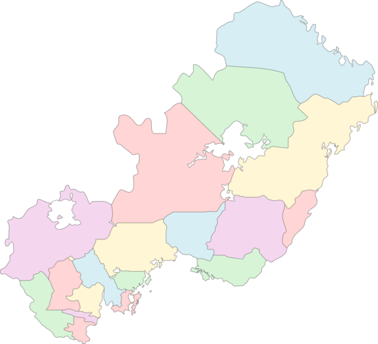
! | | rowspan="21" |<center>{{Hullivia labelled map}}</center> | ||
! colspan="3" |[[Administrative divisions of Hullivia|Communes of Hullivia]] | |||
|- | |- | ||
| | |[[File:Flag_of_Albe.png|22px]] [[Albe (Hullivia)|Albe]]||[[Gladbach]]||AL | ||
|- | |- | ||
| [[ | |[[File:Flag_of_Ebengäu.png|22px]] [[Ebengäu]]||[[Heidelstrand]]||EB | ||
|- | |- | ||
| [[ | |[[File:Flag_of_Holzküste.png|22px]] [[Holzküste]]||[[Otthafen]]||HK | ||
|- | |- | ||
| [[ | |[[File:Flag_of_Jadeküste.png|22px]] [[Jadeküste]]||[[Neu-Kolreuth]]||JK | ||
|- | |- | ||
| [[ | |[[File:Flag_of_Johannsland.png|22px]] [[Johannsland]]||[[Plattau]]||JO | ||
|- | |- | ||
| [[ | |[[File:Flag_of_Landshut.png|22px]] [[Landshut]]||[[Pôlterswil]]||LA | ||
|- | |- | ||
| [[ | |[[File:Flag_of_Leyenland.png|22px]] [[Leyenland]]||[[Fürstenmeyer]]||LY | ||
|- | |- | ||
| [[ | |[[File:Flag_of_Marani.png|22px]] [[Marani]]||[[Uheitawa]]||MA | ||
|- | |- | ||
| [[ | |[[File:Flag_of_Mittelhüllivien.png|22px]] [[Central Hullivia]]||[[Ludwigsdorf]]||MH | ||
|- | |- | ||
| [[ | |[[File:Flag_of_Neueböden.png|22px]] [[Neueböden]]||[[Warmwasser]]||NB | ||
|- | |- | ||
| [[ | |[[File:Flag_of_Neu-Elbenweis.png|22px]] [[New Elbenweis]]||[[Antipolis]]||NE | ||
|- | |- | ||
| [[ | |[[File:Flag_of_Osternburg.png|22px]] [[Osternburg Commune|Osternburg]]||[[Osternburg]]||OB | ||
|- | |- | ||
| [[ | |[[File:Flag_of_Sparten.png|22px]] [[Sparten]]||[[Horvathstadt]]||SP | ||
|- | |- | ||
| [[ | |[[File:Flag_of_Gemeinde_Süd.png|22px]] [[South Commune (Hullivia)|South]]||[[Rio Verde]]||SD | ||
|- | |- | ||
| [[ | |[[File:Flag_of_Taguaschu.png|22px]] [[Taguaschu]]||[[Pytaiva]]||TA | ||
|- | |- | ||
| [[ | |[[File:Flag_of_Tiaraju.png|22px]] [[Tiaraju Commune|Tiaraju]]||[[Tiarajustadt]]||TI | ||
|- | |- | ||
| [[ | |[[File:Flag_of_Trockengras.png|22px]] [[Trockengras]]||[[Rudolfsburg]]||TG | ||
|- | |- | ||
| [[ | |[[File:Flag_of_Zuckerland.png|22px]] [[Zuckerland]]||[[Robertsau]]||ZU | ||
|- | |- | ||
| [[ | ! colspan="3" |[[Administrative divisions of Hullivia|Territories with special status]] | ||
|- | |- | ||
| [[ | |[[File:Flag of the Horvath District.png|22px]] [[Horvath District]]||[[Die Friede]]||HD | ||
|- | |- | ||
|} | |} | ||
Latest revision as of 00:38, 8 February 2021
| Map | Name and flag | Administrative centre | Code |
|---|---|---|---|
| Communes of Hullivia | |||
| Gladbach | AL | ||
| Heidelstrand | EB | ||
| Otthafen | HK | ||
| Neu-Kolreuth | JK | ||
| Plattau | JO | ||
| Pôlterswil | LA | ||
| Fürstenmeyer | LY | ||
| Uheitawa | MA | ||
| Ludwigsdorf | MH | ||
| Warmwasser | NB | ||
| Antipolis | NE | ||
| Osternburg | OB | ||
| Horvathstadt | SP | ||
| Rio Verde | SD | ||
| Pytaiva | TA | ||
| Tiarajustadt | TI | ||
| Rudolfsburg | TG | ||
| Robertsau | ZU | ||
| Territories with special status | |||
| Die Friede | HD | ||
