Frestovenia: Difference between revisions
Jump to navigation
Jump to search
Frestovenia (talk | contribs) No edit summary |
Frestovenia (talk | contribs) No edit summary |
||
| (2 intermediate revisions by the same user not shown) | |||
| Line 1: | Line 1: | ||
{{Infobox country | {{Infobox country | ||
|conventional_long_name = Republic of Frestovenia | |conventional_long_name = Republic of Frestovenia | ||
|native_name = '' | |native_name = ''Republik av Frestoya'' <small>([[Frestovenian language|Frestovenian]])</small> <br> ''Republiku av Frestoya'' <small>([[Ostajen language|Ostajen]])</small> | ||
|common_name = Frestovenia | |common_name = Frestovenia | ||
|image_flag = Flag | |image_flag = Flag of Frestovenia.png | ||
|alt_flag = [[Flag]] | |alt_flag = [[Flag]] | ||
|image_coat = Coat of Arms of the Republic of Frestovenia.png | |image_coat = [[file:Coat of Arms of the Republic of Frestovenia.png|60px]] | ||
|alt_coat = [[Coast of Arms]] | |alt_coat = [[Coast of Arms]] | ||
|symbol_type = Coat of Arms | |symbol_type = Coat of Arms | ||
| Line 14: | Line 13: | ||
|other_symbol_type = | |other_symbol_type = | ||
|other_symbol = | |other_symbol = | ||
|image_map = | |image_map = [[file:Frestovenia location map.png|250px]] | ||
|alt_map = | |alt_map = | ||
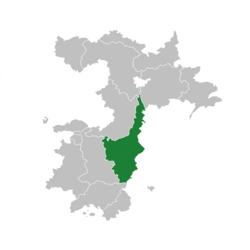
|map_caption = | |map_caption = Location of Frestovenia (green) | ||
|image_map2 = | |image_map2 = | ||
|alt_map2 = | |alt_map2 = | ||
| Line 30: | Line 29: | ||
|ethnic_groups_year = | |ethnic_groups_year = | ||
|demonym = Frestovenian | |demonym = Frestovenian | ||
|government_type = Unitary parliamentary | |government_type = Unitary parliamentary republic | ||
|leader_title1 = | |leader_title1 = President | ||
|leader_name1 = {{nowrap|[[ | |leader_name1 = {{nowrap|[[Ran Holborg]]}} | ||
|leader_title2 = Prime Minister | |leader_title2 = Prime Minister | ||
|leader_name2 = [[Fredrik Sagenhus]] | |leader_name2 = [[Fredrik Sagenhus]] | ||
| Line 53: | Line 52: | ||
|area_magnitude = | |area_magnitude = | ||
|area = | |area = | ||
|area_km2 = | |area_km2 = 412,036 | ||
|area_sq_mi = 123,561 | |area_sq_mi = 123,561 | ||
|area_footnote = | |area_footnote = | ||
|percent_water = | |percent_water = 5.91 | ||
|area_label = Total | |area_label = Total | ||
|area_label2 = | |area_label2 = | ||
|area_dabodyalign = | |area_dabodyalign = | ||
|population_estimate = | |population_estimate = 11,990,264 | ||
|population_estimate_rank = | |population_estimate_rank = | ||
|population_estimate_year = | |population_estimate_year = 2021 | ||
|population_census = | |population_census = | ||
|population_census_year = | |population_census_year = | ||
| Line 88: | Line 87: | ||
|HDI_change = | |HDI_change = | ||
|HDI_category = | |HDI_category = | ||
|currency = | |currency = Frestoya Kroner | ||
|currency_code = FK | |currency_code = FK | ||
|time_zone = FCT +0 | |time_zone = FCT +0 | ||
| Line 100: | Line 99: | ||
|cctld = .fre | |cctld = .fre | ||
|calling_code = +22 | |calling_code = +22 | ||
|national_animal = | |national_animal = | ||
|image_map3 = | |image_map3 = | ||
|alt_map3 = | |alt_map3 = | ||
| Line 106: | Line 105: | ||
}} | }} | ||
[[Frestovenia]], officially | [[Frestovenia]], officially the Republic of Frestovenia ([[Frestovenian language|Frestovenian]]: Republik av Frestoya), is a country located in the northwest of [[Esportiva]]. It is bordered to the north by [[Zeta Reka and Hugeltaldom]], to the northeast by [[Varmelle]], to the east by the [[Hollander Sea]], to the south by [[Mattijana]], and to the west by [[Appalachia]]. Frestovenia has total population of 11.7 million and a low population density of 14 inhabitants per square kilometre. [[Asvard]], the capital of Frestovenia, and [[Varenskane]] are the largest cities and urban areas in the country. Other major cities are [[Lungesere]], [[Koplinger]], [[Hablingsvard]] and [[Ostbare]]. 72% of the population lives in the central and southern part of the country. | ||
[[ | |||
Latest revision as of 19:06, 2 March 2021
Republic of Frestovenia | |
|---|---|
| Anthem: Nasjonalsang av Frestovenia | |
 Location of Frestovenia (green) | |
| Capital and largest city | Asvard |
| Official languages | Frestovenian |
| Recognised regional languages | Northern Asvardian |
| Ethnic groups | 98.3% Frestovenian 1.7% Other |
| Demonym(s) | Frestovenian |
| Government | Unitary parliamentary republic |
• President | Ran Holborg |
• Prime Minister | Fredrik Sagenhus |
| Legislature | Parliament |
| Area | |
• Total | 412,036 km2 (159,088 sq mi) |
• Water (%) | 5.91 |
| Population | |
• 2021 estimate | 11,990,264 |
| Currency | Frestoya Kroner (FK) |
| Time zone | FCT +0 |
• Summer (DST) | FCT +1 |
| Date format | dd.mm.yyyy |
| Driving side | right |
| Calling code | +22 |
| Internet TLD | .fre |
Frestovenia, officially the Republic of Frestovenia (Frestovenian: Republik av Frestoya), is a country located in the northwest of Esportiva. It is bordered to the north by Zeta Reka and Hugeltaldom, to the northeast by Varmelle, to the east by the Hollander Sea, to the south by Mattijana, and to the west by Appalachia. Frestovenia has total population of 11.7 million and a low population density of 14 inhabitants per square kilometre. Asvard, the capital of Frestovenia, and Varenskane are the largest cities and urban areas in the country. Other major cities are Lungesere, Koplinger, Hablingsvard and Ostbare. 72% of the population lives in the central and southern part of the country.

