User:Hifax/Sandbox: Difference between revisions

Jump to navigation Jump to search
No edit summary
Line 1: Line 1:
{{Infobox country
<center>
|micronation =        <!--yes if a micronation-->
{| style="float:left; border:0; margin:2.6em 0 0;"
|conventional_long_name = State of Lehavim
|-
|native_name =    לְהָבִים ‎מְדִינַת <small>({{wp|Hebrew|Lehavimi}})</small><br>''Medinat Lehavim''
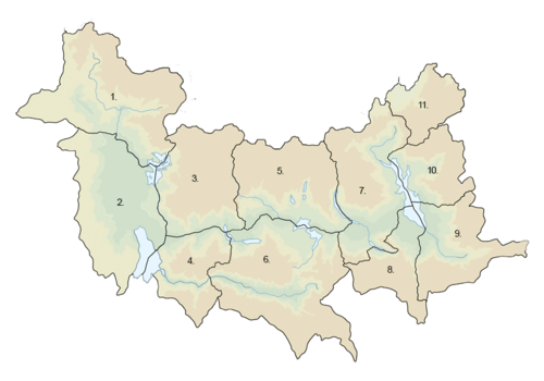
| style="vertical-align:top; text-align:left;"|[[File:Nidwalden Counties.png|500 px|Nidwaldeser counties]]
|common_name =     Lehavim
|}
|status =            <!--Status of country, especially useful for micronations-->
{| class="wikitable" style="text-align:left; font-size:90%;"
|image_flag =         Flag of Lehavim.png
|- style="font-size:100%; text-align:right;"
|alt_flag =          <!--alt text for flag (text shown when pointer hovers over flag)-->
! colspan="2" | Canton !! !! Capital
|flag_border =        <!--set to no to disable border around the flag-->
|-
|image_flag2 =        <!--e.g. Second-flag of country.svg-->
| style="border-right:0;"| [[File:Wappen Genf matt.svg|14px]] || style="border-left:0;"| [[Rhine]] || 1 || [[Cologne]]
|alt_flag2 =          <!--alt text for second flag-->
|-
|flag2_border =      <!--set to no to disable border around the flag-->
| style="border-right:0;"| [[File:Kalmar län vapen.svg|14px]] || style="border-left:0;"| [[Grevenmacher]] || 2 || [[Vaduz]]
|image_coat =         <!--e.g. Coat of arms of country.svg-->
|-
|alt_coat =           <!--alt text for coat of arms-->
| style="border-right:0;"| [[File:Wappen Thurgau matt.svg|14px]] || style="border-left:0;"| [[Vorarlberg]] || 3 || [[Feldkirch]]
|symbol_type =        <!--emblem, seal, etc (if not a coat of arms)-->
|-
|national_motto =     <!--in inverted commas and wikilinked if link exists-->
| style="border-right:0;"| [[File:Wappen Landkreis Starnberg.svg|14px]] || style="border-left:0;"| [[Wiltz]] || 4 || Zell am See
|englishmotto =      <!--English language version of motto-->
|-
|national_anthem =   <!--in inverted commas and wikilinked if link exists-->
| style="border-right:0;"| [[File:St_Moritz_wappen.svg|14px]] || style="border-left:0;"| [[Fribourg]] || 5 || [[Lech]]
|royal_anthem =      <!--in inverted commas and wikilinked if link exists-->
|-
|other_symbol_type =  <!--Use if a further symbol exists, e.g. hymn-->
| style="border-right:0;"| [[File:Blekinge vapen.svg|14px]] || style="border-left:0;"| [[Bergig]] || 6 || [[Bremen]]
|other_symbol =
|-
|image_map =          <!--e.g. LocationCountry.svg-->
| style="border-right:0;"| [[File:Halland vapen.svg|14px]] || style="border-left:0;"| [[Diekrich]] || 7 || [[Innsein]]  
|loctext =            <!--text description of location of country-->
|-
|alt_map =            <!--alt text for map-->
| style="border-right:0;"| [[File:Wappen Glarus matt.svg|14px]] || style="border-left:0;"| [[Solothurn]] || 8 || [[Aspen]]  
|map_caption =        <!--Caption to place below map-->
|-
|image_map2 =         <!--Another map, if required-->
| style="border-right:0;"| [[File:Gotland vapen.svg|14px]] || style="border-left:0;"| [[Saanen]] || 9 || [[Erzberg]]
|alt_map2 =          <!--alt text for second map-->
|-
|map_caption2 =      <!--Caption to place below second map-->
| style="border-right:0;"| [[File:Wappen Schaffhausen matt.svg|14px]] || style="border-left:0;"| [[Thurgau]] || 10 || [[Saint Moritz]]
|capital =            Habafar
|-
|coordinates =       <!-- Coordinates for capital, using {{tl|coord}} -->
| style="border-right:0;"| [[File:Wappen Zürich matt.svg|14px]] || style="border-left:0;"| [[Schaffhausen]] || 11 || [[Glarus]]  
|largest_city =      Habafar
|}
|largest_settlement_type = largest city
</center>
|largest_settlement =
|official_languages = {{wp|Hebrew|Lehavimi}}
|national_languages = <!--Country/territory-wide languages recognised but not necessarily in country/territory-wide law, etc-->
|regional_languages = <!--Languages recognised or associated with particular regions within the country/territory-->
|languages_type =    <!--Use to specify a further type of language, if not official, national or regional-->
|languages =          <!--Languages of the further type-->
|languages_sub =     <!--Is this further type of language a sub-item of the previous non-sub type? ("yes" or "no")-->
|languages2_type =    <!--Another further type of language-->
|languages2 =        <!--Languages of this second further type-->
|languages2_sub =    <!--Is the second alternative type of languages a sub-item of the previous non-sub type? ("yes" or "no")-->
|ethnic_groups =      <!--List/breakdown of ethnic groups within the country/territory-->
|ethnic_groups_year = <!--Year of ethnic groups data (if provided)-->
|ethnic_groups_ref =  <!--(for any ref/s to associate with ethnic groups data)-->
|religion =           <!--Religion-->
|religion_year =      <!--Year of religion data (if provided)-->
|religion_ref =      <!--(for any ref/s to associate with religion data)-->
|demonym =            Lehavimi
|government_type =   {{wp|Unitary}} {{wp|parliamentary}} {{wp|constitutional}} {{wp|republic}}
|leader_title1 =      {{wp|President}}
|leader_name1 = Lavan Hefetz
|leader_title2 =      {{wp|Premier}}
|leader_name2 = Irina Fleischer
|leader_title3 =      [[Knesset (Lehavim)|Knesset Speaker]]
|leader_name3 = Ahron Zahavy
<!--......-->
|leader_title14 =     <!--(up to 14 distinct leaders may be included)-->
|leader_name14 =
|legislature =        [[Knesset (Lehavim)|Knesset]]
|upper_house =       <!--Name of governing body's upper house, if given (e.g. "Senate")-->
|lower_house =        <!--Name of governing body's lower house, if given (e.g. "Chamber of Deputies")-->
|sovereignty_type =  <!--Brief description of country/territory's status ("Independence [from...]", "Autonomous province [of...]", etc)-->
|sovereignty_note =
|established_event1 = <!--First key event in history of country/territory's status or formation-->
|established_date1 =  <!--Date of first key event-->
|established_event2 = <!--Second key event-->
|established_date2 =  <!--Date of second key event-->
<!--......-->
|established_event13 = <!--(up to 13 distinct events may be included)-->
|established_date13 =
|area_rank =
|area =              <!--Major area size (in [[Template:convert]] either km2 or sqmi first)-->
|area_km2 =          10,452
|area_sq_mi =         <!--Area in square mi (requires area_km2)-->
|area_footnote =      <!--Optional footnote for area-->
|percent_water =
|area_label =        <!--Label under "Area" (default is "Total")-->
|area_label2 =        <!--Label below area_label (optional)-->
|area_data2 =        <!--Text after area_label2 (optional)-->
|population_estimate = 6,859,408
|population_estimate_rank =
|population_estimate_year = 2020
|population_census = 5,122,641
|population_census_year = 2018
|population_density_km2 = 560
|population_density_sq_mi =
|population_density_rank =  
|nummembers =        <!--An alternative to population for micronation-->
|GDP_PPP =            $310.743 billion
|GDP_PPP_rank =
|GDP_PPP_year = 2020
|GDP_PPP_per_capita = $29,045
|GDP_PPP_per_capita_rank =
|GDP_nominal = $194.376 billion
|GDP_nominal_rank =
|GDP_nominal_year = 2020
|GDP_nominal_per_capita = $18,168
|GDP_nominal_per_capita_rank =
|Gini =              31.0
|Gini_ref =          <!--(for any ref/s to associate with Gini number)-->
|Gini_rank =
|Gini_year = 2020
|HDI_year =          <!-- Please use the year to which the data refers, not the publication year-->
|HDI =                0.812
|HDI_change =        increase
|HDI_rank =
|HDI_ref =            <!--(for any ref/s to associate with HDI number)-->
|currency =          Shekel
|currency_code =      <!--ISO 4217 code/s for currency/ies (each usually three capital letters)-->
|time_zone =          <!--e.g. GMT, PST, AST, etc, etc (wikilinked if possible)-->
|utc_offset =         <!--in the form "+N", where N is number of hours offset-->
|time_zone_DST =      <!--Link to DST (Daylight Saving Time) used, otherwise leave empty-->
|utc_offset_DST =    <!--in the form "+N", where N is number of hours offset-->
|DST_note =          <!--Optional note regarding DST use-->
|antipodes =          <!--Place/s exactly on the opposite side of the world to country/territory-->
|date_format =        <!--all-numeric date format and era, such as [[Common Era|CE]], [[Anno Domini|AD]], [[Hijri year|AH]], etc.; e.g. {{abbr|yyyy|year}}-{{abbr|mm|month}}-{{abbr|dd|day}} ([[Anno Domini|AD]]) -->
|electricity =        <!--e.g. "230 V–50 Hz"-->
|drives_on =         <!--"right" or "left" (side of road)-->
|cctld =              <!--Internet country code top-level domain identifier (e.g. [[.br]], [[.de]], etc)
|iso3166code =       <!--ISO code only; no extra text. Use to override default from common_name parameter above; omit using "omit".-->
|calling_code =      <!--e.g. [[+1]], [[+531]], [[+44]], etc-->
|patron_saint =      <!--Use patron_saints for multiple-->
|image_map3 =         <!--Optional third map position, e.g. for use with reference to footnotes below it-->
|alt_map3 =          <!--alt text for third map position-->
|footnote_a =        <!--For any footnote <sup>a</sup> used above-->
|footnote_b =         <!--For any footnote <sup>b</sup> used above-->
<!--......-->
|footnote_h =        <!--For any footnote <sup>h</sup> used above-->
|footnotes =          <!--For any generic non-numbered footnotes-->
}}
'''Lehavim''' ({{wp|Hebrew|Lehavimi}}: מְדִינַת), officially the '''State of Lehavim''' ({{wp|Hebrew|Lehavimi}}:  לְהָבִים ‎מְדִינַת; ''Medinat Lehavim'') is a sovereign state located in _. It is bordered by _ to the east, _ to the west, _ to the south and _ to the north. All of its coast is bathed by the _ Sea, which have historically provided the country with enormous connections across the region. The capital of Lehavim is Habafar, which concentrates most political and economical decisions.
 
The territory of Lehavim contains evidence of human transit and civilisations that date back to several thousands years ago. Its coastal towns have served throughout the history as important commercial ports in the _ Sea while the inland has been renowned for being rich in the production of olives, cheeses and vegetables. Archaeological sites from these periods have provided information about the importance given to farming, fishing and commerce by early maritime societies laced in the Lehavimi lands. Its strategic position made it heavily prone to suffer occupations from nearby powers that brought together with them, several cultural characteristics still visible in today's Lehavim. Although {{wp|Jewish|Jews}} have always formed the majority of the populaton and have been present for years in Lehavim, these periods of almost continuous occupations have left {{wp|Christians|Christian}} and {{wp|Muslims|Muslim}} communities and cultural forms, which over the years, have created the Lehavimi national identity.
 
Lehavim was finally conquered by the _ Empire, an occupation under which it remained for over 500 years until the _ War. After the international conflict and the dismemberment of the _ Empire, the strategic position of Lehavim was positioned under _ influence and a mandate was created in order to assert !European political and economical interests in the region. The mandate lasted five years, in which _ was responsible for the defence and administration of the territory. The creation of the Lehavimi state was made possible, though, in 1954, when the first constitution was signed and independence granted. These first years of Lehavim were marked by relative stability and the first signs of economic prosperity, however, as the {{wp|Jewish|Jewish community}} started to take over most places in the high sphere of the government, problems arose with other minorities present in the territory; a {{wp|coup d'état}} and subsequent instauration of a civic-military regime happened in 1961. Under the leadership of [[Abarron Hyamson]] and the armed forces, the ''de facto'' government created a confessional state with far-right characteristics, repressing political opponents and dissidents and using torture on a wide scale. In 1971, after Hyamson's death, the government was taken over by the military junta until the referendum of 1975, in which the military sought to renew its support but failed. A gradual democratisation was initiated with [[Josef Shmerkin]], who inaugurated a new constitution and the [[Zeiman Pact]] between the largest political forces to consolidate the Lehavimi democracy. Since then, the country's political world has been dominated by the centre-left Progressives and the centre-right People's Party, which have alternated in power over the years.
 
Lehavim is today a {{wp|unitary}} {{wp|parliamentary}} {{wp|constitutional}} {{wp|republic}}, it counts with a unicameral legislature, the Knesset, and the country is led by the President and the Premier, who act as head of state and head of government respectively. It counts with a developed and advanced high-income economy, and a high quality of life; Lehavim ranks high in most educative, development and security indexes in the regional context.
==History==
==Geography==
<gallery mode=packed heights=120px>
File:Qadisha Valley, Aerial View From Qannoubine Monastery.jpg|View of the Amafroun Valley.
File:ROSH HANIKRA RH3 ITAMAR GRINBERG IMOT (14301597350).jpg|Rock formations in the coast near Habafar.
File:On the way to Cedars of God, Mount Lebanon, Kadisha Valley, Lebanon.jpg|Cedars on the Amafroun mountain range.
File:Brainsik-ermoupoli.jpg|Urban landscape of the town of Hautif.
</gallery>
===Climate===
 
==Politics and government==
{{multiple image
| align            = right
| direction        = horizontal
| caption_align    = center
| image1            = Yair Lapid - portrait.jpg
| width1            = 154
| caption1          = [[Lavan Hefetz]]<br /><small>[[President of Lehavim]]<br />since 16 March 2018</small>
| image2            = Esther Hayut - November 2017 (cropped).jpg
| width2            = 143
| caption2          = [[Irina Fleischer]]<br /><small>[[Premier of Lehavim]]<br />since 10 May 2019</small>
| image3            = Joseph muscat 2018 cropped.jpg
| width3            = 137
| caption3          = [[Ahron Zahavy]]<br /><small>[[Knesset (Lehavim)|Knesset Speaker]]<br />since 24 November 2018</small>
}}
===Foreign relations===
===Administrative divisions===
===Armed forces===
==Demographics==
===Healthcare===
===Religion===
===Largest cities===
===Education===
==Culture==

Revision as of 22:42, 26 March 2021