Maktarim: Difference between revisions
Jump to navigation
Jump to search
mNo edit summary |
mNo edit summary |
||
| Line 32: | Line 32: | ||
| subdivision_name1 = [[Messidor Union]] | | subdivision_name1 = [[Messidor Union]] | ||
| subdivision_type2 = Nation | | subdivision_type2 = Nation | ||
| subdivision_name2 = [[Aɣmatia]] | | subdivision_name2 = [[Messidor Union|Aɣmatia]] | ||
| subdivision_type3 = Province | | subdivision_type3 = Province | ||
| subdivision_name3 = [[New Aɣmat]] | | subdivision_name3 = [[Messidor Union#Administrative subdivisions|New Aɣmat]] | ||
| subdivision_type4 = Neighbourhoods: | | subdivision_type4 = Neighbourhoods: | ||
| subdivision_name4 = {{Collapsible list | | subdivision_name4 = {{Collapsible list | ||
Revision as of 03:06, 5 September 2021
This article is incomplete because it is pending further input from participants, or it is a work-in-progress by one author. Please comment on this article's talk page to share your input, comments and questions. Note: To contribute to this article, you may need to seek help from the author(s) of this page. |
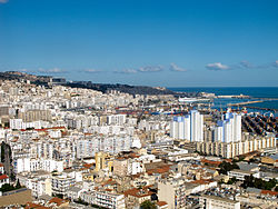
New Aɣmat City
Azaɣar Aɣmat n Assa | |
|---|---|
Capital | |
 | |
| Country | Messidor Union |
| Nation | Aɣmatia |
| Province | New Aɣmat |
| Neighbourhoods: | List
|
| Founded | c. 3800 BCE (Old Aɣmat) 1441 CE (New Aɣmat) |
| Government | |
| • Type | City council |
| • Body | New Aɣmat City Workers' Council |
| Area | |
| • Capital | 823 km2 (318 sq mi) |
| • Metro | 16,618 km2 (6,416 sq mi) |
| Highest elevation | 375 m (1,230 ft) |
| Lowest elevation | 0 m (0 ft) |
| Population (2018) | |
| • Capital | 8,873,785 |
| • Density | 11,000/km2 (28,000/sq mi) |
| Demonym | New Aɣmatian |
| Dial code | 381 |
Header