Éinauna Grasslands: Difference between revisions
Jump to navigation
Jump to search
No edit summary |
No edit summary |
||
| Line 1: | Line 1: | ||
{{Infobox country geography | {{Infobox country geography | ||
| name = the Éinauna Grasslands | | name = the Éinauna Grasslands | ||
| image name = | | image name = File:Grasslands of Gotneska.jpg | ||
| image size = | | image size = | ||
| image caption = | | image caption = | ||
| Line 8: | Line 8: | ||
| map size = | | map size = | ||
| map_alt = | | map_alt = | ||
| continent = [[Argis]], [[Yeetland]] | | continent = [[Argis]], [[Yeetland Geography,Yeetland]] | ||
| region = | | region = Northern[[Gotneska]] | ||
| coordinates = <!-- Use {{Coord}} --> | | coordinates = <!-- Use {{Coord}} --> | ||
| area ranking = | | area ranking = | ||
Revision as of 01:10, 1 June 2022
 | |
 | |
| Continent | Argis, Yeetland Geography,Yeetland |
|---|---|
| Region | NorthernGotneska |
| Highest point | 5,298m |
| Lowest point | 1,453m |
| Climate | Subargic |
| Natural Hazards | Extreme Cold (Winter Time only), Extreme Winds, Flash Floods |
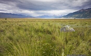
The Éinauna Grasslands (Götaish: Féaraigh Éinauna) is a broad expanse of flatland in Argis, mostly within Gotneska. It is mostly located west of tbd river and east of the Kendovstrunmahhe Mountains, much of it covered in prairie, steppe and grassland.