Dar Al Hamma Province: Difference between revisions
Jump to navigation
Jump to search
No edit summary |
|||
| Line 72: | Line 72: | ||
| national_representation_type2 = | | national_representation_type2 = | ||
| national_representation2 = | | national_representation2 = | ||
| area_km2 = | | area_km2 = 4,068.75 | ||
| area_rank = | | area_rank = | ||
| area_sq_mi = | | area_sq_mi = | ||
Revision as of 18:52, 11 December 2022
Dar Al Hamma Province محافظة دار الحامة | |
|---|---|
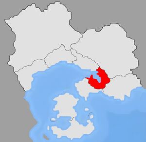
Location of Dar Al Hamma province in Salamat. | |
| Province | September 17 1969 |
| Named for | Dar Al Hamma |
| Capital and largest city | Dar Al Hamma |
| Official languages | Arabic |
| Ethnic groups | Arab |
| Religion | Islam |
| Demonym(s) | Hammadi |
| Area | |
• Total | 4,068.75 km2 (1,570.95 sq mi) |
| Elevation | 144 m (472 ft) |
| Population | |
• 2022 census | 5,233,162 |
| Currency | Salamati Dinar (SLD) |
| Time zone | UTC-1 (SLT) |
| Driving side | right |
| Calling code | +395-01 |
| ISO 3166 code | SL-01 |
| Internet TLD | .sl |
The Dar Al Hamma province is one of the 10 provinces of Salamat, located in eastern Salamat, it is home to the capital, Dar Al Hamma, and is one of the most populated regions of Salamat.
Subdivisions
Dairas (Districts)
- Dar Al Hamma
- Narqa
- Jadhab
- Douar Ghali
- El Ayyubi
- Bosco
- Bin Latif
- Tatareg
- Qasr Tahar
- El Haraqi
