Jundiboraí: Difference between revisions
Jump to navigation
Jump to search
mNo edit summary |
mNo edit summary |
||
| Line 21: | Line 21: | ||
|other_symbol_type = <!--Use if a further symbol exists, e.g. hymn--> | |other_symbol_type = <!--Use if a further symbol exists, e.g. hymn--> | ||
|other_symbol = | |other_symbol = | ||
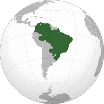
|image_map = <!--e.g. LocationCountry.svg--> | |image_map = <!--e.g. LocationCountry.svg--> File:Jundiboraí.png | ||
|loctext = <!--text description of location of country--> | |loctext = <!--text description of location of country--> | ||
|alt_map = <!--alt text for map--> | |alt_map = <!--alt text for map--> | ||
|map_caption = <!--Caption to place below map--> | |map_caption = <!--Caption to place below map--> | ||
Revision as of 18:39, 18 December 2022
People's Republic of Jundiboraí República Popular de Jundiboraí Jundiboraí Tekoha Tetã | |
|---|---|
 | |
| Capital | São Benaus 15° 47′ 38.0004″ S 47° 52′ 58.0008″ W |
| Largest city | Anacapá |
| Official languages | Portuguese, French, Spanish, Guarani |
| Demonym(s) | Jundiboraense |
| Government | Federal presidential constitutional republic |
| Legislature | People's National Congress |
| Population | |
• 2022 census | 224,596,469 |
| Gini | 0.275 low |
| HDI | high |
| Currency | Jundiboraí Peso Fuerte (JPF) |
| Time zone | UTC-4 |
• Summer (DST) | UTC-5 |
| Driving side | right |
| Calling code | +955 |
Jundiboraí officially the People's Republic of Jundiboraí is the largest country in South America, which borders the Guyanas and Suriname by the north, Bolivia and Uruguay by the south, Peru, Colombia and Venezuela by the west and northwest respectively. By the east, it borders the Atlantic Ocean. It's territory is covered by dense kilometres of jungle, the Amazon forest, and the most important rivers of the continent are part of the country. Its capital is São Benaus.