Parindingmatampu: Difference between revisions
m (→Climate) |
m (→Climate) |
||
| Line 145: | Line 145: | ||
| 27|27.5|27.9|27.9|26.3|26.3|26|27.5|28.9|28.7|28.2|27.8<!--lows--> | | 27|27.5|27.9|27.9|26.3|26.3|26|27.5|28.9|28.7|28.2|27.8<!--lows--> | ||
| 333.2|376.5|455.3|538.8|671.4|299.2|285.7|281.3|483.5|517.8|649.9|318.3<!--rain--> | | 333.2|376.5|455.3|538.8|671.4|299.2|285.7|281.3|483.5|517.8|649.9|318.3<!--rain--> | ||
}} | |||
{{Weather box/concise_C | |||
| location=Kampong Tahok | |||
| sctemp= | |||
| 35.8|35.9|36.2|36.9|36.6|36.3|36.2|36.0|37.5|37.3|37.0|36.5<!--highs--> | |||
| 23|23|23.3|24.1|24.8|25.4|25|25|23|22|22|22.3<!--lows--> | |||
| 271.2|290.4|598.5|611.9|673.7|321.8 |96.2 |93.4 |156.9 |287.9|440.6|292<!--rain--> | |||
}} | }} | ||
Revision as of 16:57, 27 December 2022
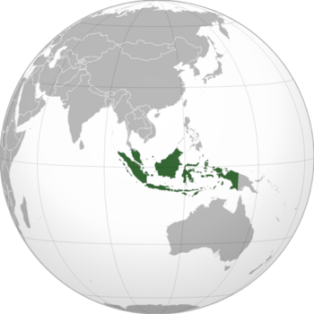
Parindingmatampu officially the Republic of Parindingmatampu is an island country in East Asia, known for its famous tropical islands and its kind population. Parindingeses love a good election, and the government gives them plenty of them. Universities tend to be full of students debating the merits of various civil and political rights, while businesses are tightly regulated and the wealthy viewed with suspicion. It meets to discuss matters of state in the capital city of Jambangan.
Geography
Climate
Located in the equator, Parindingmatampu climate is classified as tropical rainforest climate, with no significant variation between temperatures and abundant rainfall all year long without a significant dry season. September is the warmest month with a mean of 33.9 °C (93.0 °F) and the coolest is May with a mean of 31.2 °C (88.2 °F).
Rainfall is evenly distributed all year long, without a significant dry season. March-May and September-November are the two important rainy seasons, with the summer monsoon and the winter monsoon respectively. The driest month is August.
| Climate data for Jambangan | |||||||||||||
|---|---|---|---|---|---|---|---|---|---|---|---|---|---|
| Month | Jan | Feb | Mar | Apr | May | Jun | Jul | Aug | Sep | Oct | Nov | Dec | Year |
| Average high °C (°F) | 34.3 (93.7) |
34.6 (94.3) |
35.2 (95.4) |
35.9 (96.6) |
36.1 (97.0) |
36.6 (97.9) |
36.8 (98.2) |
36.5 (97.7) |
38.9 (102.0) |
37.8 (100.0) |
35.7 (96.3) |
35.2 (95.4) |
36.1 (97.0) |
| Average low °C (°F) | 27 (81) |
27.5 (81.5) |
27.9 (82.2) |
27.9 (82.2) |
26.3 (79.3) |
26.3 (79.3) |
26 (79) |
27.5 (81.5) |
28.9 (84.0) |
28.7 (83.7) |
28.2 (82.8) |
27.8 (82.0) |
27.5 (81.5) |
| Average precipitation mm (inches) | 333.2 (13.12) |
376.5 (14.82) |
455.3 (17.93) |
538.8 (21.21) |
671.4 (26.43) |
299.2 (11.78) |
285.7 (11.25) |
281.3 (11.07) |
483.5 (19.04) |
517.8 (20.39) |
649.9 (25.59) |
318.3 (12.53) |
5,210.9 (205.16) |
| Climate data for Kampong Tahok | |||||||||||||
|---|---|---|---|---|---|---|---|---|---|---|---|---|---|
| Month | Jan | Feb | Mar | Apr | May | Jun | Jul | Aug | Sep | Oct | Nov | Dec | Year |
| Average high °C (°F) | 35.8 (96.4) |
35.9 (96.6) |
36.2 (97.2) |
36.9 (98.4) |
36.6 (97.9) |
36.3 (97.3) |
36.2 (97.2) |
36.0 (96.8) |
37.5 (99.5) |
37.3 (99.1) |
37.0 (98.6) |
36.5 (97.7) |
36.5 (97.7) |
| Average low °C (°F) | 23 (73) |
23 (73) |
23.3 (73.9) |
24.1 (75.4) |
24.8 (76.6) |
25.4 (77.7) |
25 (77) |
25 (77) |
23 (73) |
22 (72) |
22 (72) |
22.3 (72.1) |
23.6 (74.4) |
| Average precipitation mm (inches) | 271.2 (10.68) |
290.4 (11.43) |
598.5 (23.56) |
611.9 (24.09) |
673.7 (26.52) |
321.8 (12.67) |
96.2 (3.79) |
93.4 (3.68) |
156.9 (6.18) |
287.9 (11.33) |
440.6 (17.35) |
292 (11.5) |
4,134.5 (162.78) |
