Tero Malstreciga: Difference between revisions
(Intro paragraphs) |
mNo edit summary |
||
| Line 118: | Line 118: | ||
Tero Malstreciga was inhabited by the [[Nunakuna]] and [[Nuintiqilla]] native peoples before settlers from [[Lov'Aniwa]], northern Mu-Kal, and [[Lira]] began establishing coastal towns throughout the early 1700s, leading to the establishment of the [[Ithsmia Colony]] under the [[Red Charter]] in 1766. Following the 1794-1798 [[Gallant War]], a constitutional convention held in Belaĝo led to the formation of the Republic of Tero Malstreciga. | Tero Malstreciga was inhabited by the [[Nunakuna]] and [[Nuintiqilla]] native peoples before settlers from [[Lov'Aniwa]], northern Mu-Kal, and [[Lira]] began establishing coastal towns throughout the early 1700s, leading to the establishment of the [[Ithsmia Colony]] under the [[Red Charter]] in 1766. Following the 1794-1798 [[Gallant War]], a constitutional convention held in Belaĝo led to the formation of the Republic of Tero Malstreciga. | ||
{{TOC limit|3}} | |||
== Etymology == | |||
== History == | |||
[[Category:Countries]] | [[Category:Countries]] | ||
Revision as of 02:25, 27 April 2019
This article is incomplete because it is pending further input from participants, or it is a work-in-progress by one author. Please comment on this article's talk page to share your input, comments and questions. Note: To contribute to this article, you may need to seek help from the author(s) of this page. |
Republic of Tero Malstreciga Respubliko Tero Malstreciga | |
|---|---|
|
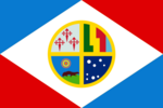
Flag | |
| Motto: "Pluen!" "Onwards!" | |
| Anthem: Dancanta Ĉevalo | |
| Capital | Urbo de Liberico |
| Largest city | Belaĝo |
| Official languages | Regulingvo |
| Recognised regional languages | Trankvilavano, Nunakuna |
| Demonym(s) | Malstrecigano |
| Government | Unitary Presidential Constitutional Republic |
| Antono Brava | |
• Supre de Ŝtata Konsilio | Ovidio Maciel |
• Seĝo de la Delegitoj | Mihaelo Vespera |
| Legislature | Nacia Asembleo |
| Ĉambro de Konsilistoj | |
| Ĉambro de Delegitoj | |
| Establishment | |
• Red Charter Signed | April 2nd, 1766 |
• Independence Declared | September 19th, 1794 |
• Belaĝo Constitutional Convention | December 6th, 1798 |
| Area | |
• | 179,789.8 km2 (69,417.2 sq mi) |
| Population | |
• 2019 estimate | 13,542,000 |
• Density | 75.3/km2 (195.0/sq mi) |
| GDP (nominal) | 2019 estimate |
• Total | $697.11 Billion |
• Per capita | $51,477.63 |
| Gini (2019) | 50.1 high |
| HDI (2019) | 0.859 very high |
| Currency | Stelo (STL) |
| Date format | yyyy-mm-dd (AB) |
| Driving side | right |
| Internet TLD | .tm |
Tero Malstreciga, officially the Republic of Tero Malstreciga (Regulingvo: Respubliko Tero Malstreciga), is a nation occupying the isthmus between the continents of Mu-Kal and Kanchaka, bordered to the south by Golidamanzi, to the north by ____, to the west by the Zerif Sea, and to the east by the Tobal Sea. It has a population of 13,542,000 in a land area of 179,789.8 km2. The capital city, Urbo de Liberico, is home to 657,000 people.
Tero Malstreciga is a Unitary Presidential Constitutional Republic. It is known for high standards of living and a strong democratic tradition, as well as increasing income inequality and accusations of corruption. The Republic is most well known for the Nikelo Canal, which connects the Zerif and Tobal Seas and puts billions of Steloj into the Malstrecigano economy every year.
Tero Malstreciga was inhabited by the Nunakuna and Nuintiqilla native peoples before settlers from Lov'Aniwa, northern Mu-Kal, and Lira began establishing coastal towns throughout the early 1700s, leading to the establishment of the Ithsmia Colony under the Red Charter in 1766. Following the 1794-1798 Gallant War, a constitutional convention held in Belaĝo led to the formation of the Republic of Tero Malstreciga.
