Akwaaba: Difference between revisions
mNo edit summary |
m (→Geography) |
||
| (2 intermediate revisions by the same user not shown) | |||
| Line 11: | Line 11: | ||
|alt_flag2 = <!--alt text for second flag--> | |alt_flag2 = <!--alt text for second flag--> | ||
|flag2_border = <!--set to no to disable border around the flag--> | |flag2_border = <!--set to no to disable border around the flag--> | ||
|image_coat = <!--e.g. Coat of arms of country.svg--> | |image_coat = <!--e.g. Coat of arms of country.svg--> File:Coat of arms of Benin.svg | ||
|alt_coat = <!--alt text for coat of arms--> | |alt_coat = <!--alt text for coat of arms--> | ||
|symbol_type = <!--emblem, seal, etc (if not a coat of arms)--> | |symbol_type = <!--emblem, seal, etc (if not a coat of arms)--> Emblem | ||
|symbol_footnote = <!--optional reference or footnote for the symbol caption--> | |symbol_footnote = <!--optional reference or footnote for the symbol caption--> | ||
|national_motto = <!--in inverted commas and wikilinked if link exists--> | |national_motto = <!--in inverted commas and wikilinked if link exists--> | ||
| Line 128: | Line 128: | ||
|footnotes = <!--For any generic non-numbered footnotes--> | |footnotes = <!--For any generic non-numbered footnotes--> | ||
}} | }} | ||
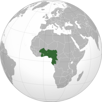
'''Akwaaba''' formally and officially the '''Federated States of Akwaaba''' is a country located in between West and Central West Africa, conforming one of the most populated countries and one of the largest countries by area in the globe. Akwaaba is formed by eight semi-independent countries, 142 states and subdivided in municipalities. It's capital is Abayomi, one of the most important ports in Africa and worldwide. | |||
Prior to the establishment of the federation, several ethnicities inhabited West Africa, but a sense of rivalry reigned between them all. Many of those tribes collaborated with the colonial authorities in order to harm their rivals. | |||
==Geography== | |||
Akwaba is situated between the Sahelian and the tropical regions. However, most of the country is situated in the tropical region. The temperatures are very high all year round, with a mean around {{convert|30|C|F}}. There are two seasons, a scorching hot and dry that goes from April through mid-September and a rainy one the remaining of the year. | |||
{{Weather box | {{Weather box | ||
| Line 176: | Line 184: | ||
|Feb precipitation mm = 187.5 | |Feb precipitation mm = 187.5 | ||
|Mar precipitation mm = 186.6 | |Mar precipitation mm = 186.6 | ||
|Apr precipitation mm = | |Apr precipitation mm = 89.9 | ||
|May precipitation mm = | |May precipitation mm = 80.4 | ||
|Jun precipitation mm = | |Jun precipitation mm = 73.2 | ||
|Jul precipitation mm = | |Jul precipitation mm = 71.7 | ||
|Aug precipitation mm = | |Aug precipitation mm = 69.9 | ||
|Sep precipitation mm = 95.3 | |Sep precipitation mm = 95.3 | ||
|Oct precipitation mm = 189.4 | |Oct precipitation mm = 189.4 | ||
Latest revision as of 19:39, 31 May 2023
Federated States of Akwaaba | |
|---|---|
 | |
| Capital | Abayomi |
| Government | Federal multi-ethnic semi-presidential constitutional republic |
| Population | |
• 2022 estimate | 340,469,617 |
Akwaaba formally and officially the Federated States of Akwaaba is a country located in between West and Central West Africa, conforming one of the most populated countries and one of the largest countries by area in the globe. Akwaaba is formed by eight semi-independent countries, 142 states and subdivided in municipalities. It's capital is Abayomi, one of the most important ports in Africa and worldwide.
Prior to the establishment of the federation, several ethnicities inhabited West Africa, but a sense of rivalry reigned between them all. Many of those tribes collaborated with the colonial authorities in order to harm their rivals.
Geography
Akwaba is situated between the Sahelian and the tropical regions. However, most of the country is situated in the tropical region. The temperatures are very high all year round, with a mean around 30 °C (86 °F). There are two seasons, a scorching hot and dry that goes from April through mid-September and a rainy one the remaining of the year.
| Climate data for Abayomi | |||||||||||||
|---|---|---|---|---|---|---|---|---|---|---|---|---|---|
| Month | Jan | Feb | Mar | Apr | May | Jun | Jul | Aug | Sep | Oct | Nov | Dec | Year |
| Average high °C (°F) | 29.1 (84.4) |
32.1 (89.8) |
33.2 (91.8) |
33.7 (92.7) |
35.9 (96.6) |
41.8 (107.2) |
43.3 (109.9) |
43.6 (110.5) |
33.5 (92.3) |
32.2 (90.0) |
32.4 (90.3) |
31.0 (87.8) |
35.2 (95.3) |
| Daily mean °C (°F) | 24.5 (76.1) |
26.7 (80.1) |
28.3 (82.9) |
30.4 (86.7) |
32.1 (89.8) |
35.2 (95.4) |
36.4 (97.5) |
36.7 (98.1) |
29.7 (85.5) |
27.3 (81.1) |
27.1 (80.8) |
25.7 (78.3) |
30.0 (86.0) |
| Average low °C (°F) | 20.0 (68.0) |
21.3 (70.3) |
23.4 (74.1) |
27.2 (81.0) |
28.4 (83.1) |
28.7 (83.7) |
29.6 (85.3) |
29.9 (85.8) |
25.7 (78.3) |
22.5 (72.5) |
21.8 (71.2) |
20.5 (68.9) |
24.9 (76.9) |
| Average precipitation mm (inches) | 199.9 (7.87) |
187.5 (7.38) |
186.6 (7.35) |
89.9 (3.54) |
80.4 (3.17) |
73.2 (2.88) |
71.7 (2.82) |
69.9 (2.75) |
95.3 (3.75) |
189.4 (7.46) |
191.2 (7.53) |
198.7 (7.82) |
1,633.7 (64.32) |
| Source: [NAME OF THE WEBSITE] | |||||||||||||
