Kanbon: Difference between revisions
No edit summary |
No edit summary |
||
| Line 1: | Line 1: | ||
{{Infobox country | {{Infobox country | ||
|conventional_long_name = The Kingdom of Kanbon | |conventional_long_name = The Kingdom of Kanbon | ||
|native_name = ''Kân Bơ̄n Mōq Dé'' | |native_name = ''Kân Bơ̄n Mōq Dé'' ([[Kanbonese]]) | ||
|common_name = Kanbon | |common_name = Kanbon | ||
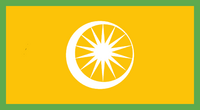
|image_flag = [[File:Flag of Kanbon.png|200px]] | |image_flag = [[File:Flag of Kanbon.png|200px]] | ||
|alt_flag = The national flag of the Kingdom of Kanbon | |alt_flag = The national flag of the Kingdom of Kanbon | ||
|image_coat = [[File:National Seal of Kanbon.png| | |image_coat = [[File:National Seal of Kanbon.png|150px]] | ||
|alt_coat = The national seal of the Kingdom of Kanbon | |alt_coat = The national seal of the Kingdom of Kanbon | ||
|national_motto = <!--in inverted commas and wikilinked if link exists--> | |national_motto = <!--in inverted commas and wikilinked if link exists--> | ||
|national_anthem = ''Ang Đuơn Bơng'' | |national_anthem = ''[[Ang Đuơn Bơng]]''<br> "Rows of Flowers" | ||
|image_map = [[File:Kanbon | |image_map = [[File:Map of Kanbon 2414.png|200px]] | ||
|alt_map = Location of Kanbon in the continent of Maipela | |alt_map = Location of Kanbon in the continent of Maipela | ||
|map_caption = Map of Kanbon | |map_caption = Map of Kanbon | ||
| Line 19: | Line 19: | ||
|official_languages = Kanbonese | |official_languages = Kanbonese | ||
|national_languages = <!--Country/territory-wide languages recognised but not necessarily in country/territory-wide law, etc--> | |national_languages = <!--Country/territory-wide languages recognised but not necessarily in country/territory-wide law, etc--> | ||
|regional_languages = Preung, Vơch, Anjamese, Market Rosian, Mensprechen, Koraelian, Sahsuo | |regional_languages = Preung, Vơch, Anjamese, Market Rosian, Mensprechen, Koraelian, Mon, Lomnan, Khomkan, Sahsuo, Nanyang | ||
|ethnic_groups = Kanbonic, Khomanian, Rosian | |ethnic_groups = Kanbonic, Khomanian, Rosian | ||
|ethnic_groups_year = 2403 | |ethnic_groups_year = 2403 | ||
|demonym = Kanbon, | |demonym = Kanbon, Kanbonian | ||
|government_type = Parliamentary Monarchy | |government_type = Parliamentary Monarchy | ||
|leader_title1 = King | |leader_title1 = King | ||
|leader_name1 = Kronâm VI | |leader_name1 = Kronâm VI | ||
|leader_title2 = Prime Minister | |leader_title2 = Prime Minister | ||
|leader_name2 = | |leader_name2 = Wî Dáng Ong | ||
|legislature = The Central Government | |legislature = The Central Government | ||
|upper_house = <!--Name of governing body's upper house, if given (e.g. "Senate")--> | |upper_house = <!--Name of governing body's upper house, if given (e.g. "Senate")--> | ||
| Line 55: | Line 55: | ||
|date_format = YYYY/MM/DD<!--numeric dates (dd-mm-yyyy, yyyy.mm.dd, etc) plus era (CE, AD, AH, etc)--> | |date_format = YYYY/MM/DD<!--numeric dates (dd-mm-yyyy, yyyy.mm.dd, etc) plus era (CE, AD, AH, etc)--> | ||
|drives_on = right side <!--"right" or "left" (side of road)--> | |drives_on = right side <!--"right" or "left" (side of road)--> | ||
|cctld = <!--Internet country code top-level domain identifier (e.g. [[.br]], [[.de]], etc) | |cctld = <!--Internet country code top-level domain identifier (e.g. [[.br]], [[.de]], etc)--> | ||
|calling_code = <!--e.g. [[+1]], [[+531]], [[+44]], etc--> | |calling_code = <!--e.g. [[+1]], [[+531]], [[+44]], etc--> | ||
}} | }} | ||
Revision as of 16:55, 5 June 2023
The Kingdom of Kanbon Kân Bơ̄n Mōq Dé (Kanbonese) | |
|---|---|
| Anthem: Ang Đuơn Bơng "Rows of Flowers" | |
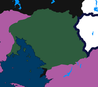
 Map of Kanbon | |
| Capital and largest city | Zên Trúơ |
| Official languages | Kanbonese |
| Recognised regional languages | Preung, Vơch, Anjamese, Market Rosian, Mensprechen, Koraelian, Mon, Lomnan, Khomkan, Sahsuo, Nanyang |
| Ethnic groups (2403) | Kanbonic, Khomanian, Rosian |
| Demonym(s) | Kanbon, Kanbonian |
| Government | Parliamentary Monarchy |
• King | Kronâm VI |
• Prime Minister | Wî Dáng Ong |
| Legislature | The Central Government |
| Establishment | |
• Founding of the Kanbon Kingdom | 375 PL |
• Fall of the First Kanbon Kingdom | 1050 PL |
• Conquered Under the Irmiyad Empire | 1149 - 1677 PL |
• Split of the Irmiyad Empire and the Reestablishment of the Kanbon Kingdom | 1677 PL |
| Population | |
• 2408 census | 59.3 million |
• Density | 44/km2 (114.0/sq mi) |
| HDI | 0.746 high |
| Currency | Bak (B̆) |
| Date format | YYYY/MM/DD |
| Driving side | right side |
Kanbon ,(/ˈkænbɔn/; Kanbonese: Kân Bơ̄n, pronounced [kan˦ ɓən˩]), officially the Kingdom of Kanbon, is a country in Maipela, spanning an area of 1,332,049 square kilometres (514,306 sq mi), bordered by Saxet-Monteri on both to the east and west, and the Kanbonic Gulf to the south. The capital and largest city is Zên Trúơ. The official language is Kanbonese, the most spoken language in the Kanbonic language family.
Kanbon has been inhabited since roughbly 400 BPL. The first ever Kanbonic Kingdom was established by Cāk Srey Nô in 375 PL, who declared himself king uniting the warring Kanbonic princes under the name "Kanbon" after a river next to his residence. The kingdom flourished for over 600 years, who single handedly spread Chitroism across the trade route, building several large scale monuments, and leaving pages upon pages of scriptures in the Kanbonic script, from poems to entire folklores. Soon the kingdom fell in 1050 and the remains of the kingdom went into a warring states period before swiftly conquered by the Irmiyad Empire, The Irmiyads ruled the land and carried out the Kanbonic genocide in the 1400's. In 1620, the Kanbonese, Khomans, and Preungs unite under the Kanbon tricolour banner, and declared the refoundation of the Second Kingdom of Kanbon in 1677.

