Chutorozen: Difference between revisions
Jump to navigation
Jump to search
mNo edit summary |
mNo edit summary |
||
| (4 intermediate revisions by the same user not shown) | |||
| Line 1: | Line 1: | ||
{{Infobox country | {{Infobox country | ||
|micronation = <!--yes if a micronation--> | |micronation = <!--yes if a micronation--> | ||
|conventional_long_name = <!--Formal or official full name of the country in English--> | |conventional_long_name = <!--Formal or official full name of the country in English--> State of Chutorozen | ||
|native_name = <!--Country's name (usually full name) in its native language, hence in italics (double quotemarks)--> | |native_name = <!--Country's name (usually full name) in its native language, hence in italics (double quotemarks)--> {{native name|ja|ちゅとろぜん国}}<br>''Chutorozen-koku'' | ||
|common_name = <!--Common name in English (used for wikilinks, captions, and to produce a default iso3166 code)--> | |common_name = <!--Common name in English (used for wikilinks, captions, and to produce a default iso3166 code)--> | ||
|status = <!--Status of country, especially useful for micronations--> | |status = <!--Status of country, especially useful for micronations--> | ||
| Line 130: | Line 130: | ||
}} | }} | ||
Chutorozen officially the State of Chutorozen is an island country in East Asia. It's capital and largest city is Dorayaki-kyō. | '''Chutorozen''' officially the '''State of Chutorozen''' is an island country in East Asia. It comprises of 32 prefectures and subdivided in 5 regions. It's capital and largest city is Dorayaki-kyō. | ||
==Geography== | ==Geography== | ||
===Climate=== | ===Climate=== | ||
Most if not all the country is under the oceanic climate (''Cfb'') with cool wet summers and cool dry winters. Variability between the average temperatures in the coldest month and the warmest is scarce. | |||
{{Weather box | {{Weather box | ||
Latest revision as of 15:26, 22 June 2023
State of Chutorozen | |
|---|---|
| Anthem: "抜刀隊" Battōtai (English: "Drawn-Sword Regiment") | |
 | |
| Capital | Dorayaki-kyō |
| Official languages | Japanese |
| Religion | Shintō |
| Demonym(s) | Chutorozenese |
| Government | Unitary one-party socialist republic under an autocrazy |
• Supreme Leader | Nobita Nobi |
• Chairman of Chutorozen Socialist Workers' Party | Nobisuke Nobi Jr. |
| Currency | Onigiri (お/CTO) |
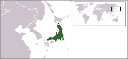
Chutorozen officially the State of Chutorozen is an island country in East Asia. It comprises of 32 prefectures and subdivided in 5 regions. It's capital and largest city is Dorayaki-kyō.
Geography
Climate
Most if not all the country is under the oceanic climate (Cfb) with cool wet summers and cool dry winters. Variability between the average temperatures in the coldest month and the warmest is scarce.
| Climate data for Dorayaki-kyō | |||||||||||||
|---|---|---|---|---|---|---|---|---|---|---|---|---|---|
| Month | Jan | Feb | Mar | Apr | May | Jun | Jul | Aug | Sep | Oct | Nov | Dec | Year |
| Average high °C (°F) | 15.1 (59.2) |
17.2 (63.0) |
17.3 (63.1) |
18.4 (65.1) |
20.5 (68.9) |
22.6 (72.7) |
24.7 (76.5) |
22.8 (73.0) |
21.9 (71.4) |
19.0 (66.2) |
18.1 (64.6) |
15.2 (59.4) |
19.4 (66.9) |
| Daily mean °C (°F) | 12.5 (54.5) |
14.1 (57.4) |
14.2 (57.6) |
15.3 (59.5) |
17.4 (63.3) |
18.5 (65.3) |
19.6 (67.3) |
18.2 (64.8) |
17.3 (63.1) |
15.7 (60.3) |
15.0 (59.0) |
13.1 (55.6) |
15.9 (60.6) |
| Average low °C (°F) | 10.0 (50.0) |
11.1 (52.0) |
11.2 (52.2) |
12.3 (54.1) |
14.4 (57.9) |
14.5 (58.1) |
14.6 (58.3) |
13.7 (56.7) |
12.8 (55.0) |
12.5 (54.5) |
12.0 (53.6) |
11.1 (52.0) |
12.5 (54.5) |
| Average precipitation mm (inches) | 11.1 (0.44) |
32.2 (1.27) |
60.3 (2.37) |
65.4 (2.57) |
78.5 (3.09) |
94.6 (3.72) |
99.7 (3.93) |
94.8 (3.73) |
57.9 (2.28) |
37.0 (1.46) |
32.1 (1.26) |
22.2 (0.87) |
685.8 (26.99) |
| Source: [NAME OF THE WEBSITE] | |||||||||||||