North Tobanam: Difference between revisions
Jump to navigation
Jump to search
(Created page with "{{Infobox country |micronation = <!--yes if a micronation--> |conventional_long_name = <!--Formal or official full name of the country in English--> |native_name =...") |
mNo edit summary |
||
| Line 21: | Line 21: | ||
|other_symbol_type = <!--Use if a further symbol exists, e.g. hymn--> | |other_symbol_type = <!--Use if a further symbol exists, e.g. hymn--> | ||
|other_symbol = | |other_symbol = | ||
|image_map = <!--e.g. LocationCountry.svg--> | |image_map = <!--e.g. LocationCountry.svg--> File:North Tobanam map.png | ||
|loctext = <!--text description of location of country--> | |loctext = <!--text description of location of country--> | ||
|alt_map = <!--alt text for map--> | |alt_map = <!--alt text for map--> | ||
| Line 48: | Line 48: | ||
|religion_year = <!--Year of religion data (if provided)--> | |religion_year = <!--Year of religion data (if provided)--> | ||
|religion_ref = <!--(for any ref/s to associate with religion data)--> | |religion_ref = <!--(for any ref/s to associate with religion data)--> | ||
|demonym = <!--Term/s describing those associated with the country/territory (e.g. "Belgian" for the country Belgium)--> | |demonym = <!--Term/s describing those associated with the country/territory (e.g. "Belgian" for the country Belgium)--> Tobanamean<br>Tobanamois, -e (French) | ||
|government_type = <!--(often a compound multi-wikilinked term, e.g. "Federal semi-presidential constitutional republic", etc)--> | |government_type = <!--(often a compound multi-wikilinked term, e.g. "Federal semi-presidential constitutional republic", etc)--> Unitary semi-presidential constitutional republic | ||
|leader_title1 = <!--(for a country, usually the head of state's (wikilinked) title, e.g. "President", "Monarch")--> | |leader_title1 = <!--(for a country, usually the head of state's (wikilinked) title, e.g. "President", "Monarch")--> | ||
|leader_name1 = | |leader_name1 = | ||
| Line 71: | Line 71: | ||
|area_rank = | |area_rank = | ||
|area = <!--Major area size (in [[Template:convert]] either km2 or sqmi first)--> | |area = <!--Major area size (in [[Template:convert]] either km2 or sqmi first)--> | ||
|area_km2 = <!--Major area size (in square km)--> | |area_km2 = <!--Major area size (in square km)--> 649,950 | ||
|area_sq_mi = <!--Area in square mi (requires area_km2)--> | |area_sq_mi = <!--Area in square mi (requires area_km2)--> | ||
|area_footnote = <!--Optional footnote for area--> | |area_footnote = <!--Optional footnote for area--> | ||
|percent_water = | |percent_water = | ||
|area_label = <!--Label under "Area" (default is "Total")--> | |area_label = <!--Label under "Area" (default is "Total")--> Total | ||
|area_label2 = <!--Label below area_label (optional)--> | |area_label2 = <!--Label below area_label (optional)--> | ||
|area_data2 = <!--Text after area_label2 (optional)--> | |area_data2 = <!--Text after area_label2 (optional)--> | ||
|population_estimate = | |population_estimate = 89,637 | ||
|population_estimate_rank = | |population_estimate_rank = | ||
|population_estimate_year = | |population_estimate_year = 2016 | ||
|population_census = | |population_census = | ||
|population_census_year = | |population_census_year = | ||
| Line 122: | Line 122: | ||
|image_map3 = <!--Optional third map position, e.g. for use with reference to footnotes below it--> | |image_map3 = <!--Optional third map position, e.g. for use with reference to footnotes below it--> | ||
|alt_map3 = <!--alt text for third map position--> | |alt_map3 = <!--alt text for third map position--> | ||
|footnote_a = <!--For any footnote <sup>a</sup> used above--> | |footnote_a = <!--For any footnote <sup>a</sup> used above--> Area includes the demilitarized zone (1994) | ||
|footnote_b = <!--For any footnote <sup>b</sup> used above--> | |footnote_b = <!--For any footnote <sup>b</sup> used above--> | ||
<!--......--> | <!--......--> | ||
Revision as of 18:28, 4 August 2023
République du Tobanam du Nord (French) | |
|---|---|
| Motto: Prenons le risque de penser ce que nous voulons pour notre avenir (French) Let's take the risk of thinking what we want for our future | |
 | |
| Capital and largest city | Marxesbourg |
| Official languages | French |
| Demonym(s) | Tobanamean Tobanamois, -e (French) |
| Government | Unitary semi-presidential constitutional republic |
| Area | |
• Total | 649,950 km2 (250,950 sq mi) |
| Population | |
• 2016 estimate | 89,637 |
| |
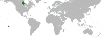
North Tobanam officially the Republic of North Tobanam is a country located in North America, currently being an enclave within Canada.
| Climate data for Marxesbourg | |||||||||||||
|---|---|---|---|---|---|---|---|---|---|---|---|---|---|
| Month | Jan | Feb | Mar | Apr | May | Jun | Jul | Aug | Sep | Oct | Nov | Dec | Year |
| Average high °C (°F) | 36.4 (97.5) |
39.3 (102.7) |
41.8 (107.2) |
42.8 (109.0) |
41.2 (106.2) |
38.2 (100.8) |
35.6 (96.1) |
34.6 (94.3) |
36.0 (96.8) |
39.1 (102.4) |
39.4 (102.9) |
36.9 (98.4) |
38.4 (101.2) |
| Daily mean °C (°F) | 28.2 (82.8) |
30.9 (87.6) |
34.4 (93.9) |
36.3 (97.3) |
35.4 (95.7) |
32.4 (90.3) |
30.4 (86.7) |
29.6 (85.3) |
30.9 (87.6) |
32.8 (91.0) |
30.7 (87.3) |
28.6 (83.5) |
31.7 (89.1) |
| Average low °C (°F) | 20.0 (68.0) |
22.5 (72.5) |
27.0 (80.6) |
29.9 (85.8) |
29.6 (85.3) |
26.6 (79.9) |
25.3 (77.5) |
24.7 (76.5) |
25.9 (78.6) |
26.5 (79.7) |
22.1 (71.8) |
20.4 (68.7) |
25.0 (77.1) |
| Average precipitation mm (inches) | 0.0 (0.0) |
11.3 (0.44) |
35.2 (1.39) |
69.5 (2.74) |
95.6 (3.76) |
596.1 (23.47) |
742.9 (29.25) |
969.4 (38.17) |
506.8 (19.95) |
392.7 (15.46) |
382.6 (15.06) |
60.3 (2.37) |
3,862.4 (152.06) |
| Source: [NAME OF THE WEBSITE] | |||||||||||||