Telento: Difference between revisions
Jump to navigation
Jump to search
(Created page with "{{Infobox country |micronation = <!--yes if a micronation--> |conventional_long_name = <!--Formal or official full name of the country in English--> |native_name =...") |
mNo edit summary |
||
| (One intermediate revision by the same user not shown) | |||
| Line 1: | Line 1: | ||
{{Infobox country | {{Infobox country | ||
|micronation = <!--yes if a micronation--> | |micronation = <!--yes if a micronation--> | ||
|conventional_long_name = <!--Formal or official full name of the country in English--> | |conventional_long_name = <!--Formal or official full name of the country in English--> People's Republic of Telento | ||
|native_name = <!--Republic of Pentium--> | |native_name = <!--Republic of Pentium--> {{native name|ita|Repubblica Popolare di Telento}} | ||
|common_name = <!--Pentium--> | |common_name = <!--Pentium--> | ||
|status = <!-- | |status = <!----> | ||
|image_flag = <!--e.g. Flag of country.svg--> File:Soviet padania.png | |||
--> | |||
|image_flag = <!--e.g. Flag of country.svg--> | |||
|alt_flag = <!--alt text for flag (text shown when pointer hovers over flag)--> | |alt_flag = <!--alt text for flag (text shown when pointer hovers over flag)--> | ||
|flag_border = <!--set to no to disable border around the flag--> | |flag_border = <!--set to no to disable border around the flag--> yes | ||
|image_flag2 = <!--e.g. Second-flag of country.svg--> | |image_flag2 = <!--e.g. Second-flag of country.svg--> | ||
|alt_flag2 = <!--alt text for second flag--> | |alt_flag2 = <!--alt text for second flag--> | ||
|flag2_border = <!--set to no to disable border around the flag--> | |flag2_border = <!--set to no to disable border around the flag--> | ||
|image_coat = <!--e.g. Coat of arms of country.svg--> | |image_coat = <!--e.g. Coat of arms of country.svg--> File:Coat of arms of telento.png | ||
|alt_coat = <!--alt text for coat of arms--> | |alt_coat = <!--alt text for coat of arms--> | ||
|symbol_type = <!--emblem, seal, etc (if not a coat of arms)--> | |symbol_type = <!--emblem, seal, etc (if not a coat of arms)--> | ||
| Line 26: | Line 21: | ||
|other_symbol_type = <!--Use if a further symbol exists, e.g. hymn--> | |other_symbol_type = <!--Use if a further symbol exists, e.g. hymn--> | ||
|other_symbol = | |other_symbol = | ||
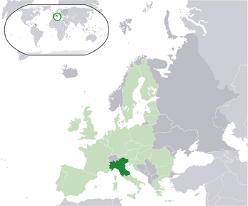
|image_map = <!--e.g. LocationCountry.svg--> | |image_map = <!--e.g. LocationCountry.svg--> File:Location_map_Padania.png | ||
|loctext = <!--text description of location of country--> | |loctext = <!--text description of location of country--> | ||
|alt_map = <!--alt text for map--> | |alt_map = <!--alt text for map--> | ||
| Line 33: | Line 28: | ||
|alt_map2 = <!--alt text for second map--> | |alt_map2 = <!--alt text for second map--> | ||
|map_caption2 = <!--Caption to place below second map--> | |map_caption2 = <!--Caption to place below second map--> | ||
|capital = <!--Name of country/territory's capital, wikilinked if link exists--> | |capital = <!--Name of country/territory's capital, wikilinked if link exists--> Pomeriggio | ||
|coordinates = <!-- Coordinates for capital, using {{tl|coord}} --> | |coordinates = <!-- Coordinates for capital, using {{tl|coord}} --> | ||
|largest_city = <!--Name of country/territory's largest city. Use "capital" (without quotation marks) if it's the capital.--> | |largest_city = <!--Name of country/territory's largest city. Use "capital" (without quotation marks) if it's the capital.--> capital | ||
|largest_settlement_type = <!--Type of settlement if largest settlement not a city--> | |largest_settlement_type = <!--Type of settlement if largest settlement not a city--> largest city | ||
|largest_settlement = <!--Name of largest settlement--> | |largest_settlement = <!--Name of largest settlement--> | ||
|official_languages = <!--Languages recognised in legislation, constitution, etc--> | |official_languages = <!--Languages recognised in legislation, constitution, etc--> [[wikipedia:Italian language|Italian]] | ||
|national_languages = <!--Country/territory-wide languages recognised but not necessarily in country/territory-wide law, etc--> | |national_languages = <!--Country/territory-wide languages recognised but not necessarily in country/territory-wide law, etc--> | ||
|regional_languages = <!--Languages recognised or associated with particular regions within the country/territory--> | |regional_languages = <!--Languages recognised or associated with particular regions within the country/territory--> | ||
|languages_type = <!--Use to specify a further type of language, if not official, national or regional--> | |languages_type = <!--Use to specify a further type of language, if not official, national or regional--> | ||
Latest revision as of 17:02, 7 September 2023
People's Republic of Telento Repubblica Popolare di Telento (Italian) | |
|---|---|
 | |
| Capital and largest city | Pomeriggio |
| Official languages | Italian |
| Climate data for insert location | |||||||||||||
|---|---|---|---|---|---|---|---|---|---|---|---|---|---|
| Month | Jan | Feb | Mar | Apr | May | Jun | Jul | Aug | Sep | Oct | Nov | Dec | Year |
| Average high °C (°F) | 36.1 (97.0) |
38.2 (100.8) |
39.0 (102.2) |
39.7 (103.5) |
40.9 (105.6) |
42.2 (108.0) |
42.7 (108.9) |
42.7 (108.9) |
42.3 (108.1) |
41.4 (106.5) |
39.7 (103.5) |
38.5 (101.3) |
40.3 (104.5) |
| Daily mean °C (°F) | 22.5 (72.5) |
27.2 (81.0) |
28.5 (83.3) |
29.8 (85.6) |
31.9 (89.4) |
33.9 (93.0) |
35.4 (95.7) |
35.2 (95.4) |
33.1 (91.6) |
31.0 (87.8) |
29.0 (84.2) |
23.9 (75.0) |
30.1 (86.2) |
| Average low °C (°F) | 9.0 (48.2) |
16.3 (61.3) |
18.1 (64.6) |
20.0 (68.0) |
22.9 (73.2) |
25.6 (78.1) |
28.1 (82.6) |
27.8 (82.0) |
23.9 (75.0) |
20.6 (69.1) |
18.3 (64.9) |
9.4 (48.9) |
20.0 (68.0) |
| Average precipitation mm (inches) | 3,662.4 (144.19) |
1,925.1 (75.79) |
299.8 (11.80) |
94.3 (3.71) |
51.6 (2.03) |
34.2 (1.35) |
11.7 (0.46) |
19.5 (0.77) |
135.0 (5.31) |
708.1 (27.88) |
1,467.3 (57.77) |
7,995.2 (314.77) |
16,404.2 (645.83) |
| Source: [NAME OF THE WEBSITE] | |||||||||||||

