Western Atlantic: Difference between revisions
Jump to navigation
Jump to search
(Created page with "{{Infobox settlement | name = Western Atlantic | official_name = | image_map = WesternAtlantic.jpg | mapsize = 250px |...") |
No edit summary |
||
| (2 intermediate revisions by the same user not shown) | |||
| Line 1: | Line 1: | ||
{{wip}} | |||
{{Infobox settlement | {{Infobox settlement | ||
| name = Western Atlantic | | name = Western Atlantic | ||
| Line 5: | Line 7: | ||
| mapsize = 250px | | mapsize = 250px | ||
| coordinates = | | coordinates = | ||
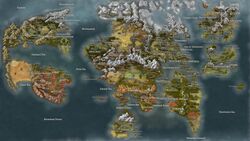
| map_caption = Map of the | | map_caption = Map of the Western Atlantic | ||
| subdivision_type = Region | | subdivision_type = Region | ||
| subdivision_name = | | subdivision_name = Western Atlantic | ||
| subdivision_type1 = | | subdivision_type1 = | ||
| subdivision_name1 = | | subdivision_name1 = | ||
| admin_center_type = | | admin_center_type = | ||
| other_name = | | other_name = | ||
| settlement_type = | | settlement_type = | ||
| area_magnitude = | | area_magnitude = | ||
| area_footnotes = | | area_footnotes = | ||
| area_total_km2 = | | area_total_km2 = | ||
| population_as_of = | | population_as_of = | ||
| population_footnotes = | | population_footnotes = | ||
| population_note = | | population_note = | ||
| population_total = | | population_total = | ||
| population_density_km2 = | | population_density_km2 = | ||
| population_demonym = | | population_demonym = | ||
| timezone = | | timezone = | ||
| utc_offset = | | utc_offset = | ||
| Line 40: | Line 29: | ||
| utc_offset_DST = | | utc_offset_DST = | ||
}} | }} | ||
The '''Western Atlantic''' is a region located in the western part of the [[Wikipedia:Atlantic Ocean|Atlantic Ocean]]. The region includes 34 nations, including, most prominently, the [[Caldan Union]], Pantocratoria, Excalbia, Knootoss, Snefaldia, Brasland, and Anahuac. The region consists of multiple continents, including [[Ambara]], [[Epheron]], and [[Vasconia]]. | |||
[[Category:Western Atlantic]] | [[Category:Western Atlantic]] | ||
Latest revision as of 22:47, 30 October 2023
This article is incomplete because it is pending further input from participants, or it is a work-in-progress by one author. Please comment on this article's talk page to share your input, comments and questions. Note: To contribute to this article, you may need to seek help from the author(s) of this page. |
Western Atlantic | |
|---|---|
 Map of the Western Atlantic | |
| Region | Western Atlantic |
The Western Atlantic is a region located in the western part of the Atlantic Ocean. The region includes 34 nations, including, most prominently, the Caldan Union, Pantocratoria, Excalbia, Knootoss, Snefaldia, Brasland, and Anahuac. The region consists of multiple continents, including Ambara, Epheron, and Vasconia.