Rousein: Difference between revisions
Jump to navigation
Jump to search
Mendozzau69 (talk | contribs) No edit summary |
Mendozzau69 (talk | contribs) No edit summary |
||
| Line 114: | Line 114: | ||
|antipodes = <!--Place/s exactly on the opposite side of the world to country/territory--> | |antipodes = <!--Place/s exactly on the opposite side of the world to country/territory--> | ||
|date_format = <!--all-numeric date format and era, such as [[Common Era|CE]], [[Anno Domini|AD]], [[Hijri year|AH]], etc.; e.g. {{abbr|yyyy|year}}-{{abbr|mm|month}}-{{abbr|dd|day}} ([[Anno Domini|AD]]) --> | |date_format = <!--all-numeric date format and era, such as [[Common Era|CE]], [[Anno Domini|AD]], [[Hijri year|AH]], etc.; e.g. {{abbr|yyyy|year}}-{{abbr|mm|month}}-{{abbr|dd|day}} ([[Anno Domini|AD]]) --> | ||
|drives_on = <!--"right" or "left" (side of road)--> | |drives_on = <!--"right" or "left" (side of road)--> right | ||
|cctld = <!--Internet country code top-level domain identifier (e.g. [[.br]], [[.de]], etc)--> | |cctld = <!--Internet country code top-level domain identifier (e.g. [[.br]], [[.de]], etc)--> | ||
|iso3166code = <!--ISO code only; no extra text. Use to override default from common_name parameter above; omit using "omit".--> | |iso3166code = <!--ISO code only; no extra text. Use to override default from common_name parameter above; omit using "omit".--> | ||
|calling_code = <!--e.g. [[+1]], [[+531]], [[+44]], etc--> | |calling_code = <!--e.g. [[+1]], [[+531]], [[+44]], etc--> | ||
|patron_saint = <!--Use patron_saints for multiple--> | |patron_saint = <!--Use patron_saints for multiple--> | ||
|image_map3 = <!--Optional third map position, e.g. for use with reference to footnotes below it--> | |image_map3 = <!--Optional third map position, e.g. for use with reference to footnotes below it--> Map of Rousein with Capital City and Herduchéttes.png | ||
|alt_map3 = <!--alt text for third map position--> | |alt_map3 = <!--alt text for third map position--> | ||
|footnote_a = <!--For any footnote <sup>a</sup> used above--> | |footnote_a = <!--For any footnote <sup>a</sup> used above--> | ||
Revision as of 19:05, 26 November 2023
Jarldom of Rousein Jarldømmé de Rousein | |
|---|---|
| Motto: Vur Rousein, vilje donnegi ma liv! For Rousein, I'll give my life! | |
| Anthem: Ma Patrielan Royal anthem: Lenve lentre vår Jarl | |
 Rousein on Saurth | |
 Rousein within Noraugalwyn | |
| Location | Noraugalwyn |
| Capital | Milieugar |
| Official languages | Rouseinisch, Callaise |
| Recognised national languages | Alennic, Rouseinisch Sign Language |
| Ethnic groups | Rouseiner 88%, Callais Rouseiner 6%, Alenner (Mountain Natives), Envyner, Galavarian, Taevetti, Lisennisan, other non-Rouseiner |
| Religion | Reformed Valhennic 80%, Old Valhennic 5%, Callais Astraism, Alennic Valdennic, Envynic Forcatic, no religion 10%, other |
| Demonym(s) | Rouseiner |
| Government | Unitary Parliamentary Semi-constitutional Monarchy |
• Jarl | Lottwir II Bonnami-Lannevai |
• Hermon-Regent (Prime Minister) | Karles Lecorri |
• Grand Herduc-Regent (Minister of Noble Interests, Representative of Nobility) | Steffenos Julle Bardenos Granxendre |
| Legislature | Rouseiner Parliament |
| Occistag | |
| Valstag | |
• Density | 130/km2 (336.7/sq mi) |
| Currency | Rouseiner crown |
| Driving side | right |
| Location of Rousein | |
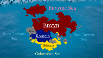
Rousein, formally the Jarldom of Rousein, is a semi-constitutional monarchy located in the North of Saurth on the continent of "Noraugalwyn" (local rouseiner expression) bordering Envyn, Galavaria and Taevetti Confederation. Capital city of Rousein is Milieugar. Rouseiners are highly religious and predominantly Reformed Valhennic with "controversial views" on gender identity and rights of women. Population density of Rousein is 130 People Per Square Kilometre.

