Slávu: Difference between revisions
Jump to navigation
Jump to search
Slovertia12 (talk | contribs) No edit summary |
mNo edit summary |
||
| (16 intermediate revisions by one other user not shown) | |||
| Line 1: | Line 1: | ||
{{Infobox mountain | {{Infobox mountain | ||
| name = Slávu | | name = Slávu | ||
| photo = | | other_name = | ||
| photo_caption = | | etymology = | ||
| elevation_m = | | native_name = | ||
| elevation_ref = | | native_name_lang = Sloverti | ||
| prominence_m = 168 | | translation = Glory | ||
| prominence_ref = | | pronunciation = | ||
| | | photo = Elferspitze.jpg | ||
| | | photo_size = 600px | ||
| | | photo_alt = | ||
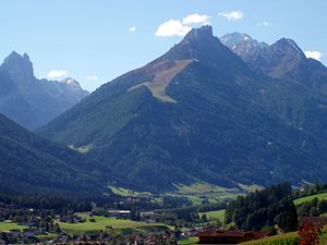
| | | photo_caption = Peak of Slávu | ||
| | | map = | ||
| | | map_image = | ||
| | | map_alt = | ||
| | | map_caption = | ||
| | | map_relief = | ||
| type = Granite | | map_size = | ||
| easiest_route = Hiking | | location = [[South Mazuria]], [[Slovertia]] | ||
| | | label = | ||
| label_position = | |||
| elevation = | |||
| elevation_m = 2,877 | |||
| elevation_ft = auto | |||
| elevation_ref = | |||
| prominence = | |||
| prominence_m = 168 | |||
| prominence_ft = | |||
| prominence_ref = | |||
| isolation = | |||
| isolation_km = | |||
| isolation_mi = | |||
| isolation_ref = | |||
| parent_peak = | |||
| listing = [[List of highest points of Astyrian countries|Country high point]] | |||
| range = | |||
| coordinates = | |||
| coordinates_ref = | |||
| topo = | |||
| type = | |||
| age = | |||
| geology = Granite | |||
| volcanic_arc = | |||
| volcanic_belt = | |||
| volcanic_field = | |||
| volcanic_arc/belt = | |||
| last_eruption = | |||
| first_ascent = 1844 By Edeond Varisny. | |||
| easiest_route = Hiking | |||
| normal_route = | |||
| access = | |||
| child = | |||
| embedded = | |||
}} | }} | ||
Slávu is a mountain in the Srebrogora mountains in northern [[Slovertia]], The mountain is popular amongst nature lovers and tourists. The mountain is accessible along maintained marked trails and with the exceptional vistas afforded from its summit it has become one of Slovertia's greatest attractions for nature tourism. Slávu has also been a major symbol in Sloverti and Mazurian ethnic and national identity and has been featured in many Soverti paintings and writings. It appears on the [[Sloverti Koruna|banknotes]] and stamps of [[Slovertia]]. | |||
[[Category: Slovertia]] [[Category: Astyria]] [[Category: Geography of Slovertia]][[Category:Country high points of Astyria]] | |||
Latest revision as of 21:50, 1 February 2024
| Slávu | |
|---|---|
 Peak of Slávu | |
| Highest point | |
| Elevation | 2,877 m (9,439 ft) |
| Prominence | 168 m (551 ft) |
| Listing | Country high point |
| Naming | |
| Translation | Glory |
| Geography | |
| Location | South Mazuria, Slovertia |
| Geology | |
| Type of rock | Granite |
| Climbing | |
| First ascent | 1844 By Edeond Varisny. |
| Easiest route | Hiking |
Slávu is a mountain in the Srebrogora mountains in northern Slovertia, The mountain is popular amongst nature lovers and tourists. The mountain is accessible along maintained marked trails and with the exceptional vistas afforded from its summit it has become one of Slovertia's greatest attractions for nature tourism. Slávu has also been a major symbol in Sloverti and Mazurian ethnic and national identity and has been featured in many Soverti paintings and writings. It appears on the banknotes and stamps of Slovertia.