Garallin Lake: Difference between revisions
(Created page with " {{Infobox body of water | name = {{subst:PAGENAMEBASE}} Garallin Lake | native_name = {{native name list}} Garallin Budor (Yoganian/Kjerso) Lac Garallin...") |
No edit summary |
||
| (24 intermediate revisions by the same user not shown) | |||
| Line 1: | Line 1: | ||
{{Infobox body of water | {{Infobox body of water | ||
| name = | | name = Garallin Lake | ||
| native_name = | | native_name = ''Garallin Budor'' | ||
| other_name = | | other_name = | ||
<!-- Images --> | <!-- Images --> | ||
| image = [[File:Lakegarallin.jpg| | | image = [[File:Lakegarallin.jpg|300px|frameless]] | ||
| alt = | | alt = | ||
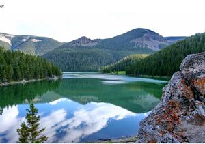
| caption = View of Lake Garallin | | caption = View of Lake Garallin | ||
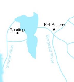
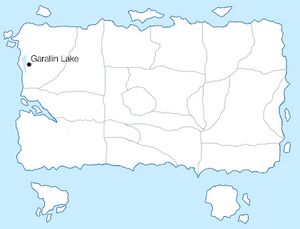
| image_bathymetry = | | image_bathymetry = {{switcher|[[File:Garallinlakemap.jpg|250px|frameless]]|Show map of rivers and settlements|[[File:Garallinlakemap2.jpg|300px|frameless]]|Show map of Yogania|default=1}} | ||
| alt_bathymetry = | | alt_bathymetry = | ||
| caption_bathymetry = | | caption_bathymetry = | ||
<!-- Stats --> | <!-- Stats --> | ||
| location = [[Yogania]] | | location = [[Yogania]] | ||
| group = | | group = | ||
| type = Freshwater Lake | |||
| type = Lake | |||
| etymology = | | etymology = | ||
| part_of = | | part_of = | ||
| inflow = | | inflow = | ||
| rivers = Burgaald River | | rivers = Burgaald River, Gunder River | ||
| outflow = | | outflow = | ||
| oceans = | | oceans = | ||
| catchment = <!-- {{convert|VALUE|UNITS}} must be used --> | | catchment = <!-- {{convert|VALUE|UNITS}} must be used --> | ||
| basin_countries = | | basin_countries = Yogania | ||
| agency = | | agency = | ||
| designation = | | designation = | ||
| Line 30: | Line 29: | ||
| engineer = | | engineer = | ||
| date-flooded = <!-- {{Start date|YYYY|MM|DD}} For man-made and other recent bodies of water --> | | date-flooded = <!-- {{Start date|YYYY|MM|DD}} For man-made and other recent bodies of water --> | ||
| length = <!-- {{convert|VALUE|UNITS}} must be used --> | | length = <!-- {{convert|VALUE|UNITS}} must be used --> {{convert|625|km2|sqmi}} | ||
| width = <!-- {{convert|VALUE|UNITS}} must be used --> | | width = <!-- {{convert|VALUE|UNITS}} must be used --> {{convert|101|km2|sqmi}} | ||
| area = <!-- {{convert|VALUE|UNITS}} must be used --> | | area = <!-- {{convert|VALUE|UNITS}} must be used -->{{convert|92000|km2|sqmi}} | ||
| depth = <!-- {{convert|VALUE|UNITS}} must be used --> | | depth = <!-- {{convert|VALUE|UNITS}} must be used --> {{convert|322|km2|sqmi}} | ||
| max-depth = <!-- {{convert|VALUE|UNITS}} must be used --> | | max-depth = <!-- {{convert|VALUE|UNITS}} must be used --> {{convert|721|km2|sqmi}} | ||
| volume = <!-- {{convert|VALUE|UNITS}} must be used --> | | volume = <!-- {{convert|VALUE|UNITS}} must be used -->{{convert|13000|km2|sqmi}} | ||
| residence_time = | | residence_time = | ||
| salinity = | | salinity = | ||
| shore = <!-- {{convert|VALUE|UNITS}} must be used --> | | shore = <!-- {{convert|VALUE|UNITS}} must be used -->{{convert|5223|km2|sqmi}} | ||
| elevation = <!-- {{convert|VALUE|UNITS}} must be used --> | | elevation = <!-- {{convert|VALUE|UNITS}} must be used --> | ||
| temperature_high = <!-- {{convert|VALUE|UNITS}} must be used --> | | temperature_high = <!-- {{convert|VALUE|UNITS}} must be used --> | ||
| Line 48: | Line 47: | ||
| trenches = | | trenches = | ||
| benches = | | benches = | ||
| cities = | | cities = Garaltug, Bol-Bugens | ||
<!-- Map --> | <!-- Map --> | ||
| pushpin_map = | | pushpin_map = | ||
| Line 59: | Line 58: | ||
}} | }} | ||
'''Garallin Lake''' (Yoganian/Kjerso: Garallin Budor), (French: Lac Garallin) is a freshwater lake located in the state of Popi, [[Yogania]]. It is the largest lake in the country, | '''Garallin Lake''' (Yoganian/Kjerso: Garallin Budor), (French: Lac Garallin) is a freshwater lake located in the state of Popi, [[Yogania]]. It is the largest lake in the country, with a surface area of 92000 square kilometers and depth of 322m. The Garallin Lake is part of the Protected Landmarks List of Yogania. The city of Garaltug is located directly next to the lake. | ||
==Etymology== | |||
The word Garallin comes from Old Yoganian word ''Garal'' meaning "water" or "liquid" and the word ''Bargaaldin'' meaning "frozen". An accurate translation of the word Garallin would be "frozen water. The lake was first mentioned with that name in a city archive document from 1292 A.D. The word ''Bargaaldiin'' was also the source for the name of the Burgaald River. | |||
==Overview== | |||
Lake Garallin empties into Lake Golst via the Burgaald River. It is the largest lake in Yogania by area, with 92000 km2. The main settlement located next to the lake is the city of Garaltug, with a population of 1,289,755 inhabitants. Another settlement located near the lake is the city of Bol-Bugens, built next to the Burgaald River with a population of 264,845 inhabitants. | |||
[[Category:Yogania]] | |||
Latest revision as of 13:22, 23 February 2024
| Garallin Lake Garallin Budor | |
|---|---|
 View of Lake Garallin | |
| Location | Yogania |
| Type | Freshwater Lake |
| River sources | Burgaald River, Gunder River |
| Basin countries | Yogania |
| Max. length | 625 square kilometres (241 sq mi) |
| Max. width | 101 square kilometres (39 sq mi) |
| Surface area | 92,000 square kilometres (36,000 sq mi) |
| Average depth | 322 square kilometres (124 sq mi) |
| Max. depth | 721 square kilometres (278 sq mi) |
| Water volume | 13,000 square kilometres (5,000 sq mi) |
| Shore length1 | 5,223 square kilometres (2,017 sq mi) |
| Settlements | Garaltug, Bol-Bugens |
| 1 Shore length is not a well-defined measure. | |
Garallin Lake (Yoganian/Kjerso: Garallin Budor), (French: Lac Garallin) is a freshwater lake located in the state of Popi, Yogania. It is the largest lake in the country, with a surface area of 92000 square kilometers and depth of 322m. The Garallin Lake is part of the Protected Landmarks List of Yogania. The city of Garaltug is located directly next to the lake.
Etymology
The word Garallin comes from Old Yoganian word Garal meaning "water" or "liquid" and the word Bargaaldin meaning "frozen". An accurate translation of the word Garallin would be "frozen water. The lake was first mentioned with that name in a city archive document from 1292 A.D. The word Bargaaldiin was also the source for the name of the Burgaald River.
Overview
Lake Garallin empties into Lake Golst via the Burgaald River. It is the largest lake in Yogania by area, with 92000 km2. The main settlement located next to the lake is the city of Garaltug, with a population of 1,289,755 inhabitants. Another settlement located near the lake is the city of Bol-Bugens, built next to the Burgaald River with a population of 264,845 inhabitants.

